
DC, geomob, and the Shoreditch Mapping party
Posted by Harry Wood on 30 May 2012 in English. Last updated on 1 June 2012.We had a bit of a lull in the OSMLondon events while I was away. I was away in Brasil as previously described here and away in Washington on a HOT board strategy meeting as mentioned on the HOT blog and in my #geomob talk. As well as HOT strategising, we were presenting at geoDC, panelling at the Wilson Centre, workshopping at the world bank, and taking the Humanitarian OpenStreetMap Team to the highest levels of government:

That was all a while ago now. #geomob was a geotastic follow up back here in London. Besides my HOT talk there were three other talks, this time not quite as OSMish, but still mucho mappy followed by pub. And then finally there was…
The first of the London Summer OpenStreetMap events. As it happened it coincided with what felt like the beginning of summer, so very pleasant to be hitting the streets to do a bit of mapping around Shoreditch. I was showing the ropes to somebody new. As usual while talking and mapping I didn’t do a very good job of it, and missed out all the best bits I actually needed to map. I shall have to pop back there on my lunch-break some time.
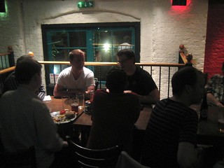
Then we gathered at the Strongroom Bar. I remembered going to this place on some previous occasion. It has a pleasant kind of alleyway place for drinking outdoors. It’s typically shoreditch hip and trendy and the high priced drinks paid the salaries of bar staff with particularly hip hair styles, who served drinks really slowly. So that was annoying, but as we find in loads of places, it got better when the afterwork crowd eased off, and we sat inside at a table.
Paul the archivist brought with him, not one, but two different print publications featuring many OpenStreetMap maps. The Crossrail information magazine is apparently available for free from the cross rail information centre and uses five or six map images of different crossrail sites across London. Then a book, the CAMRA Manchester Pub Guide with a loads of Manchester maps. Presumably not very far outside the city centre. Those areas are ranking poorly on mapping completeness (Need more Manchester mappers!)
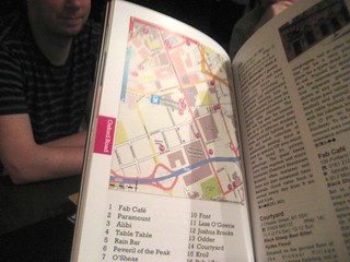
Paul also suggested a pub for the next London summer event. This’ll be cheaper. It’s a weatherspoons! The Crosse Keys is also situated nicely in a patch of missing building details in The City (map ) and also a lot of red patches which are soon to be redacted (Looks bad, but it’s mostly low value building outlines. Easily replaced).
So we’ll do another evening mapping party there next week on Thursday. All the details here. I’ve set the pub meeting time to 7:30 to give us a tad more mapping time. Let me know if you’d like to learn how mapping works and meet me at 6:30pm for a demo. For the rest you, the usual deal. Sign up for a slice of the cake. Do some mapping then head to the pub! Know anyone who lives outside London in a Liverpool Street station direction? Tell them about the event!
Additionally there’s an AGI event tomorrow night. A lecture at 6pm and then the geodrinks from 7:30. It’s kind of an “geo industry” thing, which might sound boring to some people, but these folks are always interested in chatting about OpenStreetMap, so I reckon I’ll go do that! See the kind of people who’ve signed up, and sign up yourself! (required)
Discussion