jmapb's Comments
| Changeset | When | Comment |
|---|---|---|
| 166679054 | Partially reverted in changeset/183746600 -- this changeset added invalid construction based on outdated imagery. In particular, way/1389210257 was added where Bing aerial shows construction beginning for a new bridge over the Esopus. The bridge was finished and mapped years ago, but it was incorrectly realigned in changeset/165022889 shortly before this changeset, which obviously led to some confusion here. When mapping without local knowledge, please pay attention to how the date of the aerial imagery compares to the date of recent edits. Bing is pretty old around here. Feel free to leave a map note or contact a local mapper in cases of ambiguity. Thanks, jmapb |
|
| 165022889 | Reverted in changeset/183746600 -- this changeset introduced incorrect road geometry based on outdated imagery. In particular, the bridge way/964074932 was moved to align with imagery of a previous, now-demolished bridge. When mapping without local knowledge, please pay attention to how the date of the aerial imagery compares to the date of recent edits. Bing aerial is pretty old around here. Feel free to leave a map note or contact a local mapper in cases of ambiguity. Thanks, jmapb |
|
| 182763423 | (see comments at changeset/138391273 and changeset/182755922) |
|
| 138391273 | (discussion continued at changeset/182755922) |
|
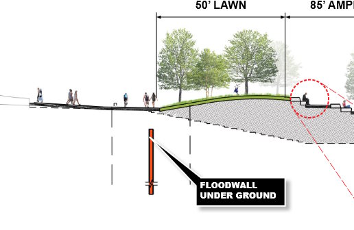
| 182755922 | (My changes were undone in way/1515002168, discussion here is continued from changeset/138391273) Compare man_made=dyke to this picture from page 32 of the linked pdf:
Maybe changing the tag would help, as well as tagging layer=-1 or location=underground. Regardless of the tagging choices, though, I think this approximate underground wall fails OSM's basic verifiability criteria, since a mapper on the ground can't confirm or improve it. (The inclusion of a check_date is especially odd -- nothing was checked!) I consider it to be part of the park's foundations, not a separate feature. |
|
| 138391273 | Finally, I'm really not sure these various flood control measures really merit a relation at all. IMO East Side Coastal Resiliency is a government initiative, not a geographic feature. But I left relation/16079502 alone, just deleted these two members. |
|
| 138391273 | Sometimes *is* helpful to map currently nonexistent features, if their geometry is actually known. In these cases it's best to use a lifecycle prefix (osm.wiki/Lifecycle_prefix) to ensure the map renderers and other data consumers won't see these features as current real data. Relying on tags like proposed= and start_date= isn't advisable, because you can't assume that data consumers will check for those. |
|
| 138391273 | Hi, I've removed the dykes way/1188974503 and way/1188974504 -- based on survey and imagery, these ways were running right through active parkland. Perhaps the plans changed, if so, this is a good example of why mapping things before they exist can be problematic. |
|
| 177786559 | That said, if the address is 570 5th Avenue, the architect really should have gone for 570 feet! Or 570.5 even! Total missed opportunity. |
|
| 177786559 | Don't stress out! ;) A fundamental principle of OSM is that what's on the map should match what's on the ground. Until there's an under-construction building that can be observed, mapping building=construction is premature. (building=construction says "the building should have at least the walls of the first floor" -- I think that's fair.) way/1471849035 is now rendering as a building, potentially confusing to anyone using this map for navigation and seeing just a hole in the ground. (The broken ground itself is already covered by the landuse=construction way/480796870.) So I've changed the footprint to proposed:building=yes and added a fixme tag to refine later. As far as the height goes -- 567 feet has three significant figures, so converting to 172.82 adds false precision. 173 would be more appropriate, 172.8 in a pinch because feet are smaller than meters. |
|
| 177786559 | Hi MadCat3D, regarding way/1471849035 -- construction hasn't begun on this building yet. What's your source for the building footprint, and building height accurate to the centimeter? |
|
| 181591272 | Changed this to building=construction -- fence is up but the building is still intact, and the only posted permit is for renovation of open space. I'll keep an eye on it of course. |
|
| 137571845 | Hi Chuckles 2, I've reverted this changeset with changeset/181514568. Bikeability is not a requirement for the highway=path tag. Furthermore, the bikeability of these particular paths is up to interpretation -- there are no restrictions signed or on the website. |
|
| 174440634 | Hi philpennmap, I've reverted this changeset with changeset/177724792 -- there was already an existing relation for Governors Island (relation/2389631). Please see comments on changeset/174440574 thanks, jmapb |
|
| 174440574 | Hi philpennmap, wireguy is correct here -- there was already a relation mapped for Liberty Island (relation/9791559), so there's no need to create a new one. I reverted this changeset with changeset/177701290 and removed the new relation you added (relation/19815770). It looks like you also created duplicate relations for Governors Island (relation/19815779) and Ellis Island (relation/19815764). These have been fixed too. It's a good idea to use OSM's search function and the "query features" function (? symbol on the right of the map) to find what's already mapped, to avoid creating duplicates. And if you think you might have created other duplicates and need help fixing them, please let me know. Thanks, jmapb |
|
| 153480879 | Hi, I removed way/1298676047 in changeset/173253101 |
|
| 171926973 | If the only reason to tag this place leisure=park is for consistency with other Westchester-managed parks... that's not great. I mentioned a couple of wilderness parks I'd left as leisure=park. If I'd had the itch to reclassify them, I'd 1) consult the current documentation 2) try to get a local consensus from other mappers -- especially the ones who'd done the original tagging, if still active. That's how a cooperative project like this should work. (Obviously it's different when the tagging's clearly incorrect -- if these had been tagged as zoos, for instance.) |
|
| 171926973 | Thanks for the trail data improvements! There are indeed regional variations in mapping style, & I bet leisure=park is in use for dozens, maybe hundreds of places like this in NYS -- it's an older tag, so that wouldn't be too surprising. I can think of a couple nearby I edited this year (Cheesecote Mountain Park way/406448162 and High Tor State Park way/435087846) that I found tagged as leisure=park & left them that way... because generally I am a "let's leave it as-is" kind of mapper, more concerned with the trails and boundaries than the tagging. But matthewfecica, you did not "leave it as-is" -- per the changeset comment, you "corrected feature type"! So if you believe leisure=park is a better tag for Cranberry Lake Preserve, please explain why. |
|
| 165779965 | Fixed |
|
| 110875082 | Building is mapped as way/241837908 which was added as part of the 2013 building import by ... LizBarry_nycbuildings! The city's footprint was a little off though, so it looked smaller than irl. (I fixed it a few months ago.) This building is now just 89 Grand, but MDFG was on the ground floor here and used the address 87 Grand. Same space is now a vintage store (node/9071320913) using the address 89 Grand. There's still an empty lot to the west, which is where I found the MDFG shop node -- hasn't been a building there for at least 11 years though. |