ivanbranco's Comments
| Changeset | When | Comment |
|---|---|---|
| 114613149 | about 4 years ago | Also
Why you deleted the name:en=*?
|
| 114613149 | about 4 years ago | Hi Frontesp, you have been asked two times already to make smaller changeset areas. Also please add meaningful changeset comments, "Places" is quite generic for such a big changeset: osm.wiki/ES:Buenos_comentarios_en_conjuntos_de_cambios
|
| 114261333 | about 4 years ago | Hi Danielhiii, way/1006441260/history
I think you added the name as a tag in the first element by mistake. Also wouldn't be better to keep just one element tagged as: name=Duckling Island
? |
| 94584651 | about 4 years ago | Hi MM_KE_MM, I know it's a 1 year old changeset, but I'm not a railway expert and I wanted to ask you about this: way/875796861/ You added bot service=* and usage=* but the Wiki says this two tags can't be used together: usage=branch
Which one it's the right one on this railway? |
| 114554729 | about 4 years ago | Martino, non voglio avere l'ennesima discussione infinita. La questione è semplice: questa è una modifica che impatta il tagging di tutta l'Italia, tutte le regioni e tutti i comuni, che sono un'enormità. Se pensi che la modifica sia giusta apri un thread sulla mailing list, se ci sarà consenso sarò il primo ad aiutarti nello standardizzare i dati. Dato che questo consenso non c'è, come consigliato da Andrea io reverterei e aspetterei che il consenso ci sia. Non capisco perché dobbiamo avere di nuovo questa conversazione quando ne avevamo già parlato quella volta che avevi inserito il numero di battezzati come population=* delle chiese. |
| 114577827 | about 4 years ago | Non mi sembra collaborativo continuare a taggare come place=state i boundary delle regioni e place=municipality i boundary dei comuni quando c'è una discussione in corso proprio su questo argomento (changeset/114554729). Per favore aspetta che ci sia un consenso prima di procedere ulteriormente. |
| 114513112 | about 4 years ago |
Cane rosso Clifford il grande? |
| 114562068 | about 4 years ago | Hi JuanMelo, with this way and many more you added a lot of invalid tags, can you fix it? |
| 114554729 | about 4 years ago | Perché è una pratica non discussa, sei l'unico in tutta Italia a farlo, così come sei l'unico ad aggiungere place=municipality ai boundary dei comuni: https://overpass-turbo.eu/s/1dLy O l'unico a creare relazioni site per accorpare tutti i comuni con lo stesso codice postale: relation/13486043/ In generale mi sembra solo si stia creando una grande confusione sui confini. Non sarebbe meglio stabilire uno standard prima? |
| 114554729 | about 4 years ago | Duplicato perché il tag è già presente come nodo: node/1781917324 E uso il plurale perché hai aggiunto place=state anche al FVG con questo changeset: changeset/113421412 Che al momento risultano infatti le uniche due regioni italiane con un tag place=* nel boundary (anche in Lombardia il precedente place=region era stato inserito da te). |
| 114117804 | about 4 years ago | Scusate se mi intrometto, ma con questo changeset sono spariti alcuni corsi d'acqua mappati come "stream", come mai? |
| 114554729 | about 4 years ago | Il tag place=state è già presente dal 2012 come nodo per tutte le regioni italiane, come mai stai duplicando l'informazione anche sulle relazioni boundary? |
| 106683524 | about 4 years ago | Hi liuxinyu, place=tourism is not a valid value. Is this a place of touristic interest? Than it could be tourism=yes |
| 114501367 | about 4 years ago | Hi So Banzai, welcome to OSM. We use the english language for keys and values. So diet:vegetarien=* should be diet:vegetarian=*. cuisine=produits_locaux should be cuisine=local or regional Also use diet tags only for diets.
Good mapping :) |
| 114533677 | about 4 years ago | Hi Karthoo, because of a typo, you added many year_of_construcion instead of year_of_construction. Can you check it? |
| 114530149 | about 4 years ago | Come non ha senso? Via XX Settembre è un nome alternativo, il tag alt_name=* serve per i nomi alternativi. Puoi ripristinarlo? |
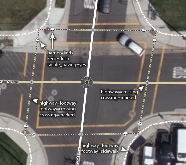
| 114523301 | about 4 years ago | Le due cose non si escludono a vicenda, la way è un dettaglio aggiuntivo: "For detailed mapping it may be useful to additionally tag ways leading from a sidewalk to the crossing node with footway=crossing or cycleway=crossing as appropriate." Esempio della Wiki: osm.wiki/w/images/5/50/Marked_crossing_example.png Sei pregato di non cancellarne altri. |
| 114337824 | about 4 years ago | Ciao ross-map, node/9187301074/
hai inserito lo stesso ref:msal in due farmacie differenti, puoi controllare? |
| 114530149 | about 4 years ago |
Perché hai cancellato l'alt_name? |
| 114448518 | about 4 years ago | About barangay=Capaya II, the standard is to add the barangay as a place=* tag, even better if as an area, so a POI can be tagged as addr:place=Capaya II. But it's not needed here since there's already addr:street. |