OpenStreetMap logo OpenStreetMap

barefootstache's Diary

Recent diary entries

Foreword

In ‘week 60 of 100’ wrote about an OpenStreetMap exploration session with the bike and from it I realized that a machete would help to traverse through the off-trail scrub portions. This fact I ignored, mainly due to the reasoning of being early in plant’s yearly life cycle, thus the green matter would not be as intense. This intention held true, though the hard matter still persisted and without hard duty gear, navigating through thorns one can become injury prone with scrapes and/or punctured clothing. Nonetheless since these obstacles are expected, the attitude attacking these are not as dire as when it is unexpected.
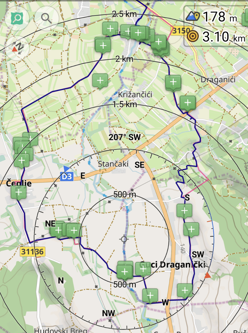
Route planning

(The red line is the planned route whereas the dark blue is the tracked one.)

The red line is the planned route whereas the dark blue is the tracked one within the OsmAnd app.

The planning (route in red) is done in such a fashion that one can grab a big portion of unmapped sections in one swoop. As one sees, the NW section off the D3 primary highway is missing landcover information, which gives an eerie feeling when trotting along the tracks.

Further one tries to avoid any large detours and tries to predict if one of the potentially ending paths actually is not an instance of noexit, though continues. Of course if the prediction is false, then one will get to deal with an obstacle (which was described earlier).

Obstacle: stream crossing

Two streams merge together while being guarded by a section of scrub

On the map the tail of the path ended with this lovely obstacle. On the other side of the stream there is track that follows it, so the prediction was made that there should be some kind of crossing. This is not the case.

The trickiness of the circumvention of this obstacle is getting back out of the canyon, since the walls are at least 2m tall with poor grip surface potential, since it is a sandy bank. Luckily the entrance to the stream is easily feasible, because there is no steep wall to disembark.

Two attempts in getting across the stream

Attempt 1

In the first attempt, the idea is to get to the island, which was straightforward and follow the second stream to see if there is a better spot to tackle it. Though when traversing back up from the water, it was blocked by a thick wall of thorns, so went back to the first stream crossing.

Attempt 2

Going back out where I came from and following the stream upwards was not a choice, since there was no information how long that would take. Thus the only choice was to go fully into the second stream. While wading through it, got surprised by a 1.2 m drop off, which lasted for only a couple of meters before shrinking to only a couple of centimeters.

Obstacle summary

Highlights of OSM changes: add 'noexit' to path tail; add missing stream

Right off the back, I added noexit to the path tail to avoid the future chance of navigating there. It might feel weird to add such tags to paths or tracks, though for cross country/off-trail navigation it can make a huge difference. Additionally, it helps me to give a visual guide of which highways I have already navigated to the end.

Further, more times than not, one can expect scrub to have a waterway. This can either be a stream or a ditch. In either case this makes the already difficulty obstacle a fun wet mess!

Obstacle: river crossing

Steel bridge for pedestrians with an one-side railing over a river

Other times the map tells you that there is a bridge for the track, but it is actually a ford. Nonetheless there was this pedestrian bridge close by.

Obstacle summary

Highlights of OSM changes: add foot bridge; add path; change track bridge to ford; add ditch; add bench

Notes are added there where potential obstacles exist like the two various river crossings: one time via the track which is a ford instead of a bridge, and other time the newly discovered pedestrian bridge. Further details of future paths is also added as potential future exploration session, which has the potential of discovering another waterway crossing. And finally adding minute details like a ditch, which pedestrians can easily overcome vs a motor vehicle.

Obstacle: traverse through the forest

(As refresher, the red line is the planned route and the dark blue is the tracked one.)

Planned red route differs from the tracked dark blue route which does serpentine instead of the straight red one.

It should be highlighted that the forest is on a slope of a hill with the incline going up, so the vineyards and orchards are on the top of the hill to the south.

The planned route was not possible, since along the residential highway is a barbed wire fence and there is the chance og having unexpected spectators from the detached buildings. Thus first went east to get to the forest to avoid any potential trespassing confrontations.

This is where I was met by a stream, which was not mapped and on the entry side has a 2m drop to the water. Getting my feet wet is not the issue (as previous described), rather finding a spot that has the least potential of causing injury. Found a tree that was used as a brace to let me slide backwards into the stream.

On the other side of the stream I was introduced by a path (maybe just a deer path), that I will definitely explore again in the future. Likewise the stream also needs better GPS data, since the outlet is unclear. The path was quite well marked and sometimes there were some tight fit spots like when multiple logs fall on top of each other or a small wall of scrub. This would have been the second scenario where a machete would have been useful.

Future thoughts

Exploring the country side is not for those who like the comfort of civilization. One should expect to be challenged against one’s comfort zone which this diary entry hopefully highlighted. Thus one should prepare for the worse possible scenario either physically, mentally, and/or have the appropriate gear for the task at hand.

All tools used in the field were used in airplane/offline mode. SCEE for existing objects (not highlighted in this entry), OsmAnd for note taking (schema used for note taking), navigation, and route planning. FitoTrack for track recording with a custom workout: rucking with 45 lbs.

Location: Hudovski Breg, Čeglje, Grad Jastrebarsko, Zagreb County, 47201, Croatia

Let’s take a look at addition and division mapping of natural and landuse. First we will look at the inconveniences that exist when mapping such areas. Next we will look at the method behind division mapping and scenarios of how to apply it. And finally take a real world example of how these two mapping styles were applied.

The definition of addition mapping is the act of adding new data to a white spot area aka an area with no data.

The definition of division mapping is the act of taking an existing object and dividing it down into smaller partitions.

Inconveniences when mapping natural and landuse

There are two main inconveniences when mapping natural and landuse from aerial imagery. First, depending on the resolution of the imagery, deciding where to make a clear cut if it is a distinct natural or landuse area. And second, the amount of clicking required to create a new area.

For the first inconvenience, more or less, it is personal choice and level of details. E.g. try to answer this question: when would one make a distinction between natural = scrub and natural = wood? The difficulty exists in the fact that the value scrub permits trees and lots of time these trees are/aren’t growing close enough to each other.

For the second inconvenience, lots of editors have the option to split a way (aka division mapping). In JOSM you can split an area with ALT+X (UtilsPlugin2 required). Or manually split the circumference of an area at two nodes and then separately connect the two arcs.

UtilsPlugin2 - Split Object tool

Let’s say one needed to create 4 square farmlands in a grid layout. How many node clicks are required?

Mapping the traditional way (aka addition mapping) 16 node clicks are required. One square has 4 nodes, and there are 4 squares, so 4 * 4 = 16.

Mapping with UtilsPlugin2, it takes 8-10 node clicks. There are two methods to achieve this. The first step is equivalent for both methods by drawing the circumference which is 4 node clicks.

Method 1

  • Draw the half line of the circumference which is 2 node clicks and split it in half with ALT+X. Now one will have two rectangles.
  • Repeat the process on both of the rectangles, 2 * 2 = 4.
  • The total node clicks is 4 + 2 + 4 = 10.

Method 2

  • Draw the one half line of the circumference which is 2 node clicks.
  • Draw the second half line of the circumference which is 2 node clicks, so that the two half lines make a cross.
  • Select the two half lines and SHIFT+I to add nodes at the intersection. This in return will already select the one node.
  • Select one of the half lines and P to split the way.
  • Now select the larger of the half lines and ALT+X and do the same with the smaller ones.
  • The total node clicks is 4 + 2 + 2 = 8, (though more interaction with the keyboard and lines is needed).

In this simple example there is already an improvement in node clicks. Next we will look at splitting larger areas.

Splitting a large area

Let’s say there is a 200 node circumference as circum# and one needs to split it in half. Let split# be the count of nodes for a split line with the minimum being 2.

Scenario 1

With the UtilsPugin2 one just needs to add the split line with a minimum of 2 node clicks, select it, and execute ALT+X.

Total node clicks are split# (minimum 2).

Scenario 2

One does not have access to UtilsPlugin2, which is the case when not using JOSM. Thus choose the two nodes where to create the split of the circumference at. Then draw the split line and connect it to one of the circumference halves and do the same thing for the other half.

Total node clicks are 2 + 2 * split# (minimum 6).

One is not familiar with the split methodology and thus one starts the area anew (not recommended since the history of the nodes is lost). Draw the first area which has split# + circum# / 2 node clicks and do the same for the second area.

Total node clicks = 2 * (split# + circum# / 2) = 2 * split# + circum# (minimum 204).

Planning on how to map natural and landuse

Let’s say one is mapping in an area that already has existing natural and landuse areas. One should plan ahead of how to map the white spots, since one can predispose oneself to inefficient mapping.

Let’s take a look at this animation of natural and landuse contribution in Croatia.

Before and after animation of natural and landuse

Area A shows white spot mapping, where as area B shows the split method.

Choosing the correct tool for the circumstance

From above we learnt that JOSM can handle both area A and B, though the downside of JOSM is that it is PC bound. On the other side Vespucci can handle also both, but being less efficient for B compared to JOSM.

Thus to min-max one’s daily living, if one commutes or has other spouts of down time, one could use the time to map via Vespucci, especially the A areas, since these areas are fairly straightforward and mundane to map. And once one has access to a PC, one can take upon the task of splitting up the newly mapped areas like in B.

Conclusion

In conclusion there are two ways of contributing natural and landuse data, either by addition (seen by white spot mapping) or through division (seen by the splitting method).

Location: Bencetići, Mjesni odbor Mrzljaki - Goljak, Municipality of Draganić, Karlovac County, 47201, Croatia

Taking a brief look at the Croatian country side, one will notice that lots of the tracks/paths end without an exit. Additionally, when navigating at location, one will realize that only a fraction of such highways exist on the map.

How to plan a route for exploring?

The amount of exploration sections should reflect one’s physical capabilities. In the beginning about one exploration per route should suffice and can be increased through practice and knowledge of the area. One shouldn’t bite off a bigger chunk before one can handle it.

In this example of about 16km route

16km route throughout the east hills of Zorkovac, Croatia

I chose one exploration section every 5km in such a matter that not more than 500m of distance was needed to be explored.

There was one section in the north that was an easy gravel highway connection,

Before and after animation of adding a gravel track onto the OSM

one in the east as a grass track,

Before and after animation of adding a grass track onto the OSM

and one in the south that was a dead end (03-05).

Before and after animation of updating a track and adding a dead end path onto the OSM

What to expect on the route?

Depending on the route on can be lucky by getting a well marked highway with no major physical barriers. Or one can be unfortunate and end up at a dead end.

In such cases, one can either turn around or dig into one’s adventurous side and tackle the obstacle at hand. This happened to me between 03-05.

Carrying the bike uphill to find a parallel path about 100m away

One can expect to tackle many forms of plant matter from the soft ferns to the prickly nettles and black berry bushes.

Hiding among the almost 2m tall ferns

Further one can use the helmet and bike to press away the plant matter to ease the possible injuries to oneself. Gloves will help a lot!

Squeezing the bike between the final trees just meters away from the path

And sometimes one needs to be creative of what the easiest way is to proceed.

It took a good hour to traverse those 100m between the two paths.

What gear should one take?

If exploring via bike, then obviously the bike and helmet.

Further - applies to hiking as well - gloves, sturdy shoes, thicker clothing to mitigate prickly plants, gloves, offline map, headlamp with extra batteries, extra layers of clothing, some food/snacks, and potentially a first aid kit.

What details are important to map?

The noexit = yes tag is important to add to such highways to inform the next explorer that there is no chance of getting anywhere further.

Further, adding path starts with the final node having the fixme = continue? tag. This shares a potential exploration route.

It is also wise to share the fixme = missing GPS data onto a highway, because often one can estimate where such highways exist through an impression line of forests/woods/scrubs. Though it could also just be a stream, so in person investigation is needed.

Want more pictures?

More pictures can be found on Pixelfed.

Location: Bošnjak, Zorkovac, Grad Ozalj, Karlovac County, 47286, Croatia

In Croatia some residential areas are well kept, while others are quite lacking. Example: Zadar vs Preko.

What to map?

This begs the question which entity should be mapped first with the largest gain for the effort? This can only be answered in the need of the beholder. For a tourist it would be street names, since accommodations are bound by an address and after the town name, the street name is the next factor to reduce the search area of the location.

There is a major requirement for this to fruition and that is that the town has to have varied street names. Depending where in the country one is traveling, it is quite typical that the street names are equal to the town’s name (e.g. Lazina). In such a situation latitude/longitude coordinates should be a requirement of the host to provide over the house number, because lots are not linearly arranged. Plus lots of such towns don’t have house numbers and/or buildings on the map.

Where are the buildings?

Lots of towns have buildings, though these are usually only a fraction of what actually exists. E.g. in Preko:

OSM data in JOSM depicting the lack of buildings mapped although the aerial imagery shows otherwise in Preko

Additionally, if the town has narrow pedestrian zones, one can expect that lots of buildings are missing and/or misaligned. e.g. in Komiža:

OSM data in JOSM depicting the misalignment of buildings in shape in Komiža

Narrow street in Komiža

Narrow street in Komiža

Mapping such towns are tricky without good aerial imagery and it might worth the investment to get a drone for such scenarios.

How to help map such towns?

GPX/GPS tracks and notes with street names help greatly. Notes can easily be made and shared on StreetComplete/SCEE. One should add the start of the street and at least take a picture of street name sign, if one is not willing to type it out.

Personally, I try to add the highway value and the compass direction to the note. This helps when the aerial imagery is to get an approximation of its presence on the map. E.g. in Komiža:

A set of notes in Komiža to help with street directions and names

Hint:

Change the keyboard layout to the language at hand, so in Croatia it would be Hrvatski. This eases the pain of getting their special characters.

What’s with Wikipedia?

Lots of the entries do not exist in the native tongue (e.g. Hum and plenty more do not exist in English (e.g. Žena Glava translates to wife’s head).

Tried to do site seeing via its information and was disappointed when the promised wasn’t there (e.g. Califfi Castle).

POI and existing data quality

To my surprise there was a good chunk of existing data with e.g. surface information of the roads or if benches have backrests. This is good news and most likely OSM’ers were there on holiday and maximised their StreetComplete contribution. So if more entities existed, data coverage could be quite quickly covered over the next couple of tourist seasons.

The interesting part of the POIs is that they were denoted in the native tongue of the mapper e.g. French or Hungarian and rarely in English.

Next steps

The next steps would be:

  1. Get the data on which towns see the most tourists.
  2. Go through the list and see what is the highway coverage, map ideally all roads.
  3. Go through the list and see what is the building coverage, map buildings around the main market square first.
Location: Komiža, Grad Komiža, Split-Dalmatia County, 21485, Croatia

This week continued working on the barefootstache-mapping-croatia project to align with my upcoming trip to the area.

While mapping east of Vrbanci, I noticed that I was almost done with its boundary and completed it.

before and after animation of OpenStreetMap depicting land cover addition mainly farmland, meadow, heath, scrubs, wood, and many other land covers

Quick Overview

3046 node changes in 18 change sets making an average of 169.222 per change in JOSM

Location: Lazina, Mjesni odbor Lazina - Franjetići, Municipality of Draganić, Karlovac County, 47201, Croatia

Tree mapping is a task that is better done in person than using aerial imagery, unless it is a tree row. The reasoning being that node placement of natural=tree is more precise than looking from above, since more often than not the imagery is not that clear.

Trees tell a story

When looking at this area it is fascinating how one can make out man made structures relative to the placement of trees.

trees and tree rows as nodes and ways in JOSM

Further once adding the leaf_cycle and leaf_type one can create shade maps that could be practical during heat waves like at mapasdesombra.org or if jveuxdusoleil.fr extended its algorithm to include tree details as well.

One can add the tree’s height and diameter with a check date to create a timeline of the tree’s lifespan, though also add more potential data points in ecological terms.

Or one can add the genus and/or species to ease the search for foragers like mundraub does with their overlay map.

Tree specification

Some tree genus are easier to identify than others like Acer or Quercus, though others are a bit trickier like Aesculus vs Castanea or Betula vs Populus.

Recently discovered that the simple distinction between Sorbus and Fraxinus (Mastodon) disregards the Acacia, Aralia spinosa, and Robinia trees.

Quick Overview

created by JOSM with 780 node changes in 5 change sets with a mean of 156; created by SCEE with 193 node changes in 26 change sets with a mean of 7.423

MappingChallenge - Week 54 of 100

Posted by barefootstache on 27 August 2023 in English.

It has been just over a week that I have accomplished the 365 daily MappingChallenge (Mastodon) and decided to persist with a 100 weekly challenge instead. One of the main (Mastodon) reasons is how daily contributions are being processed based off of UTC+0, which is manageable if one does not travel. Further this week I have decided to use the OSM Diary over Mastodon, since this way I can do long form entries with less constraints and possibly reach a larger audience.

Quick overview

In week 54:

  • 34 change sets created in total
  • 5327 node changes in total

all were done within JOSM.

Changes

  • extracting sidewalks from roads
  • splitting up schools
  • adding roof shape and roof material

Puchheim Realschule and Gymnasium

Location

Before and after animation of building geometry changes of a school district

Puchheim Mittelschule and Grundschule

Location

Before and after animation of building geometry changes of a school district

100 Day Mapping Challenge

Posted by barefootstache on 25 November 2022 in English.

For those who have been following my daily progress on Mastodon, here is the summary.

Data Collection

  • StreetComplete: each quest
  • OsmAnd: each POI
  • Notes: each note
  • SOTM22: each talk
  • droneImages: each image
  • OSMTrace: each trace
  • WikiData: each image for WikiData
  • vespucci: each changeset
  • idEditor: each changeset
  • JOSM: each changeset

First 50 days

Graph shows how often an app was used and what average changes were

During the first 50 days I was mainly doing the challenge remotely, which can seen quite well that a lot of mobile apps are present.

Second 50 days

Graph shows how often an app was used and what average changes were

During the second 50 days I was doing the challenge from home, which can see quite well that JOSM is the main app used.

Total 100 days

Graph shows how often an app was used and what average changes were

On days that I mapped with StreetComplete, I usually also used OsmAnd, and sometimes also vespucci if OsmAnd couldn’t solve the issue.

Most the time I was either mapping with OsmAnd or JOSM. Lots of times, I had a backlog of OsmAnd POIs, which I would deal with on days that I couldn’t actively map.

Graph shows the amount of apps used per day

Towards the last 10 days of the challenge, I became quite lazy, where on one day I just mapped on building on JOSM. Usually I would let the OpenAI run and add a cluster of buildings.

Conclusion

The first 10 days I started off strong and it mellowed out from there. It definitely has become second nature to map daily even if it is adding just one new POI or building.

Lots of times it was last minute mapping like in the last 10min of the day, just making any changes. Just so that the streak doesn’t break.

Future

The challenge will continue for at least another 100 days. Luckily with the game Munich S-Bahn Roulette I am introduced to a new area that is sparsely mapped with StreetComplete. So plenty more areas to go!