WalkerB's Comments
| Changeset | When | Comment |
|---|---|---|
| 102907548 | over 4 years ago | Dear Rohullah, Thanks for contributing to the map in Afghanistan. I see you're putting in a lot of Buildings overlapping buildings. This topological issue reduces the usability of OSM, and is incorrect. Here are some materials on the digitization of buildings: https://learnosm.org/fa/coordination/remote-tracing/ I'm happy to hold a mapathon and work with you and your friends and colleagues on this. Best, Walker |
| 86846045 | over 4 years ago | Hi Andrew, Thank you for contributing to OSM Afghanistan. I just wanted ot reach out and let you know that the Maxar Imagery is a little newer than Bing in Afghanistan. Thanks! Happy Mapping, Best, Walkre |
| 102722871 | over 4 years ago | Dear Rohullah, Thank you for contributing to OSM. I'm confused by the tags you have used here. Building=household is not one of the accepted tags by OSM. Maybe you mean place=plot? place=plot Here are the generally accepted building options: osm.wiki/Buildings#Building Could you please correct your tags? Thanks! Best, Walker |
| 95104905 | about 5 years ago | Thank you so much for cleaning up the roads data in Afghanistan. We really appreciate it! Best, Walker |
| 93361323 | about 5 years ago | Dear Taha, Thank you for improving the map of Afghanistan! I'm writing to you today to say that the "maxar premium" imagery layer is newer than "Bing" and often a little clearer. Take care and happy mapping! Best, Walker |
| 93117686 | about 5 years ago | Hi there. Like the ones in Iran, are you using Maxar Premium? It is the newest imagery in Afghanistant. Best, Walker |
| 94535871 | about 5 years ago | Hi there. Thank you for contributing to OpenStreetMap! I'm trying to find the roads that you placed, but i do not see them on imagery anywhere. Can you please tell me which imagery you are using? Maxar Premium layer is usually the most up to date. Are these new roads? Best, Walker |
| 87662626 | over 5 years ago | Dear Ratrun, I see your imagery source is Bing. Bing imagery for Afghanistan is very very old. You may want to check Maxar Premium for the newest imagery. Best, Walker |
| 81635276 | almost 6 years ago | Dear Mohaqeq, Thank you so much for your work! These look great! If you want to check out some additional resources, check out https://mapwith.ai/ Using that we can add many many roads to the map quickly. Thank you for helping make the map of Afghanistan the best it can be! Warm regards, Walker |
| 81397338 | almost 6 years ago | Dear Hassanpoor sb, Thank you so much for contributing to the map of Afghanistan! I see you’re using the ESRI imagery. You may want to use Maxar imagery, I think it’s a little newer! Happy mapping! If you want any help please let me know. Maybe you want to join the Facebook group OpenStreetMap Afghanistan. Best, Walker |
| 81106926 | almost 6 years ago | Dear Mohaqeq sb, Thank you so much for adding so much to map of Afghanistan. I noticed that many of the buildings are not actually "buildings" but are compounds, some of which include orchards and other agricultural goods. Perhaps these could be changed to "residential" land use instead of buildings? If you go that route, it might be much easier and faster to tag the whole area rather than the individual compounds. If you haven't already, please join the Afghanistan OpenStreetMap group so we can all chat more and coordinate. Likewise the actual buildings (not the whole land use areas) don't have square corners. In OpenStreetMap, we prefer to have the buildings have nice square corners, in ID editor and JOSM this is done through the "Q" button, but the overall polygon is selected. When you get a chance, if you could go back and start retagging the areas with area features, and only the physical structure as a "building". Thank you for your contributions and for making the OSM for Afghanistan the most accurate it can be. Slowly slowly we will build the whole map! Kind regards, Walker |
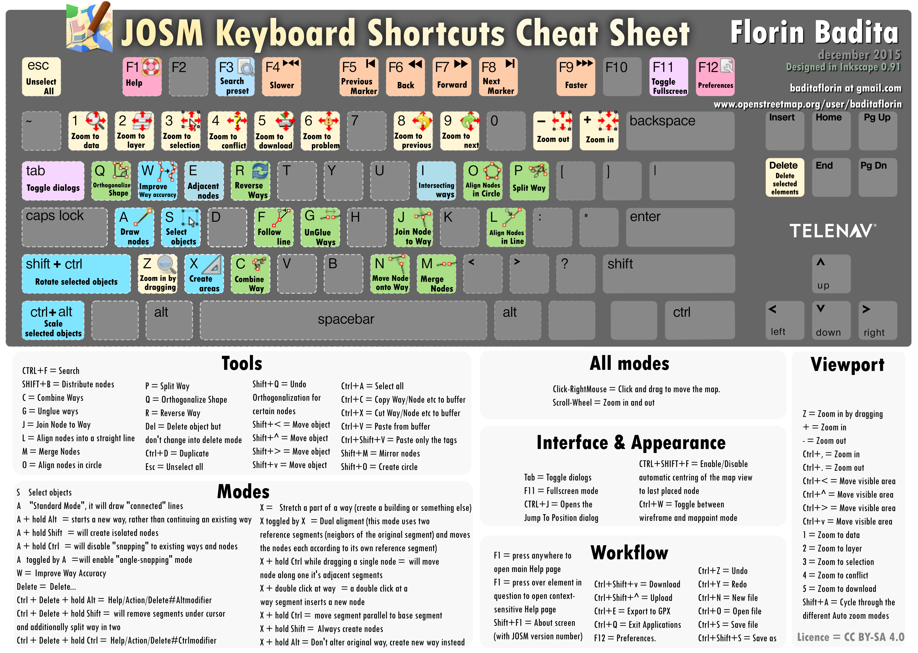
| 75701680 | about 6 years ago | Dear Jafary sb, Thank you so much for making the map of Afghanistan the best it can be. I have two points of feedback for you. The first is that Bing Imagery is very old, you may want to use Maxar Premium, it is much newer! The second, is that when you make buildings, after you add the building select the building and press "Q", to make the building with nice corners. Here is a "cheat sheet" for JOSM: osm.wiki/w/images/9/99/JOSM_Keyboard_shortcuts_cheat_sheet.png Happy Mapping!! Best, Walker |
| 76340675 | about 6 years ago | Dear Hassanpoor, Thank you so much for contributing to the map of Afghanistan. I noticed on some of you buildings, they corners are not square. After you digitize a building please select it and hit "q" in both ID editor and JOSM, this will put nice corners on the buildings. JOSM also has the validate button which will show many of the errors. Best, Walker |
| 75794821 | about 6 years ago | Dear Afnui, Thank you so much for your work on the Map in Afghanistan! We really appreciate all your help. We are interested in growing the OSM community in Afghanistan so if you're interested we have a Facebook group for OSM Afghanistan. Happy Mapping! Kind regards, WalkerB |
| 75754999 | about 6 years ago | Dear Hassan, I hope you are well. Thank you so much for your work on OSM! I noticed that you used BING imagery, you may want to use Maxar Premium because it is usually newer. I've found that Maxar Premium and ESRI Clarity Beta are usually the best. One final note, you may want use the hotkey "Q" to square the buildings so they have nice sharp edges. Just curious, for what organization are you doing this for? I will try to connect your areas to the road network. Best, Walker |
| 75761717 | about 6 years ago | Dear Jafary sb, I hope you are well. Thank you so much for your work on OSM! I noticed that you used BING imagery, you may want to use Maxar Premium because it is usually newer. I've found that Maxar Premium and ESRI Clarity Beta are usually the best. One final note, you may want use the hotkey "Q" to square the buildings so they have nice sharp edges. Just curious, for what organization are you doing this for? Best, Walker |
| 74113388 | about 6 years ago | Salaam Walaikum Sharifullah. Welcome back! Thank you for adding the roads to the map! I see you're using Bing Imagery, you may want to use Maxar Imagery. It is better. You can change this by selecting "Background Settings" on the right side of the screen and selecting "Maxar Premium". |
| 52255464 | about 6 years ago | Thank you for adding this data to the Map. Your contributions help make a better future for all Afghans. |
| 74765247 | about 6 years ago | Salaam walaikum! Thank you for your work on the map of Afghanistan. Your data helps improve the lives of all Afghans. I see you used Bing Imagery, you may want to use Maxar Imagery, it is a little newer than Bing. You can access it in the editor, by selecting "Background settings" on the right, and then selecting Maxar Premium. Thank you so much! |
| 74000667 | about 6 years ago | Salaam Walaikum! Thank you for your work on the map of Afghanistan! You may want to use Maxar Imagery instead of Bing. I think it's a little newer. You can change image source under "Background Settings" on the right side of your screen. Keep up the good work! |