I’m a bit behind the times with smartphones. I only got my first a couple of years ago, a small-screened, low-powered model on a cheap-ish contract. It did the job, but I recently upgraded to a far more powerful, larger-screened model with 4G capability and WOW suddenly I’m finding I can do all sorts of cool things. One of those things is OSM-ing on-the-go with Vespucci. I’d heard about it ages ago but dismissed it (who’d want to fiddle around with a phone when you can sit at home with JOSM?), but I installed it recently and it’s brilliant. Smooth, intuitive, & great features like the “recall last tags” button and the fact it won’t let you download new areas without finishing off the last area. I’ve become a father recently so don’t have time for long hikes in the country right now, so instead I’m doing small things like POIs and addresses whilst walking to the station, and uploading them via Vespucci on the train to work. Perfect.
Pgd81's Diary
Recent diary entries
Is it bad form to write 2 diary entries in one day? Possibly. But the network drives in the office have conked out, and it’s Friday afternoon, and I have this all ready to go, so what the hell.
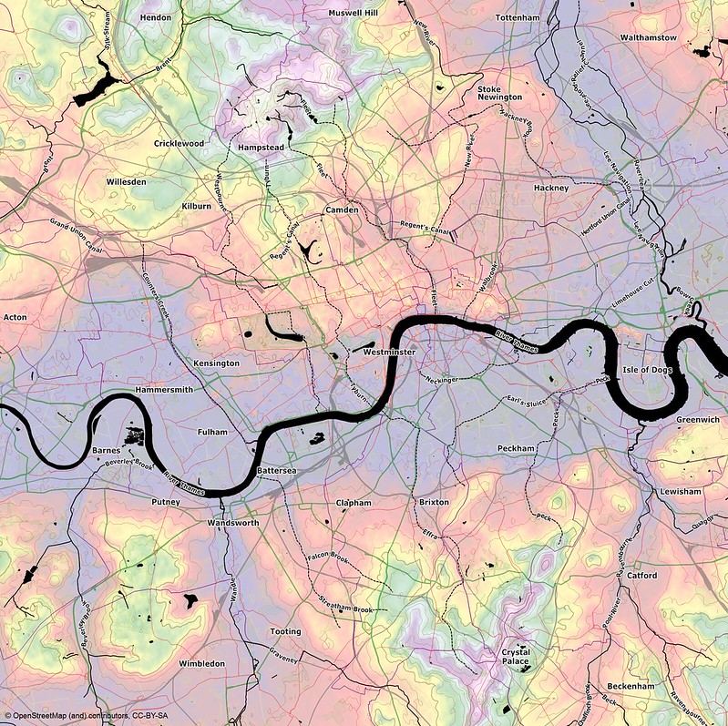
London’s lost rivers have fascinated me ever since I first read about them, and since I started cycling in London the contours have fascinated me too. Finding a way to visualise these things was what first got me into OSM (via Maperitive), but I never found the time to finish the job to a reasonable standard. So here’s a first attempt, see what you think:
Croydon takes a lot of stick – it was heavily bombed during the war, with any remaining traditional aesthetics being destroyed in the ’60s under a council masterplan to establish it as a centre of commerce. It’s a “working-class” town in unfashionable South London, with high levels of poverty, and of course was hit by rioting in 2011.
But it’s also cheap (for London) and easy to get around, generally friendly, and has various places of interest if you know where to look. It also has a number of local blogs and webpages, including the excellent Completists’ Guide run by Kake Pugh (http://croydon.randomness.org.uk – a sometime OSM contributor herself I think). As you can see if you click through, it’s a treasure trove of POI info. So instead of gathering POIs from scratch, I’ve been able to print off details from the site to take with me on surveys, making notes where needed (kinda like Walking Papers). I’ve now added building and shop info for all of central Croydon, with only London Road (aka West Croydon aka Broad Green) to go.
With a new shopping centre and various “public realm improvements” planned, hopefully the town is on the up, and maybe OSM (and the Completists’ Guide) can help in some way, who knows.
I recently surveyed the main paths at Croham Hurst, a tree-covered hill with two bare caps at the peak. It’s a beautiful, peaceful spot (and designated SSSI) just minutes on the bus from Croydon high street.
Anyway, my instinct was that, since the wooded area doesn’t accurately define the actual area called Croham Hurst (not only are the peaks bare but the wood extends slightly over the outer boundary), I should use a multipolygon for the wood, and a separate, overlapping area to define Croham Hurst itself. For want of anything better (there isn’t an establised tag for SSSIs/protected natural areas/etc I don’t think) I tagged it as “leisure=park”. But on Mapnik that made the woods render in a yucky greeny-turquoise. I know about “tagging for the renderer” but still, I wondered why it was happening, and whether it was partly a substandard choice of tags.
In the end I got inspiration from the nearby Addington Hills, tagging the “holes” as “natural=heath”, and replacing “leisure=park” with the generic “area=yes” (with a Wikipedia link describing what the site actually is). I’m certainly happy with how it renders – but hopefully fellow mappers will be happy with how it’s tagged!
I have a friend who is Charlton Athletic fan, another who has a flat round the corner from the ground, and another who generally loves football (I should probably admit that I’m not that bothered, personally, though it makes for a fun afternoon out once in a while). So last weekend we rocked up for CAFC’s League One championship winners’ kickabout against Hartlepool United.
I purposely arrived a little early, to give me time to explore Charlton House and village. I’d passed through the park before whilst walking the Capital Ring, so I already knew it vaguely, and a glance at OSM showed me very little detail in the area. So I had a quick walk around the place, making a mental note of what things were where, and added a bit of new detail to the map over the rainy bank holiday.
osm.org/?lat=51.480751&lon=0.037575&zoom=18&layers=M
There’s plenty more to do, though – maybe I’ll do a little more next time I visit my friend.
Hi there, new user in South London (Croydon) here.
I’ve been a map-geek pretty much all my life, but although I’ve been aware of OSM for a while I figured it was beyond me, especially with a fairly rubbish PC and no GPS.
The spark that persuaded me to jump in was when I started cycle-commuting and thinking more closely about the geography around me, particularly hills. But I couldn’t find any decent London topography maps. This guy’s excellent but limited use of Google’s data got me wondering if something similar could be done with OSM, and this article showed me that yes, it could, and a whole lot more. I installed JOSM and Maperitive and had created what I wanted by the end of the evening. So simple! So of course then I had to join OSM properly :)
I’m also a keen walker with a young son, and I like exploring my area’s more obscure parks to see what’s there. I’ve noticed there are a lot of parks in South London that are just blank spaces, waiting to be mapped. I don’t have a GPS right now but I can visit them, take pics, and do my best from Bing imagery. I hope to get a GPS soon so I can check my work so far.
Thanks for reading, and happy mapping! Dave.