Nico D's Comments
| Changeset | When | Comment |
|---|---|---|
| 153950195 | Hola, gracias por tu aporte!
|
|
| 153948805 | Hola, gracias por tu aporte!
|
|
| 153921325 | Hola, gracias por tu aporte!
|
|
| 153947828 | Hola, gracias por tu aporte!
|
|
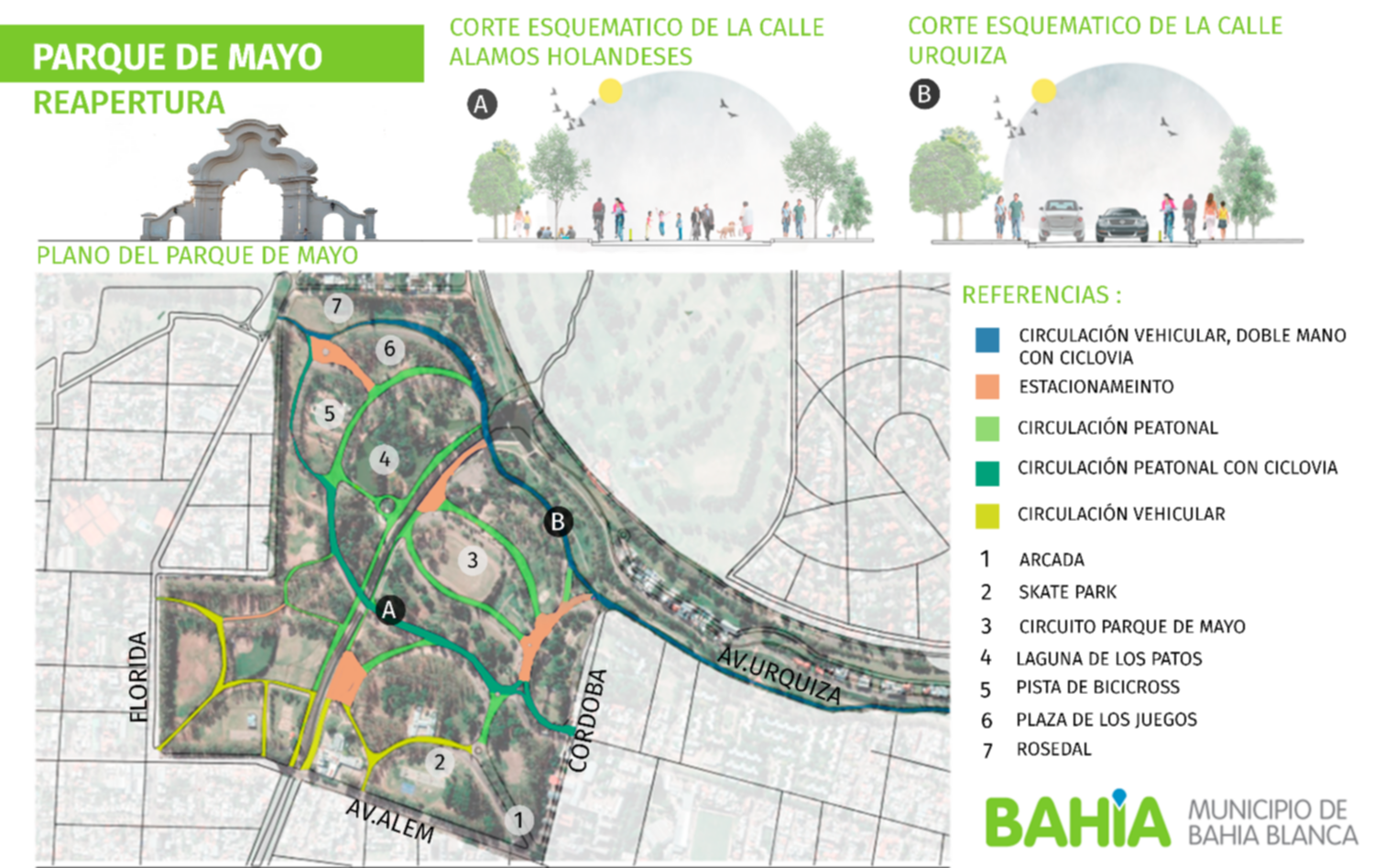
| 132989155 | Hello again, I see you are still active but you didn't respond to this comment. I have just reverted your changes (133112472). I've just been there and nothing changed. The streets are still only for pedestrians. I have also added some barriers I saw there. I suspect you are not from here, you saw roads in aerial imagery and you retagged them. If you had been to the park, and you had saw vehicles using those roads, and then you retag them. That would be perfect! But this was not the case. Or, if you hadn't been to the park but you had some reliable source that the cars can use those roads. Ok, that would be fine I guess.
Please, reconsider future changes (anywhere) if you can't survey the site or you don't have another source. |
|
| 132989155 | Hi there, do you speak Spanish by chance?
I understand that maybe the previous tagging was incorrect. However, I fear that this new tagging would route vehicles to enter and use Parque de Mayo using roads only for pedestrians. There is this news:
Also, I live in this city, I have gone to the park recently, and I've seen the different types of barriers to stop vehicles from using the Alem/Cordoba entrance and the 12 de Octubre entrance. I should have tagged them too. So, to sum up. What tag do you propose for the roads marked for pedestrians and bikes only? Maybe I'm not up to date and something changed. What source did you use to map those ways as service roads? Thanks. |
|
| 114592972 | Hola Pablo!
|
|
| 115144327 | referencias: https://www.lanueva.com/nota/2021-3-5-11-20-0-en-una-semana-se-habilita-el-transito-en-el-parque-de-mayo y https://px.cdn.lanueva.com/032021/1614953927288/lamian%20con%20arcada.png |
|
| 114833441 | *club olimpo |
|
| 99555655 | Hola! te doy la bienvenida a OpenStreetMap! Gracias por tus aportes a la comunidad :D Queria consultarte sobre este cambio. Veo que agregaste un espacio verde junto a la biblioteca bartolome mitre. Pero revise las imagenes satelitales de google y de bing, y tambien "el autito" de google y solo veo edificaciones, no parece haber espacios verdes.
yo vine a este cambio por el nombre que indicaste, ya que no se suele usar de nombre lo mismo que "la misma cosa". Ej a una plaza se la mappea con tipo "plaza" y no hace falta ponerle de nombre "Plaza", se le pone el nombre oficial. Quise buscar informacion sobre este espacio verde y no encontre. |
|
| 77739640 | Gracias :D No nos dimos cuenta que la numeración no era consistente con la calle.
|
|
| 77739640 | Hola! ¿Cómo estás?
|
|
| 76412069 | Para el registro, el cambio que se revirtio es este: changeset/76207018 |
|
| 76207018 | Para el registro, el cambio fue revertido aca: changeset/76412069 y se dejo alt_name con Perez |
|
| 76232302 | Genial Kcho! Te agradezco la referencia a La Nueva |
|
| 76207018 | P.D: agregue alt_name con Pirez, por ahora, si surge luego cual es el nomre oficial vemos como hacemos. changeset/76232302 |
|
| 76207018 | Hola! ¿cómo estás? Desde ya gracias por las contribuciones :D Sobre este cambio, vivo por la zona y he visto carteles que dicen Nicolas Pirez y vecinos de aca le han llamado Nicolas Pirez.
Entonces me pregunto, ¿Cuál es el nombre oficial? ¿Ambos? ¿Uno solo? ¿Vos en que te basaste para cambiarle el nombre? ¿Encontraste alguna fuente? No que este mal eh, para nada, solo que me queda la duda tanto personal como en OSM de que nombre es el oficial. |
|
| 65891450 | Las referencias me quedaron mal:
|
|
| 65523748 | referencia de la información:
|
|
| 48340360 | Hola, como estás? Te agradezco por las mejoras que realizas al mapa!
Se puede usar la siguiente página
Y también está la página particular de Argentina
Por último, te invito a unirte al grupo de Télegram "osm_ar" ( https://t.me/osm_ar ) :D Saludos! |