LucGommans's Comments
| Changeset | When | Comment |
|---|---|---|
| 146613156 | almost 2 years ago | Mij valt net op dat je het huisnummer ook verwijderd hebt. Waarom niet aangeven welk huisnummer bij dit restaurant hoort? |
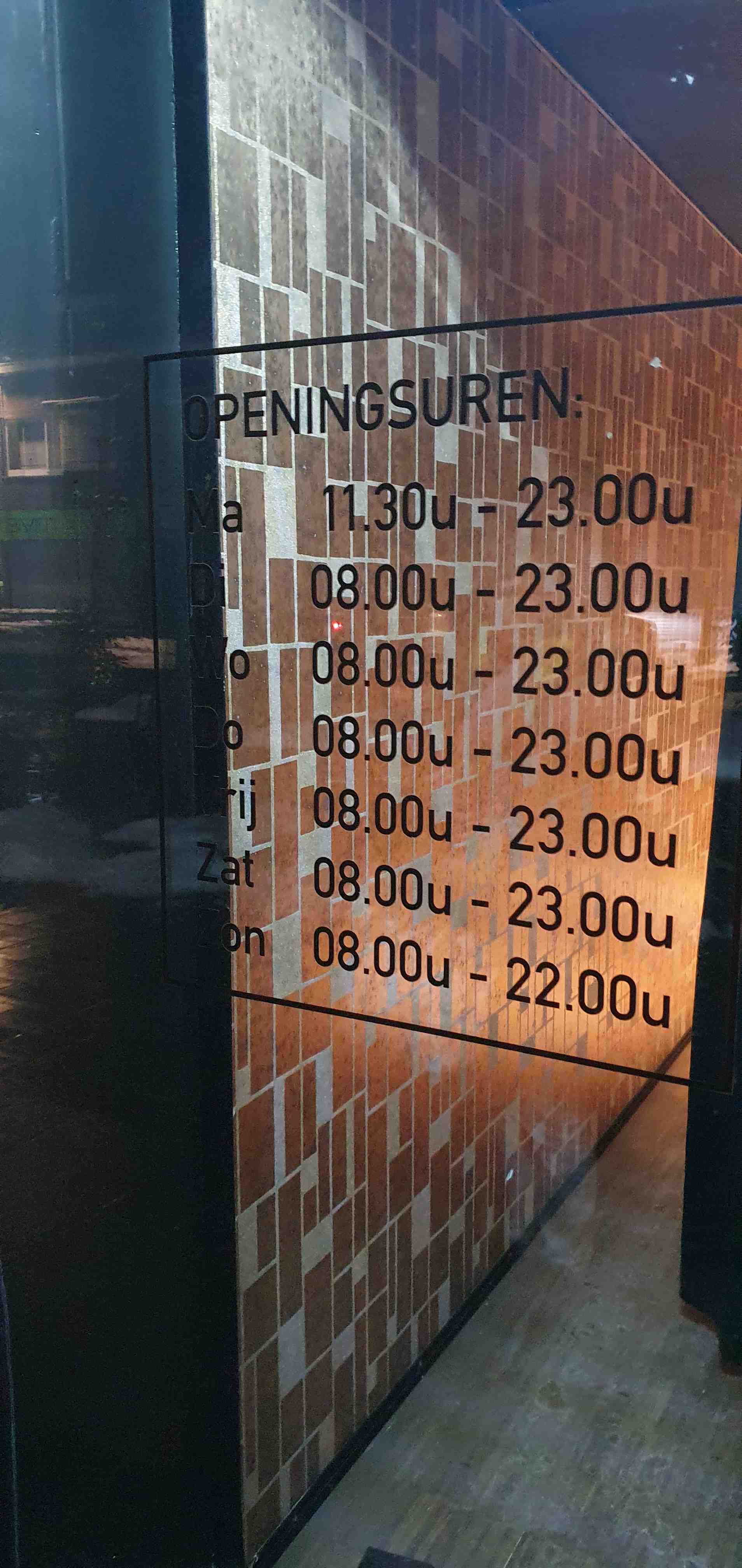
| 146613156 | almost 2 years ago | Ben enkele dagen geleden ter plaatse geweest, was inderdaad erg verward dat het aan de verkeerde kant van de straat lag! Haha. Heb toen een medewerker gevraagd of ze wel nog ijscoups doen en dat bevestigde ze. Vandaar mijn tagging als ijssalon, dat is hoe we het kenden (en wat bevestigd werd) en met de ongemakkelijk hoge stoelen en kleine tafels had ik geen aanleiding te vermoeden dat het uitgegroeid was tot restaurant waar je meer dan een ijsje en een drankje nuttigt. Dat ze nu ook echt eten hebben (lunch/diner) wist ik dus niet! Die menukaart hebben we niet gekregen maar 't was ook al laat dus de keuken zal gesloten geweest zijn. Thanks voor de correctie en het toevoegen van de website, dat is altijd handig om erbij te hebben inderdaad. De openingstijden"correctie" komt overigens niet overeen met wat er ter plaatse wordt aangegeven: https://lucgommans.nl/tmp/20240119_230823-puccini.jpg
|
| 145031806 | almost 2 years ago | Dus het wegje is er nog? Dan moet het niet verwijderd worden. Als het privé is, volstaat bijvoorbeeld access=no toevoegen aan de weg en/of de barrières/poorten |
| 117827256 | about 2 years ago | Hi! You added access=permit to this node node/4904045471 which has Kundenparkplatz in the name. Should this not be access=customer, or do you need to request a permit ahead of your arrival to be able to drive in? Thanks!
|
| 141521969 | about 2 years ago | Oh! Just checked how come I missed it, turns out it's there on osmand but only with some extreme zoom https://snipboard.io/HIWyAa.jpg :D Thanks for the hint! I have removed my duplicate |
| 44478795 | over 2 years ago | Hallo Thorag, I realise it has been over six years, but do you remember if the ice-age settlement next to the nature reserve "Im Korkus" was visible at the time? As in, any kind of excavation or artifacts at the site. When I was there, I only saw farmland. (Auf mein bestes Deutsch:)
Vielen Dank! |
| 135265538 | over 2 years ago | Sorry voor de late reactie, dingen zijn wat hektisch momenteel en ik had verwacht idd achter JOSM te moeten kruipen en me erin verdiepen om hieraan verder te werken. Maar ik zie dat je het al had opgelost! Dank :) |
| 136130461 | over 2 years ago | Oh, right! Thanks for noticing and fixing it! |
| 125898411 | over 3 years ago | Implemented in changeset/126031248 Thanks! |
| 110725614 | over 3 years ago | Hi Bestof, thanks for contributing to openstreetmap! I noticed that there is a sign on the sidewalk of Aachener Straße saying that the sidewalk may be used by cyclists. You tagged the road as cycleway=no (makes sense: there are no visual markings on the road), but it seems like the correct tagging for this situation would actually be cycleway=track. Cyclists can use a separated track (the sidewalk) for cycling along the Aachener Straße right after the traffic light. The tag cycleway:segregated=no can also be added to indicate that the space is shared with pedestrians (this sign is present: osm.wiki/File%3AZeichen_240_-_Gemeinsamer_Fu%C3%9F-_und_Radweg%2C_StVO_1992.svg ). Also on the L223 (way/319476907), there is a cycleway separate from the road (namely this one: way/131331611). For that, StreetComplete has a button to indicate that there is a cycleway that is separately drawn ("separat auf Karte eingezeichnet"). Hope this helps! Luc |
| 112826508 | over 3 years ago | Oh, sorry Andy it was indeed introduced in the version before your change. My bad! |
| 112826508 | over 3 years ago | Hi Andy, thanks for contributing to openstreetmap! I noticed that there is a sign on the sidewalk of Aachener Straße saying that the sidewalk may be used by cyclists. You tagged the road as cycleway=no (makes sense: there are no visual markings on the road), but it seems like the correct tagging for this situation would actually be cycleway=track. Cyclists can use a separated track (the sidewalk) for cycling along this road. The tag cycleway:segregated=no can also be added to indicate that the space is shared with pedestrians (this sign is present: osm.wiki/File%3AZeichen_240_-_Gemeinsamer_Fu%C3%9F-_und_Radweg%2C_StVO_1992.svg ). Hope this helps! Luc |
| 118990389 | over 3 years ago | Einige Bilder der Jetzige Situation: https://lucgommans.nl/tmp/osmpath
Also ich sehe keine Pflanzen auf dem Pfad, oder nun ja, nur was von sich selbst wächst, nicht etwas das angepflanzt aussieht für mich. Auch gibt es kein Schild das andeutet, dass man hier nicht laufen soll. Vielleicht war das Pfad geschlossen wegen die Bauarbeiten der neue Brücke. Jedoch stimme ich dir zu, dass die Wanderrouten besser auf das obere Pfad umgeleitet werden sollen. Es ist deutlich neuer und netter. Das meiste soll jetzt aktuell sein, außer den Relations: changeset/122587129 Ein zweites paar Augen, wenn du mal drüber gucken möchtest, schädet natürlich nie :) |
| 122150677 | over 3 years ago | 1 & 4: I don't doubt that ALKIS is official from the government (that doesn't make it correct) or that you managed to use Strg+C correctly (instead, I highly doubt that someone would call the place Glücksburgweg when there is a Weg called Glücksburg at walking distance to the north). 2: okay so others made the same mistake, is that a reason to continue? 3: not all points are historic, I'm sure many of them are also current, but you said yourself (and I agree) that, without local knowledge, it cannot be said which belong in which category. |
| 118990389 | over 3 years ago | Hmm, dann werde ich mir das morgen noch mal anschauen. Ich errinere mich nicht Bepflanzung gesehen zu haben, und bin mir sicher dass ich das untere Pfad genommen habe. Fortsetzung folgt :) |
| 122150677 | over 3 years ago | Thanks physi for the response and thanks Tux for the links! --- Tagging scheme --- I see the community is quite divided about whether these are useful, and even less sure about whether place=locality is a good tag. Adding these locality=ALKIS_Lage tags until we found a good tagging scheme, and then mass editing them later, sounds okay to me as a tagging scheme. Of course, this assumes that you then also make sure a suitable scheme is found (because you are the one that wants to add this), and clean up the temporary tags afterwards. Otherwise the temporary tags will just stay there forever. So far, I am not seeing a lot of participation to make this happen, but I do see you are continuing to add nodes on the map for more than a year since the discussions started. --- Currentness --- I see there is a post from physi in one of the threads, saying: "Inhaltlich bin ich der Ansicht, dass die Eintragung einer historischen Flurstück- oder Gewannbezeichnung dann sinnvollerweise erfolgt, wenn der Name noch gebräuchlich oder bekannt ist. Dazu sind aber sehr lokale Kenntnisse notwendig." This makes sense to me, so then we should stop copying these names from a database and instead use local knowledge, right? The ALKIS database might contain these labels in some "current" layer because it is the latest info it has available, but that doesn't mean people on the ground call it by this name anymore. It just means that ALKIS users might use the name to refer to the place. Copying labels from a database like this, without any knowledge of local use, seems similar to tagging what3words labels as localities. Maybe someone uses it, maybe not. In another changeset discussion (changeset/122333151) you wrote "Frage der Gebräuchlichkeit halte ich dagegen für relevant bei der Darstellung dieser Informationen". This is not true: the renderer can't choose that old names are irrelevant, because it's not labeled as an old name. If a place is only formerly known by a name, then the name=* tag is simply not accurate. For example Westerwald (node/9815156407) placed outside of a Wald... whether that Feld is still called Wald, is something only locals can say. --- Accuracy --- You haven't commented on the issue I raised above, where Camp Astrid allegedly is a locality called Glücksburgweg by the locals, while in reality there is a real Glücksburgsweg (and bus stop called Glücksburg) only a few minutes walking to the north. Not being from Germany originally, I cannot say whether the names near me are accurate, but this is one example where it seems clear that this ALKIS data placed a label in the wrong place. I don't know what the threshold is before OSM considers a data source reliable and suitable to copy from (even if there are, of course, occasional mistakes). It might be good to investigate ALKIS' currentness and accuracy before using it. --- Specificity --- Labels such as "An dem Rothenbach" (e.g. node/9816379762) obviously refer to an elongated area, namely the length of the brook called Rothenbach. Adding a locality here rather than a name or old_name to the brook would be more correct and help users a lot more to find something that is described as being "by some brook". Picking a random point and calling that place "by the brook" is not very specific. Since the brook currently has no name, if this is the brook that ALKIS refers to, then adding the name there would be a useful addition to the map! Similarly for the Eschweiler forest, where the Stadtwald is allegedly also called Gemeindewald, it would make more sense to add the loc_name to the existing Wald object (relation/106123) rather than adding a duplicate object to a few locations that are seemingly chosen at random (or for/by the ALKIS renderer). I would see this as a useful addition! --- Duplication --- "The repetition in some cases is due to the large area of that object. It is comparable to a long street which also uses the street name several times, not only once." That's because they indicate a defined region, from point X until point Y this road is called Hauptstrasse, and for technical reasons the way object needs to be split into multiple segments (to have different tags for different parts). This is not the same as adding duplicate localities for the same locality. If there are adjacent, duplicate locality names shown in ALKIS data, and it is known to be current and accurate, then one should add a single node at a suitable central point, rather than adding multiple nodes for the same place. (Update: while I was writing this, I see you added more changesets, and this one for example with even more duplication than I saw in past changesets... changeset/122553475 Please stop that, I really don't think this is correct.) --- Community --- Working together always requires communication and discussing with others. Aixbrick requested 10 days ago: "Bitte höre vorerst auf, Gewannnamen zu ergänzen." (changeset/122076044) Vademecum said: "Sich der Beteiligung an der Diskussion zu verweigern, wenn es um einen von dir erfundenen strittigen Value geht, finde ich im Rahmen eines Gemeinschaftsprojekts bedauerlich." (same changeset) flohoff wrote 3 days ago: "Lagebezeichnungen zu übernehmen die typischerweise ausserhalb des Katasters niemand benutzt macht IMHO keinen Sinn." but asked for discussion (https://forum.openstreetmap.org/viewtopic.php?id=75785) I think I also raised a few points that should give pause regarding adding more of these names from ALKIS. The OSM community can be conservative (particularly regarding imports) and we have to be weary of ossification or excessive bureaucracy. In this case, multiple people question the source (whether the data is good at all) and everyone seems to agree that the tagging scheme isn't good either. The latter is okay temporarily, if it can be machine-edited later, but more than a year is not very temporary. Because of the questionable source quality, combined with repeated requests from different people: you should stop adding more of these names, at least until the data source's quality is known (then we can still see about the tagging scheme and mechanically edit it). |
| 121582382 | over 3 years ago | Looks good, thank you! |
| 121582382 | over 3 years ago | Please see osm.wiki/Keep_the_history when updating objects on the map. This edit destroyed a reference on the german osm wiki, see "[1]" on osm.wiki/DE:Tag:place%3Dlocality |
| 122150677 | over 3 years ago | I just noticed another questionable locality name: Glücksburgweg (node/9805658383). That sounds like a street name to me, and indeed there is a street "Glücksburg" just to the north. Do people really call this field (that you placed the node into), or the greater forest or Camp Astrid area, "Glücksburgweg"? |
| 122150677 | over 3 years ago | Hmm, I'm seeing three places in the same forest all called Gemeindewald. That seems duplicate to me, considering this best practice: osm.wiki/One_feature,_one_OSM_element
I've also got doubts about adding places allegedly called "at the little street". This is not at all unique for a locality (osm.org/search?query=Am%20Str%C3%A4%C3%9Fchen) and there are also many real streets called as such (e.g. way/186657234). This will just muddle regular address searches and I wonder if anyone really calls a locality such a name. How do you see this? |