OpenStreetMap
Kerploonk's Comments
| Changeset | When | Comment |
|---|---|---|
| 184426102 | Hi, Yes, the road is toll-free for now, thus it is not appropriate to tag it as such to begin with. Vegaskrá is updated yearly, so the 2025 one is valid for the road system as it was in the end of 2025 (published start of 2026). At the time of this changeset I used an overview picture from Vegagerðin's website: https://www.vegagerdin.is/media/2026/06/hornafjordur_kaflar-copy.pdf This picture differs however compared to the actual data layer provided by Vegagerðin, updated after the road formally opened, which I corrected in a later changeset. The data layer also provides the hierarchy (road type) and name of each road, so it's more accurate than the overview picture. The data layer is available on https://kort.gis.is/mapview/?app=kort under "Vegir Vegagerðarinnar". Best regards,
|
|
| 183869184 | Sæl,
|
|
| 177227461 | Hello,
|
|
| 176235413 | *Speed limits* |
|
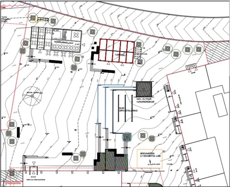
| 164001033 | Hi. They will be moving an existing historical building, Norðurpóll, to Hlemmtorg as part of the 5th phase of construction. The other building, Laugavegur 111, will house a playground "Hlemmur Leikhöll". Unsure whether it's an actual building, but it has an address. A part of Hlemmtorg after construction of the 5th phase can be seen here:
|
|
| 163173565 | Hi MissMarcoPolo, The updated ref tagging is based on Vegaskrá 2024, a public document in Icelandic published by the Icelandic Highway Administration (Vegagerðin), available for download from https://www.vegagerdin.is/samgongukerfid/vegakerfid/vegir .
The document is quite heavy and local knowledge is often needed to decipher the alignment of the roads. The data from Vegaskrá is also published as a GIS feature by LMÍ (National Land Survey of Iceland) under the IS 50 V set of GeoPackages for features in Iceland ( https://gatt.natt.is/geonetwork/srv/eng/catalog.search#/metadata/41D3314D-55AF-4FE3-9A9F-B9CB18AC5CAA ).
Cheers. |
|
| 158713069 | Svo voru nokkrar aðrar breytingar sem ég þorði sjálfur ekki að setja í gegn, t.d. 40 km/klst hámarkshraði á Hvaleyrarvatnsvegi, sem skv. listanum ætti að hafa 50 km/klst hámarkshraða en skv. götumyndum á ja.is og fyrri "töggum" er skiltaður með 30 km/klst hámarkshraða. |
|
| 158713069 | Var búinn að fara sjálfur í gegnum listann hjá Hafnarfjarðarbæ (https://hafnarfjordur.is/umferdarhradi-laekkadur-i-hafnarfirdi/)
|
|
| 156844141 | Changed on a legal level "city wide" that is to say |
|
| 156844141 | The street level imagery on ja.is is from summer 2022. In an announcement from Kópavogsbær March 2024 speed limits were reduced on almost all streets in Kópavogur. https://www.kopavogur.is/is/frettir-tilkynningar/breytingar-a-hamarkshrada
|
|
| 153472575 | The Icelandic Highway Authority (Vegagerðin) classifies all its roads into different hierarchical groups;
The road classifications can be found in Vegaskrá, which is a public document and can be used according to osm.wiki/Iceland .
I don't really know why designation is used. According to osm.wiki/Is:Map_Features , the tag "network" should be used to indicate the road classification. I have simply been following convention seen on other roads. |
|
| 152057006 | I'm fairly sure these restrictions do no apply to Akrafjallsvegur itself. Looking at the signs near the intersection of Akrafjallsvegur and Akranesvegur (https://ja.is/kort/?x=353234&y=428738&nz=13.52&ja360=1&jh=116.7) they all have a sign below stating an exception to the upper sign e.g. "No horses (upper sign) - í Hvalfjarðargöngum (lower sign)", meaning that the restriction only applies in the Hvalfjörður tunnel. |
|
| 151118501 | The name of this road is also Kambavegur on older plans, see deiliskipulag from 2007 below. While it is called Turnahvarf on the street sign, I decided to change the name in line with construction of a residential neighbourhood SE of Turnahvarf.
|
|
| 151118501 | I recently merged both segments in line with deiliskipulag (local plan) from 2023, see:
|
|
| 149633074 | *Ölkelduvegur |
|
| 147903812 | *147899600 |
|
| 145919036 | I was debating whether it should count as regional or local. I went with local since it's only on the agenda at Akureyrarbær, as opposed to the system in the capital (signed by most if not all municipalities there). |
|
| 145334841 | Source: https://straeto.is/skipuleggja-ferd/timatoflur/landsbyggdin |
|
| 144188671 | *Álftanes |
|
| 144150470 | Source: https://www.utu.is/wp-content/uploads/2023/07/8b.-Sunnuhlid_endursk.dsk_.-uppdr.pdf |