Eiim's Diary

Recent diary entries

It’s a pretty nice jump.

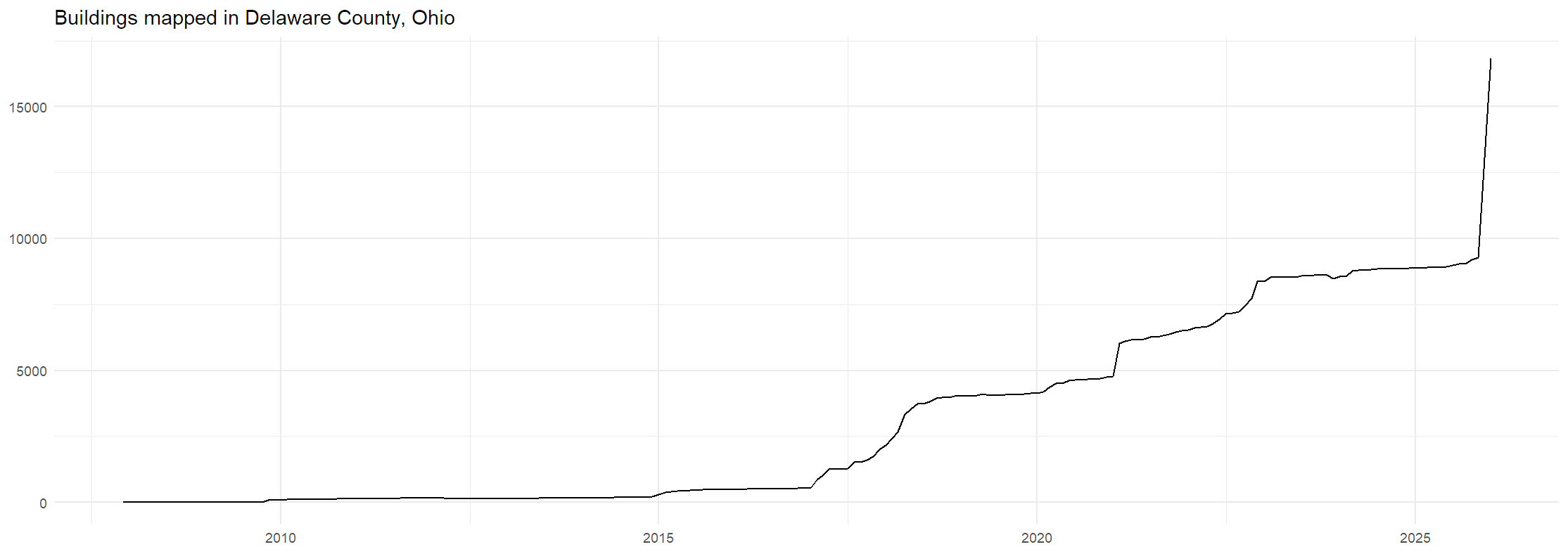
A chart of buildings mapped in Delaware County, Ohio. It spikes from around 9000 to 17000 at the end of 2025.

On November 4th, 2025, I noticed that there were 9,566 buildings mapped in Delaware County, and told a few friends that I wanted to push it up to 10,000. Since then, I’ve been mapping buildings in Delaware County daily, averaging over 100 buildings per day. Once I got it past 10,000, my next goal was to get it so that building mapping in 2025 would outpace building construction in the county. Delaware County is a rapidly growing county, so I did some napkin math and guessed that there were about 1500 buildings added to the county in the year. By the end of the year, I had easily surpassed that goal, and was now working to push back that date of keeping pace with construction further and further. You can see that in this graph:

… See full entry

Location: Berlin Township, Delaware County, Ohio, United States

OSM Oxford plans

Posted by Eiim on 2 August 2021 in English.

I’ve now been editing Oxford, Ohio for over a year, with more than 15,000 edits in the area and only a handful elsewhere. I figured it was finally time to set a proper goal for my editing: “complete” Oxford by the end of May 2022. For now, “complete” refers to mapping all the buildings, highways, POIs, and landuses, with perhaps some nuance. The details for each of these:

Buildings

By my count, there’s 7 neighborhoods/groups of houses left to map. That’s the most significant improvement from when I started a year or so ago, when we probably had around four or five neighborhoods mapped and only half of the downtown/uptown area. After those, there’s just a scattering of buildings on the outskirts of Oxford left. This phase of the project is nearing completion.

Highways

I have five goals for highways currently:

  • Consistent, accurate tagging of paths around campus

A number of paths are vehicle-accessible but aren’t labeled as such. I’m not sure what the proper tagging for those is, so figuring that out is the first step here.

  • TIGER cleanup

Easier said than done, or so I hear. tiger:reviewed=no is still on most roads in Oxford. I’ll need to do some research as to what TIGER tags should be kept or removed and such. I imagine the zip tags aren’t too useful.

  • Sidewalks

There’s lots of sidewalks around Oxford. I’ll probably map these separately, with crossings. That shouldn’t be too hard, but will take a good bit of time.

  • Intersections

I’m not sure about how much work there will be to do here, but I want to check up on things like the turn restrictions and traffic lights on all the intersections around Oxford. Some of this might be survey work.

  • Parking lots

There aren’t tons of these, but where they exist they’re very inconsistently mapped. Some work will need to be done to bring these up to standard.

POIs

… See full entry

Location: Oxford, Oxford Township, Butler County, Ohio, 45056, United States