CmdrThor's Comments
| Changeset | When | Comment |
|---|---|---|
| 63178074 | over 7 years ago | I've never heard of Ingress before, but mapping purposefully for their benefit would not be correct either. Since you've asked; I map purely for correctness and my primary use of OSM data is for offline navigation (Both in cars & while on hikes.) I do not map for the benefit of any particular application or service. ---- For the path that allows vehicle access I'm not sure which path you're referring to. I have been to this park in the past and I do not recall any of the paths allowing cars to drive on them. If a path is used by maintenance or service crews then adding motor_vehicle=private would be a better option as the intended use of the way is still a footway. ---- While footway or path would both work on and be valid for any of the paths in the park, if you read a bit further on the path wiki page: "This tag is used for paths for which all and any of highway=footway, highway=cycleway and highway=bridleway would be inappropriate or inadequate." Since the primary use of the paths in the park is as pedestrian paths highway=footway is the more appropriate tag. (Though, arguably bicycle=yes could be added to the ways as well.) If you do end up changing the footways to paths, I won't edit them back as like I said either tag would be valid, however footway is still the better tag to use. |
| 63178074 | over 7 years ago | Hey there, As I mentioned in my PM to you yesterday, please do not try to change OSM data to get Pokémon GO to behave in a certain way. There are many other users & consumers of OSM data and altering the map can break things for them.
For your future reference, service roadways are the lowest priority roadway in OSM, and cars are (generally) considered to be allowed on these ways. Highway=footway is correct for all footpaths within the park, and I have changed them back. If you haven't already, please have a look over the OSM beginner's guide: https://tinyurl.com/osmbeginners And the OSM best practices guide: https://tinyurl.com/osmgoodpractice And if you're not sure on what exactly a tag means, it's always a good idea to double check the wiki to see what values are valid or proper, or if there's perhaps a better tag that can go on the features. Also as I mentioned in my PM, please feel free to contact me for any question or concern you may have, I try to respond within a day and usually respond within a few hours. -Brandon |
| 62525448 | over 7 years ago | This changeset has been reverted by changeset/63149764. |
| 62525672 | over 7 years ago | This changeset has been reverted by changeset/63149764. |
| 62525759 | over 7 years ago | This changeset has been reverted by changeset/63149764. |
| 62526144 | over 7 years ago | This changeset has been reverted by changeset/63149764. |
| 63103456 | over 7 years ago | This changeset has been reverted by changeset/63149764. |
| 63103507 | over 7 years ago | This changeset has been reverted by changeset/63149764. |
| 63104339 | over 7 years ago | This changeset has been reverted by changeset/63149764. |
| 63104383 | over 7 years ago | This changeset has been reverted by changeset [63149764](changeset/63149764). |
| 63149764 | over 7 years ago | User had deleted data attempting to get better raids on Poke Go. User has been notified of changeset reversal. |
| 62858583 | over 7 years ago | All appears correct from my end as well. And no problem, always happy to help local mappers. Feel free to hit me up if you need any help in the future. ~Brandon |
| 62858583 | over 7 years ago | Yeah, it's gone. JOSM just wasn't showing it as gone for me when I was updating the layer. I already fixed this for you (I didn't notice it until I was digging deeper in to the relations as I was going to remove that 'leftover' restriction at the same time), but make sure 'from' way is always position 1, the 'via' is always position 2, and the 'to' way is always position 3. To most routers the order of the members /shouldn't/ matter, but the turn restrictions plugin may throw an error if it's not in the expected order. |
| 62858583 | over 7 years ago | (Sorry to keep commenting, my thoughts flow randomly) One small change I would make is to place the traffic_signals on the incoming ways, instead of at the junctions themselves. Basically make it so if you were 'driving' down each way, no matter which way you turn you'd only pass though one set of lights. This is more done for the routers to help with time estimations. |
| 62858583 | over 7 years ago | I just looked over your restrictions on the intersections, they look correct to me. I do see one leftover restriction at Phoenix & Winghaven (Relation #8729810) that should be removed. ~Brandon |
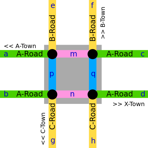
| 62858583 | over 7 years ago | The ways probably need to be split if you're getting errors. Either that, or as I said the plugin can't automatically handle using ways as via's, it must be done manually in the advanced tab. (Or you can always make the entire relation by hand bypassing the plugin all together.) Also, I feel like maybe I didn't explain the "ways as via's" thing completely, so see this example image: osm.wiki/w/images/thumb/6/6f/Doublejunction.svg/480px-Doublejunction.svg.png To prevent u-turns on 'A Road', you'd actually be creating a restriction from 'n' via 'q' to 'm'. (And likewise from 'm' via p' to 'n') C Road would be from 'q' via 'm' to 'p', and B Road would be from 'p' via 'n' to 'q'. Hopefully that makes a bit of sense. |
| 62858583 | over 7 years ago | Actually, upon further review it looks like you brought each dual-carriageway down to a single (short)way to add no u-turn restrictions. To properly map the no u-turns on a dual-carriageway, you can set your from and to ways as normal, but set your via as the short bit of way between the two sections. If you're using the "Turn Restrictions" plugin for JOSM I don't believe the plugin can automatically add the via, you have to go to the advanced tab and drag the selected way in to the 'raw members' area and specify that it's the via way. I just added u-turn restrictions at Winghaven & Technology Dr so you can see an example of how to map these in the future. ~Brandon |
| 62858583 | over 7 years ago | Hey there, It looks like you've combined all the incoming ways to an intersection to a single junction, this is not the correct way to map intersections. Ideally, you want to have all ways intersect each-other, and then place the traffic control nodes on each incoming way. See the nearby intersection of Winghaven & Technology Dr as an example of a correctly mapped intersection of two dual-carriageways. Each of the 4 ways intersects each-other, and the highway=traffic_signals is placed on each way before the junction. Also see the wiki articles on Junctions: osm.wiki/Junctions and on traffic_signals: highway=traffic_signals for the best methods of mapping these features. Let me know if you need any assistance with this, or have any further questions. ~Brandon |
| 55954351 | almost 8 years ago | Wrong link.
|
| 54835012 | about 8 years ago | (Ran out of room on the changeset description)
|