OpenStreetMap

vvoovv's Diary

Recent diary entries

Alt text

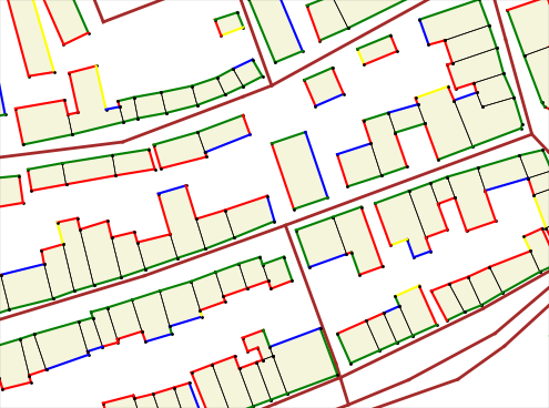
We implemented the visualization of the facade visibility from neighbor streets within the Blender-OSM project. Green color on the image: facade is totally visible, red: facade is invisible, black: shared building wall. The other colors are used for in-between visibility states.

Blender-OSM is an open-source addon for Blender that creates city environments out of OpenStreetMap data. The addon source code is hosted on Github: the development version, the release version. To fund the addon development a version with assets is sold at https://gumroad.com/l/blosm

The visualization of the facade visibility from the neighbor streets is possible without even installing Blender.

Installation

  • Download the addon code base from here
  • Unpack it
  • Rename the top folder from blosm-facade_visibility_demo to blosm
  • Install some common Python packages:
    • pip install scipy
    • pip install mathutils
    • pip install matplotlib

Usage

To visualize facade visibility for a local OpenStreetMap file:

cd /path/to/blosm
python -m script.command_line --buildings --highways --setupScript setup/mpl_facade_visibility.py --osmFilepath /path/to/your/file.osm

To visualize facade visibility for OpenStreetMap data from the server:

cd /path/to/blosm
python -m script.command_line --buildings --highways --setupScript setup/mpl_facade_visibility.py --osmDir /path/to/folder/for/downloaded/osm/data --coords 13.42697,52.51586,13.44132,52.52046

Replace coordinates after the –coords flag with coordinates of your area. The format of the coordinates is min_longitude,min_latitude,max_longitude,max_latitude

2.5D maps with Blender and Tilemill

Posted by vvoovv on 2 June 2014 in English.

2.5D maps are ordinary 2D maps enhanced with a layer of 3D buildings rendered in the oblique projection.

2.5D maps

Two open source tools are used to generate 2.5D maps: Blender and Tilemill.

Detailed instruction is here.

I’ll give a talk at SOTM-EU 2014 about 2.5D maps on Friday, June, 13 at 16.30

Blender is a 3D platform. It supports 3D modeling and rendering as well as many advanced features like animation, simulation, compositing, motion tracking, video editing and game creation. Here I describe my way way to learn Blender.

Blender is used to model buildings, georeference them and render in the oblique projection.

Tilemill is open source tool to create stunning interactive web maps. Tilemill is used to generate a 2D map and combine it with the layer of 3D buildings rendered in the oblique projection by Blender.

Only 2 days left for the Early Bird registration of the conference SotM Baltics 2013.

Take the last chance to take part in the first Baltic OpenStreetMap conference for just 11 Euro: http://sotm-baltics.org/register.html

Payment can be made through a number of ways: - credit card - PayPal - bank transfer - cash at the conference

So far we’ve got a significant number of participants from Estonia and Russia. Mappers from Latvia, Finland, Germany, Netherlands and Afghanistan are also registered for the conference.

There were complaints that it wouldn’t be easy and cheap to get to Tartu and back. Believe me it’s not true. I can help you to plan your trip. Just send me a note.

State of the Map Baltics conference will be held this year on the 3-4 of August in Tartu, Estonia. For the first time ever mappers, developers and users of OpenStreetMap from Baltic States, Russia, Finland and Sweden will come together to exchange knowledge, strenghten local communities and break the language barrier. Mappers from other countries are also welcomed!

We’ve managed to get a wonderful venue for the SOTM Baltics!

The conference will be held in the main building of the University of Tartu: http://sotm-baltics.org/location.html

The conference hall is normally used for PhD defence and University Senate meetings. The University of Tartu was found in 1632, its main building was built more than 200 years ago.

Register before the 9th of June for just 10 Euro: http://sotm-baltics.org/register.html

The Call for Papers will be announced in a few days.

State of the Map Baltics conference will be held this year on the 3-4 of August in Tartu, Estonia. For the first time ever mappers, developers and users of OpenStreetMap from Baltic States, Russia, Finland and Sweden will come together to exchange knowledge, strenghten local communities and break the language barrier. Mappers from other countries are also welcomed!

Good news for those missing SOTM in Birmingham or living close to Baltic Sea.

For the first time ever mappers, developers and users of OpenStreetMap from Baltic States, Russia and Finland will come together to exchange knowledge, strenghten local communities and break the language barrier. Mappers from other countries are also we

State of the Map Baltics conference will be held this year on the 3-4 of August in Tartu, Estonia.

Early Bird Registration for the SOTM Baltics is open: http://sotm-baltics.org

Register before the 9th of June for just 10 Euro!

Google Sketchup as OSM editor

Posted by vvoovv on 14 February 2011 in English.

The first building tagged source = sketchup2osm is already in the OSM database:
http://www.openstreetmap.org/browse/way/99697450/history

I'll release the source code by the 23th of February. I need to clean up the source code and write documentation.

It will be possible to map buildings using 1-2 ordinary photos via Photo Matching feature of Google Sketchup.

Main features:
- Import of an OSM file to Google Sketchup
- Import of a gps-track in NMEA format to Google Sketchup (support of GPX format comes a bit later)
- Export from Google Sketchup to an OSM-file

Screenshots:
http://img831.imageshack.us/i/osm2gsu.jpg/
http://img826.imageshack.us/i/osmgsu.jpg/

Photogrammetry: update

Posted by vvoovv on 10 March 2010 in English.

In order to simplify installation and further development we have rewritten Bundler's script in Python. Details about their installation and running as well as best practices to take photos for Bundler input can be found at the OSM-wiki:
http://wiki.openstreetmap.org/wiki/Photogrammetry

Absolute orientation is unknown for 3D scene reconstructed by osm-bundler. So the problem is how to estimate the up-direction for the reconstructed scene.

One option would be to take into account the observation that "most photos are taken without significant twist (rotation about the camera’s viewing direction), and compute the up vector which minimizes the amount of residual
twist over all cameras." This method is used by the author of Bundler.

Also one can notice that most of buildings have vertical and horizontal edges. One could try to estimate a dominated direction that the reconstructed 3D points form.

If you have other ideas how to calculate up-direction please post them in the OSM-forum: http://forum.openstreetmap.org/viewtopic.php?id=6703