OpenStreetMap logo OpenStreetMap

PlaneMad's Diary

Recent diary entries

Finding the local experts

Posted by PlaneMad on 6 December 2016 in English.

Planning a trip to a remote area and realized it would be really cool to meet other mappers in the region where i’m traveling. Wish there was an easy way to broadcast a message to the top/recent contributors in a location. Right now the easiest way seems to be looking at the the list of top users when editing in iD and sending them message.

Any other tools that could help? Very few users are on any community communication channels here in India.

The Fukuoka sinkhole is mapped

Posted by PlaneMad on 9 November 2016 in English.

You’ve probably already seen the video of the Fukuoka sinkhole swallowing up large parts of an intersection. This obviously necessitates a map update, as it could be a little bit of an inconvenience to drive on this stretch.

In Japan updates are quick, both on the map and in the real world. From the detailed traffic restoration plan the road might actually be back to normal before any other map gets updated ;)

Location: Reisenmachi, Hakata Ward, Fukuoka, Fukuoka Prefecture, 812-0025, Japan

Scaling multilingual name tags with Wikidata

Posted by PlaneMad on 8 November 2016 in English. Last updated on 9 November 2016.

Wikidata, the crowdsourced database of structured knowledge by the Wikimedia movement has grown to over 24 million entries and by now has structured information for every major settlement on earth. These are extremely useful properties like multlingual labels, statistics like populations and GDP, and other related information like politics, history and media about the place (See London, New York City, Timbuktu).

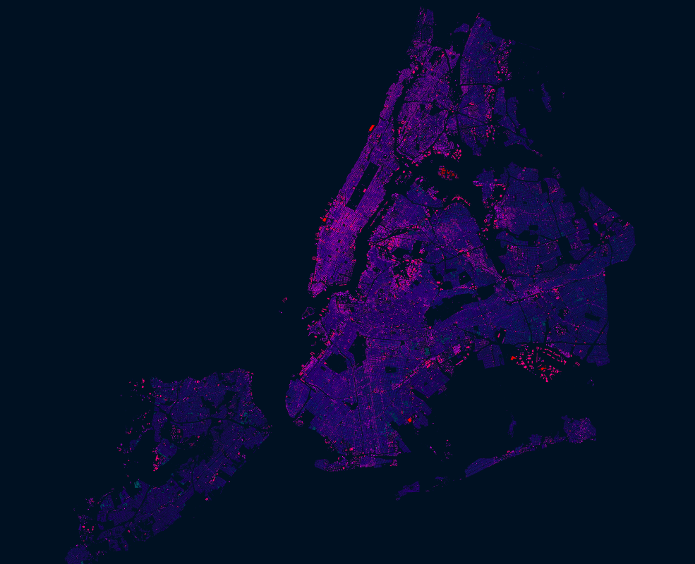
Geolocated articles on Wikidata, with those added in the last year highlighted in pink. Source: Wikidata Map

Current state of multilingual tags

See full entry

How many POIs does OpenStreetMap have?

Posted by PlaneMad on 1 October 2016 in English. Last updated on 11 May 2017.

Might depend on what exactly one considers a point of interest, but looking at some common keys:

we get around 20 million features that could be potential landmarks or points of interest.

Just counting points that have names, we get around 12.9 million features.

Addresses

70 million individual addresses and 49 million postcode locations

Maybe there is a better way of finding out, but here’s a new conversation starter at your next mapping party!

Found myself at the Royal Observatory this morning (on the map), and discovered a bit of trivia since I expected to be located at longitude: 0°0 as my geography class would have made me believe. Well, its not:

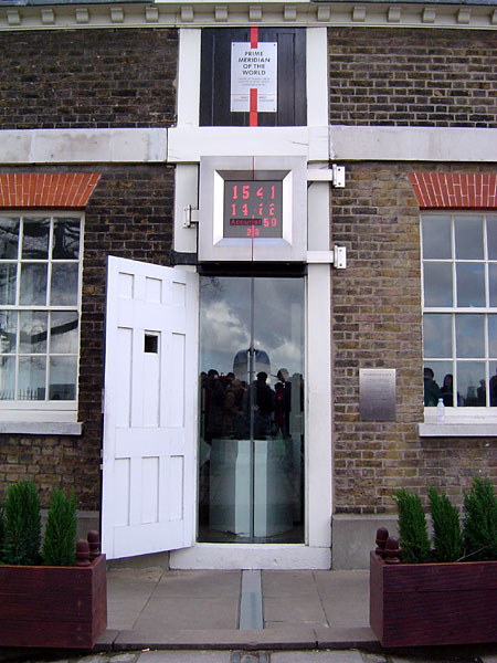
Prime meridian at Greenwich. CC-by-sa ChrisO

The prime meridian established at the Royal Observatory, Greenwich in 1851 is actually at 0°0′5.3″W, thats 102m west of the the 0°0 prime meridian used in the WGS 84 coordinate system. Why? Because the modern coordinate system was corrected to have its origin at the Earth’s centre of mass.

Read more at https://en.wikipedia.org/wiki/Prime_meridian#International_prime_meridian

See full entry

Location: Greenwich Town Centre, Royal Borough of Greenwich, London, Greater London, England, SE10 9GG, United Kingdom

There is an open dataset of turn restrictions in Toronto which gives a rare opportunity to completely map every restriction in the city.


Inspecting the dataset in QGIS

The dataset consists of the topology of road centerline of every junction in the city, and at every junction, each possible turn direction is an individual line with a property that indicates the type of restriction on it.

Most of the restrictions are u-turns and no turns into one ways. The only restrictions which look valuable to add into OSM seem to be the no turns (By law) which number about 520.

See full entry

Splitting intersecting features

Posted by PlaneMad on 30 June 2016 in English.

While tracing an area of continuous buildings in India, realized there was no easy way to create such a pattern of features in JOSM.

How does one split a group of ways using an intersecting line. The More Tools>Split Object command comes closes but works only with a single way and line that it encloses and is quite laborious.

untitled2

Terracer plugin does not work well since the area is not a perfect rectangle, so it does not get the axis right. Any other editor/plugin capable of drawing this quickly?

Location: LBS Nagar, Halasuru, Bengaluru, Bangalore North, Bengaluru Urban, Karnataka, 560008, India

The problem

A new user accidently added addr:city and addr:province tags to a large selection of objects, including rivers and individual nodes.

screenshot 2016-06-24 13 58 54
Changeset | Diff

The user mentioned that the tags were intended only for buildings, so thought I would document the cleanup for future efforts like this.

Finding all the problematic data using Overpass

It is possible to extract all objects with addr:city added by the particular user using this Overpass query.

See full entry

Location: Kaunlaran 2 Village, Molino, Bacoor, Cavite, Calabarzon, 4102, Philippines

The invalid areas of the map

Posted by PlaneMad on 21 June 2016 in English. Last updated on 22 June 2016.

There is some interesting research on the validity of polygons/area features mapped on OSM by Jochen Topf the creator of the osmium suite of OSM processing tools. There seems to be two major problems:

  • There exists multipolygons in OSM that have the old style tagging, with the tags on the outer way, rather than the relation
  • Polygons or multipolygons with a gemotry that is invalid, the most problematic being an unclosed area

In his usual style, there exists an in-depth explanation of the problem. Bonus is a chapter on OSM polygons and how they are rendered for GIS nerds.

Of the over 220 million (multi)polygons in OSM more than 100,000 contain mapping errors of one kind or another and about 250,000 are tagged old style with tags on the outer ways instead of on the relation making multipolygon tagging and processing much more complicated and much more expensive than it needs to be. Read more

I dug into the dump of invalid polygons and inspected it in QGIS to get an idea of the breakup of issues to see if they can be prioritized to fix:

By node count of area

See full entry

A rather inspiring story came to my notice last week on World Environment day from Chethan during lunch, that of a lady who mothered thousands of trees just like her own children in rural India, not too far away from here in Bengaluru.

Wikimedia

Saalumarada Thimmakka has planted over 8,000 trees, the most famous being 384 banyan trees on a 4km stretch of road from her home village Hulikal to Kudoor.

A bunch of us mappers Chethan, Maanya and Ramya plan to take a ride out of the city to meet this amazing lady and plant her banyan trees on the map!

Location: Hulikal, Magadi taluku, Ramanagara, Karnataka, 561101, India

Is that a country?

Posted by PlaneMad on 3 June 2016 in English.

Found this oddity through Chetan, that I never recalled seeing before.

At first thought someone squared a border, but this was created 4 years ago and is a disputed border area between Chile and Argentina.

Not been able to find many maps that show the border like this, but here is some interesting reading:

See full entry

Location: Natales, Huertos Endesa, Puerto Natales, Provincia de Última Esperanza, Magallanes and Chilean Antarctica Region, Chile
NYC had an import of over 1 million building footprints and 900,000 addresses in 2014 from the New York City Department of Information Technology and Telecommunications (DoITT). The DoITT GIS releases an updated shapefile of the footprints every quarter, and the latest version can be accessed here: Building footprints Address points

Open datasets like these are a great opportunity to explore how OSM can be used as a bridge between authoritative information and that crowdsourced by citizens. Two years after the import, it is interesting to see how the OSM data compares with the latest official footprints. The interesting questions to ask is:

  • What has improved in the DoITT footprints that can be updated in OSM?
  • What has improved in OSM that can be updated in the DoITT data?

See full entry

Iquitos is a city of 370,000 in the middle of Amazon jungles of Peru without a road connection with the outside world. Found it while investigating routing failures in OSRM.


Here’s a great travelogue of this fascinating place while trying to research possible car ferry connections. There are none.

Maps lead you to interesting places :)

Location: Isla Iquitos, Belén, Province of Maynas, Loreto, 16001, Peru

Validating the map - Part 1

Posted by PlaneMad on 6 April 2016 in English. Last updated on 7 April 2016.


Hello Kitty

Quality assurance in OSM is a pretty hot topic. The first question when first faced with the concept of a map that anyone can edit is - how can one guarantee the quality of the data?

In a constantly transforming world, the fact is that its impossible to gaurantee any map in the world is accurate unless it was physically surveyed recently. And the reason why OpenStreetMap has such high quality of map data for many parts of the world is precisely because this project allows anyone to update the map so easily. And to ensure quality, we just need more users of the map for that location, an empower them to update anything that does not match reality.

Recent incidents

For this to work effectively its obvious we need to make it as simple as possible for map users to spot mistakes and make an update. Some interesting data incidents that were caught by the community recently:

See full entry

Making a multilingual map of India using OpenStreetMap data

Posted by PlaneMad on 18 March 2016 in English. Last updated on 18 September 2016.

untitled2

One of the main reasons I was convinced of the power of OSM when I first started to edit 8 years ago was the possiblity of seeing maps in my native language Tamil, spoken by 70 million people, which was till then unheard of. This is a huge factor in making technology relevant for people on the ground and breaking the notion that one needs to be literate in English or the Latin alphabet to be able to use modern tools like interactive maps.

There have been numerous experiments at making multlingual maps in India, I remember Yahoo maps having Indic streetmaps for India in 2007, but was soon discontinued. Google Maps for India is primarily in English and even in OSM we use the name tag to record the name in the Latin alphabet for consistency. India has 22 languages, none of them universally understood by the whole country. Even the national survey agency makes only English maps, with a select few created in Hindi.

See full entry

Location: Indiranagar 1st Stage, Bengaluru, Bangalore North, Bengaluru Urban, Karnataka, 560038, India