
We’ve got a London pub meet-up TONIGHT at the Penderel’s Oak.
Our last London meet-up was an interesting one. Matt suggested meeting at a pub in Angel. Not an area we’ve been to in a while because it’s in the Blumpsy mapping zone of awesomeness. But it’s also nicely near my journey home, so I wasn’t going to complain.
The Mucky Pup pub is in a residential area I’ve never explored before, so although it’s quite close to my office, I decided I needed a route map printout. And for that there’s this awesome new site cycle.travel by Richard Fairhurst. Awesome particularly because after planning a route on the site you can download a PDF, and not just any PDF. A vector PDF! This is exciting. Ever since I started OpenStreetMap I’ve had a feeling that there’s massive untapped potential for using it to create high quality map printouts. There’s various tools (see ‘OSM on Paper’). cycle.travel is a nice addition to those.
It’s designed only for printing cycle routes, not for general purpose printing, but on this occasion a cycle route is what I needed! Before I sent to print I fiddled around for rather too long to scale up the map to A4 size (I thought I could do this in the printer settings, but eventually found it was surprisingly easy to ‘crop’ using ‘preview’ on a mac). The result… awesome printout!
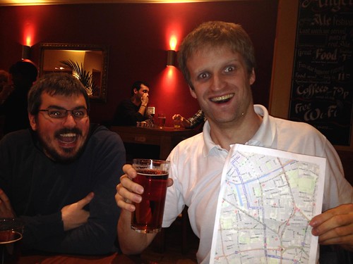
but… and I knew this would happen… Andy, Matt, and others also had great fun scrutinising the printout to find all the Mapnik glitches and make various other cartographic criticisms.
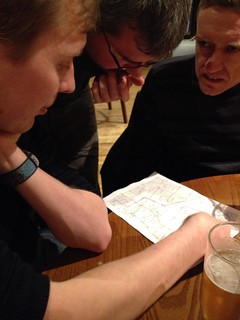
With a vector PDF the glitches are laid bare a little more than web maps we’re used to (Some would normally be lost in sub-pixel fluff) especially as I had scaled it up to fill the whole A4 sheet. Certainly cycle.travel printout made for some fun pub conversations.
We talked a bit about vector manipulation in inkscape, and how Mapnik generated text is a bit of a pain.
We talked about border disputes. These crop up sometimes in OSM, but we were actually talking about real world disputes, and how technically even the UK has disputed borders. Technically we shouldn’t qualify to be part of the EU, because there’s a lock gate somewhere in Ireland where it wasn’t decided who owns it. I’m glad I live in a time and place where such things are just a curiosity.
We talked a lot about promoting OpenStreetMap to developers, starting from the thing which winds me up a bit, that if you go to a hackathon in London (There’s one every day of the week if you look out for them) or any other event where fresh young talented developers go along to strut their stuff… It’s still not regarded as uncool to use google maps. We need to get to that point, because really it is uncool from a philosophical point of view. I want developers to feel ashamed of themselves to be presenting a hack on google maps, in the same way that it’s shamefully uncool to be doing anything using internet explorer (or windows for that matter)
Things are moving in that direction, but we have a way to go to make things easy enough for rapid hit & run hackathon developers. We talked about where the “hackathon problem” sits on a developer long tail curve. There’s a very large number of people who’ve figured out how to build websites with map on a “contact” page for a business site. Trivial to swap in OpenStreetMap, but that needs to be dead easy, and even then they’re unlikely to bother. At the other end of the scale we could try to make things easier for developers who want to install their own tile server, shunt OSM data around with diff-syncing, and do custom cartography. It’s a tiny minority of developers who will ever get that advanced. “hackathon” developers are somewhere in between. Things need to be dead easy for them, because even though they’re smart enough to throw a bit of data around, they have frustratingly short attention span when it comes to learning something which isn’t google maps. They’re somewhere half way up the long-tail curve, but it’s worth trying win developers over at every point on this curve because elite power-developers are “thought leaders” who will show the way for others, right down to the people who make the little “contact” pages all over the web.
That was the last London pub meet-up. More photos here. Since then I’ve been up to a few other OpenStreetMappy things.
At the weekend I actually put on my OpenStreetMap Polo shirt and went to our favourite pub, the Monkey Puzzle, without any of the usual OSMLondon guys. Felt very strange. I did this to meet with Mike Newton who is going to be helping us make a tutorial video series, including some edited documentary-style footage. Interviews with people and locations of significance (such as the monkey puzzle!) for OpenStreetMap. I think it could be awesome, but we’ll see how it goes. Also we made some plans to put a general call out for some video clips to include in this, preferably from OSM enthusiasts around the world. So an opportunity for everyone to help with this. More details on that coming soon.
We’ve just had the Humanitarian OpenStreetMap Team board elections. HOT members have re-elected me onto the board for another year. I don’t feel like celebrating just yet. It’s difficult to express what a hard week of politics and sleepless nights I’ve just had. Clearly I’m not cut out for politics! …Maybe I just need a beer.
TONIGHT there will be beers. This is a little pub event we’ve sneaked in before the big hack weekend this coming weekend (including pub this Friday). That’s going to be massive. Tonight’s pub is looking like it might be a fairly small gathering. I’ll be calling in late after my Portuguese class, and I won’t be hanging around too long. I have a wedding to plan. In fact I will probably need to be skipping a few of these upcoming events (gasp!). I’ve scheduled the next few events on the page there and it’ll be up to some other people to organise it.
Discussion
Comment from pnorman on 5 March 2014 at 11:05
When I did work on print rendering I found mapnik PDF rendering was worse than AGG rendering for text. I’m not sure if this has improved with recent versions, but I ended up doing 600 DPI PNGs and embedding them in a PDF.
Comment from Tom Chance on 5 March 2014 at 11:29
On hackathons, is this not just about moving from Google maps to OpenStreetMap, but from Google maps to leaflet or openlayers, from Google maps engine to geojson.io, and so on?
We lack the tool chains associated with Google Maps, like the ability to quickly knock up a map of pins in an easy UI, or something more advanced using Google Maps Engine, and other products past and present like Google Refine. These are particularly relevant to open data hacks, because it’s much much easier to use the Google tool chain that to try and stitch together different open source products if you want to clean up, analyse and visualise open data on maps.
The alternatives are popping up and improving all the time.
Maybe we could also have an equivalent to “best of OSM”, showing off “best hacks using OSM and associated open source tools”?
Comment from aseerel4c26 on 5 March 2014 at 20:53
Am I misusing the site or is http://cycle.travel/map England-only? :-( I dislike this: you click a link, navigate through a site… only to find out that it is not servicing your location. This should be mentioned in this blog post and in OSM_on_Paper if it is that way. Thank you, Harry!
Comment from aseerel4c26 on 5 March 2014 at 20:55
… and it needs a sign-on/log-in to get the wonderful pdf :-(
Comment from Harry Wood on 6 March 2014 at 09:46
Yeah you’re probably right. Haven’t tried, but I presume it’s UK only from what you say. I’ve added a note on the wiki listing.
Comment from Harry Wood on 6 March 2014 at 09:56
@Tom Chance. Yeah you’re right. Lots of nice features of google maps tools. We’ve got most of it, but developers have to go hunting for the features across many open source tools. There’s a thing I’ve noticed google fusion tables does, to avoid the problem of too many markers overloading the browser, it actually render markers onto raster tiles if there’s too many of them. Seemlessly switching from pure javascript to some server-side work (I assume). It’s really neat the way this happens without the developer needing to be aware of it. Some joined-up thinking like this in OSM toolsets would be a good thing for the hackathon level of developer.
Comment from aseerel4c26 on 6 March 2014 at 13:24
In fact it is only Great Britain (no Northern Ireland). Have added it.
Comment from malenki on 9 March 2014 at 21:12
Regarding “Make it dead easy to use OSM in Websites”:
To people who mainly want to link their business on/with a map I recommend http://www.openlinkmap.org/.
When the business mapped contains a phone number, opening hours or a website it shows up on that map (iirc).
Now they just have to click their business, click [HTML-Code] and copy the latter (from the box at the left side) to their website.