
iOS, geomob and pub tonight
Posted by Harry Wood on 25 September 2012 in English. Last updated on 28 September 2012.As I get psyched up ready for a London mapping session this evening (Listening to “Eye of the tiger”. That sort of thing) I realise it’s been an interesting few weeks…
Last week I went to Amsterdam and presented OpenStreetMap and H.O.T. at the PICNIC festival. Here’s a video of the session. There’s another interview video still to come I think. I’ll blog some photos and more details about that. UPDATE: blog now here
Last Thursday I had been sprinkling a few comments around the web, on press coverage of Apples debut of their iOS6 maps. iPhone users the world over, were loudly complaining about apple’s switch from google maps. This really shows how strong the big G’s dominance of web & mobile mapping is. Phone users and also tech-savvy app developers are insistant upon google maps. It’s hardwired deep into their psychology now, such that forcibly presenting a different map causes great upset. This is what OpenStreetMap is up against, but last week apple swung a battering ram at google’s mappy castle. They may be annoyed but users and developers being liberated. They’re experiencing a realisation that there is a choice of map providers. It’s only a short leap of logic from there to go seek the open alternative. That’s us! Over here!
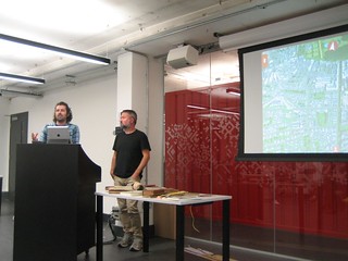
So after spending the whole day pointing out what an evil grip google holds on people’s map preferences (slagging off google essentially) on various forums, I half expected to be refused entry the google campus building for Thursdays #geomob. Maybe I thwarted them by turning up late. I caught the end of Lawrence’s talk showing various old maps, and concepts for maps, particularly looking at “linear maps”. Anyone done any more OSM experiments on Linear Maps to list on this wiki page?
Then “recce” guys presented their map. It’s stunning, but be warned, it’s not OpenStreetMap (boo). Actually if you want an OpenStreetMap-based similar thing, UK travel options has a similar 3D zoomy twisty finger swiping experience (and UK wide), but admittedly not as gorgeous as Recce’s semi-realistic cartoony look.
In the pub afterwards I had a good chat with Bart Denny of recce, formally of google maps. He said he liked the idea of OpenStreetMap, but what’s a good mobile app for contributing easily? I had no convincing answer to this question, and he was quite forthright in his criticism of OpenStreetMap for failing to get this sorted out. Now admittedly I’m not an expert on all the apps available (who is?) but I had to agree with him, that we really badly need better mobile apps for contributing to OSM.
He had a theory (which he also stated in relation to Recce, and his previous work at google) that map data gathering is about to become very smartphone-based and that the problem of building a complete and accurate representation of the world will largely disappear. Phones are already powerful enough and widespread enough that map providers could get their users to capture data with a simple panoramic sweep of their camera (and some very clever optical recognition) Who owns that data is still a question. If OpenStreetMap can stay in the game it can eventually win out by offering it as open data. But we have a little way to go before that!
We have an opportunity to grab some attention of iPhone users who are looking around for better map apps, but it’s an opportunity we’re missing a little bit because our list of iOS apps is a bit confusing. We’re listing some quite old apps, some which don’t work any more, some which have nothing to do with OpenStreetMap except that they can be used for recording tracks. It’s quite difficult to find the gems in there. Those doing interesting things with offline data or vector data (the OpenStreetMap advantage) or those with editing capabilities. A lot of the wiki pages need a bit of a rewrite, sometimes with obvious formatting / info from the appstore (see Wiki Maintainance Tasks ), ideally by actually installing the app to test what it actually does. Who wants to help?
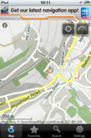
I started doing this and happened upon DirectU (now with some wiki description). It’s a free app which gives me the whole of Europe (or other regions) for offline viewing. Rather like MapDroyd but working on ipod touch. Nice!
We’re also not doing too well at documenting and promoting the “upgrade path” for iOS developers to use various libraries for embedding OpenStreetMap. There’s a list of options here, but maybe we need to compose some new pages for switch2osm.org on this topic. Lots to do!
But for now… I need to go to the pub! No doubt we’ll chat about some of these issues while eating the nice steak pie they do at the Monkey Puzzle. If you’re in London, come join us (TONIGHT!)
Discussion
Comment from Bartdenny on 26 September 2012 at 12:02
Thanks Harry for sharing my theory - it’s one of those things that once you think about, it is pretty obvious. We are currently carrying around supercomputers packed full of sensors in our pockets; only a matter of time before this swarm of 1 billion devices can capture the raw data, and OSM contributors can then refine into a map that approximates absolute ground truth.
As for how OSM can begin, I think simple error reporting via photo upload could be very powerful - snapping a picture, categorizing the type of problem and upload. Then contributors can take a look at the photo directly on the map where the error was reported, and potentially there is enough info there to update (add a street name, refine the intersection, etc.
One only need to look at the massive improvement of maps that Waze has seen to recognize the viability of the smartphone-centric approach.
(and as for why Recce app does not use OSM - we need 3D building data, so was not a real solution for us. But hopefully someday OSM contributors can create that data with their phone!).
Comment from Harry Wood on 26 September 2012 at 13:15
Error reporting via photo upload we don’t have yet. That’s a good idea. We have a system called OpenStreetBugs for text based bug reporting. This website probably works ok on a mobile. There’s an API too. Not sure if that has been integrated into any native mobile apps, but it wouldn’t surprise me if Navit and OSMAnd have it (not sure). But a dedicated app for just this, might be good. And photo support as you say. There’s actually two categories of bugs. Things which somebody is reporting, as data from the real world, to be added, and things where the data/map looks wrong and we need a survey in the real world to resolve it. So a photo might be part of creating a new bug, or solving a bug in fact. We can think of it as sending a local person on a mission to get a photo of something specific. OpenStreetBugs is set to be incorporated onto the main OpenStreetMap.org front page, so that will bring these ideas to the fore I think.