
I’ve just arrived in Washinton D.C. now, but that’s another story. I’ve been away in Brazil having a nice holiday, but not really a holiday from OpenStreetMap. no no no. Lots of mapping. And even some OpenStreetMap meet-ups!
While packing in a bit of a hurry I managed to forget my GPS unit. My poor old NaviGPS has been languishing unused for so long, I’m not even sure where it is any more. But I did have my android phone for mapping, and I recently learned…
- When the android GPS icon is flashing, it doesn’t have a location. It doesn’t flash each time it’s sampling or anything like that. When it’s flashing it has no GPS lock yet. My phone can take a good couple of minutes to get a GPS lock and stop flashing
- When the GPS icon stops flashing and is on permanently, it works quite well, and stays on assuming (I guess) you’re running an app which asks for the location often</li>
- The Power widget lets you toggle GPS to switch it on, but this more like ‘enabling’ it. It won’t even begin getting a lock until an app first asks for a location.
- This means for example when I first select “My Location” in MapDroyd it has no hope of telling me my location!
In fact I’m sure those things should’ve been obvious, but I guess I just didn’t bother paying attention until recently. My phone (a cheap £100 Orange San Francisco AKA ZTE Blade) is a bit slow, which irritates me to the point of not bothering quite a lot of the time. Maybe this influenced my choice of tracking apps. oruxmaps has worked for me in the past (the recommendation here ), but I used OSMTracker throughout this holiday. Seems quite nice and simple. In fact the features could be stripped down further for my purposes. I just used it for recording a track, while doing photo mapping using my seperate camera.
The other thing I tried out was downloading maps into Mapdroyd using the ‘Via PC’ button. It works, unlike direct downloads into the app which have become very unreliable lately. I dont know if this is due to problems at the CloudMade server end. ‘Via PC’ works but is a bit convoluted It’s a shame the reliability/ease of the download is holding back this awesome app from taking OSM to lots of mainstream users. Anyway mapdroyd gave me an OSM map of Brazil for the holiday, and it seems to be pretty up-to-date.
This included recently sketched in unnamed roads for pretty much the whole of Guarulhos , where my girlfriend’s family lives. I’ve done some mapping in Guarulhos on previous trips, but I recently got into an amusing conversation with a foursquare superuser (somebody who spends their life contributing to foursquare and takes it very seriously) who was criticising OpenStreetMap and complaining that the Guaruhlos map was rubbish. At that time is was pretty rubbish. The map had maybe a quarter of the city’s roads sketched in from bing, and just handful of those with names which I’d gathered. User:Toi spotted this discussion and responded proactively with a mammoth armchair mapping sprint to map the whole of Guaruhlos. Nice! Just need to work on the road names now. I got chance to bag lots more road names while out there. Still need to enter them in.
I also mapped as we went along on a week long trip to Paraty and visiting many surrounding beaches on the beautiful mountian jungle coastline just north of São Paulo. I like the native indian places names: Ubatuba and Caraguatatuba. There’s a geo-attraction in Ubatuba: A marker thing for the line of the tropic of capricorn. There’s also this shop helpfully providing it’s latitude and longitude! I mapped things like this, plus general city mapping helped by bing in Ubatuba, but no bing for Paraty (Brazil has funny stripes of bing coverage ) Some stuff was on the map already. The most striking omission was…
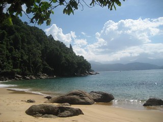
Beaches! (“Praias” in portguese) The towns and suburbs on the coast are all characterized by their beaches, and often named after them “Praia xxxx”, so for anyone other than a passing motorist, a meaningful map of the area needs natural=beach areas drawn in, It’s an easyish armchair mapping challenge, particuarly where bing is available, and it made me wonder why nobody had done it yet in this area, and also could it be a fun topic of a coordinated sprint, like the big baseball project? I say easy-ish because it’s not quite as easy as a baseball pitch. Although beaches are easy to spot, even in landsat imagery, you have to attach them to the coastline way in a slightly fiddly manner, and the slower coastline rendering update cycle can create confusion. The coastline way itself needed refining in this area, and that of course is a massive wordwide and fractally endless armchair mapping task, but this area still had a lot of coarse PGS coastline despite bing coverage.
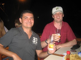
And then there was the São Paulo meet-ups! I’ve managed to do a little OSM meet-up on the past three times I’ve been there. They laughed about how they don’t actually organise meet-ups and don’t see eachother except when I’m in the country. This time we bounced emails around in circles to try to pick a good time, but seemed to fail. Just me and Claudomiro made it to the actual OSM meet-up, but with numbers boosted by some other friends who (of course) we tried to persuade to become OSMers.
But then I spotted that the Open Knowledge Foundation were running an event the day before I was leaving. Pizzas, cervejas, and dados abertas!. I think this was a big coincidence. I’ve been to a couple of OKFN events in London, and the main man Rufus Pollock happened to be in São Paulo at this time, where OKFN are setting up a brazilian branch. They’d also been on tour, attending an open data government conference in Brasilia. This is the same conference I noticed Mapbox guys tweeting from and doing mapping at. But at this event we sat around on beanbags discussing open data, with beers and pizzas, in a funky place called ‘Casa da cultura digitale’, which is also host to the São Paulo hackspace

And the OSMers were out in force. Claudomiro, Diogo, and Vitor all made it along. Even my girlfriend was helping to explain OSM (I’m so proud). I had the impression some open data passion was taking hold in Brazil, and we were there at the start of something. Having lots of OSMers there is good way to get the word out and embed OpenStreetMap as a part of the open data culture. OSM Londoners should keep an eye out for the next OKFN events there
At the moment though OSMLondoners will be wondering when the summer events will kick off! If nobody else is setting something up… you’ll just have to wait, because although I came back from my OSMtastic trip to Brazil, I’m now out in Washington D.C. for a week. This trip promisis to be OSMtastic also, but more on that later.
Discussion
Comment from Sanderd17 on 30 April 2012 at 07:43
To speed up your GPS lock time, the app “gpsfix” works quite good. It uses the WiFi networks and cell towers around to get an approximate location, which speeds up the time you need to get a fix.
You just have to launch the app, and it will do the work in the background. So you don’t have to wait until the fix to launch the app you really want.
And for the map viewing part, I mostly use OsmAnd now. It has an offline map viewer, search engine and router. And the possibility to add POI (although the choice of POI you can add is limited, and you can’t add other objects such as ways).
Comment from Cascafico on 4 May 2012 at 07:18
Ciao. Few days around with it and I think that Geopaparazzi worths a try https://code.google.com/p/geopaparazzi/ I’m getting OSMtracker to compare. Thanks!