OpenStreetMap

Biogenesis_'s Diary

Recent diary entries

Goonellabah is now "Road Complete"

Posted by Biogenesis_ on 15 August 2009 in English.

I finally went out and did more cycling today (this week's total has only been 70km, down from the usual 250-300km) and finished surveying Goonellabah.

So the region bounded by the Goonellabah ABS suburb boundary can now be considered "navigable road complete".

Richmond Hill Road also got another once-over so now there's only a couple of side streets in Richmond Hill which are unsurveyed. I wanted to get them all done but it's a hilly area and I was just getting too tired. It's amazing how much your athletic performance drops after a short break!

I'm a little lost as to what to map now. Perhaps it's time to stretch out and have a stab at Casino and/or Alstonville. They're just both so far away. Casino is a 60km round trip and Alstonville is 27km away (going via backroads).

We'll see what happens. Hopefully my cycling mileage will increase again, but it'll be harder without the motivation of mapping.

Location: Pearces Corner, Goonellabah, Lismore City Council, New South Wales, 2480, Australia

More on Goonellabah

Posted by Biogenesis_ on 5 August 2009 in English.

Did another (significant) chunk of Goonellabah today. It's definitely only one ride away from road completion.

In addition to the roads I also did another survey of Tuckie Tuckie Creek and the footways etc associated with the area.

Oh, and the landuse tags have been updated to reflect the recent surveying. Basically all the residential landuse areas have been drawn in along with an industrial area.

There's a fair bit of new housing development in the area so it will need re-visiting in about a year or so. Hopefully an active local will spring up by then.

Location: Pearces Corner, Goonellabah, Lismore City Council, New South Wales, 2480, Australia

Chilcotts Grass

Posted by Biogenesis_ on 3 August 2009 in English.

I finally got around to doing more mapping today and surveyed Chilcotts Grass. Somebody had already given a few streets a trace but hadn't drawn anything in.

There's not really anything more to say... As usual Goonellabah is "2-3 rides away" from completion. It may be finished this week or it may not. It depends on how much progress gets made on a big assignment I've got.

I've been in contact with the webmaster from the Newcastle Cycleways Movement and have asked if their "existing cycleways" data can be incorporated into OSM. Just waiting for a reply on that one :).

Location: Pearces Corner, Goonellabah, Lismore City Council, New South Wales, 2480, Australia

Earling Morning Ride + Fog

Posted by Biogenesis_ on 27 July 2009 in English.

Ended up waking up early this morning (6:45am is the earliest I've been awake for many years) and since it was seriously foggy I figured it was a good excuse to cycle to high ground and take a few photos. Of course, a section of Goonellabah got mapped in the process but that will be uploaded later today, after a 2nd mapping session in the afternoon.

The diary entry is centered on the location the following photo was taken. It's looking North East. The aspect is a bit unfortunate due to the position of the Sun but it's the best that could be found.


Click to view full size!

Location: Lismore Heights, Lismore City Council, New South Wales, 2480, Australia

I did some more mapping in Goonellabah today, mainly as an excuse to do some hill sprints on the bike.

Anyway, that's all fairly routine. What wasn't expected was the discovery of a large section of road which collapsed in the recent (~6 weeks ago now I think) floods.


Click to view full size!


Click to view full size!

I also did a once-over survey of Kadina Park. There's a stack of benches, covered picnic tables etc in this park but due to lack of time I just did a few of them, the play areas, car access, the foot paths and the soccer field.

Weston Park was also given a very rough survey. Mainly just a footpath and service road with a guess trace for it's border. Surveying of the surrounding streets will need to be done before it can be more accurately plotted. There's several sports facilities in this park which should be mapped out individually too.

I'd guess Goonellabah to be 3 rides away from road completion. I should probably get around to updating the landuse polygons too...

As usual, the history can be viewed here.

Location: Pearces Corner, Goonellabah, Lismore City Council, New South Wales, 2480, Australia

Another country ride

Posted by Biogenesis_ on 24 July 2009 in English.

I'd planned a 100km ride for today but ended up cutting it a bit short due to illness and cold weather. For some reason I feel really icky in the stomach, even to the point of throwing up a little bit on the ride. Not sure what could be causing it, the prime suspect would be the virus that my 2 housemates have but it could also be a product of eating less to lose weight or even just lack of sleep lately. We'll see how it pans out.

Anyway, did 92km. Would have done 100km but it started raining which really kills enthusiasm. It was also a fairly cold day with a max of 19C.

Today's changeset was mainly converting ABS boundaries to roads. Pretty much every boundary in these parts is either a road or a creek/river. There was a road which was traced out though. I also discovered a nice rainforest remnant at Booyoung. It's an area with walking trails and BBQ, toilets etc. It'll need to be re-surveyed as I just cycled through and noted it.

There were a lot of things which I passed which could have been mapped but to be honest I really wasn't in the mood for it today.

The changeset can be visualised here.

Location: Lagoon Grass, Lismore City Council, New South Wales, 2480, Australia

Another chunk down

Posted by Biogenesis_ on 21 July 2009 in English.

I did a bit more surveying around Goonellabah today. The plan was to survey the streets coming off Richmond Hill Road but a lack of energy resulted in a section a bit closer to home being done instead.

Tomorrow will probably be a rest day. Goonellabah's hilly terrain means that mapping the area several days in a row isn't really a fun thing to do. At least, not on a sport/road bike which doesn't have ultra-low gears like the MTB does.

Anyway, the rest will allow me to catch up on study and get the MTB wheel re-build finished.

As usual, the changeset is here.

Location: Pearces Corner, Goonellabah, Lismore City Council, New South Wales, 2480, Australia

Of Mapping and Wheel Building

Posted by Biogenesis_ on 20 July 2009 in English.

This morning I went to the bike shop and bought the parts required to get the mountain bike running again. Ended up just getting a $30 Shimano 32T middle chainring to replace the really cheap stock 32T ring. I've not tried it yet but it certainly looks a lot nicer than the previous one. It's got much better chain pickup ridge...things on it too.

The other purchase was a new set of spokes for the rear wheel. The left side spokes were snapping due to the disc brake tension and the right side were chewed up from when the chain got stuck between them and the cassette.

The newly laced wheel is sitting on the bedroom floor at the moment. I followed the procedure described by the late Sheldon Brown and it ended up being much simpler than previously thought. It took about 20mins to thread all the spokes.

Tomorrow they get tensioned up and the wheel gets trued. Or, at least, that process starts. Chances are it will be a long and frustrating process but we'll see how it goes.

Not a great deal of streets got mapped today but the ones that did were rather hilly. You always need to be careful mapping streets on a pushbike when they come off one called Mountain View Drive

Today's changeset is here.

Location: Pearces Corner, Goonellabah, Lismore City Council, New South Wales, 2480, Australia

Protesters Falls Ride

Posted by Biogenesis_ on 18 July 2009 in English.

Today I went on an adventure ride: 70km of sealed and unsealed roads (~20km unsealed total) from Lismore to Protesters Falls.

The ride itself was stunning. This part of the world has astounding natural beauty and as such the Nightcap National Park is classed as a world heritage area.

New map data will include Terania Creek Road and a couple of parks/toilets etc on the way. As yet the data isn't uploaded.

Now for the adventure part: about 1km away from the picnic area near the falls a rear spoke snapped. So I rode home 34km down one spoke.

Then at The Channon 2 chainring mounting bolts sheered off. One got left in the never never, the other was *just* hanging on. So I spent 40mins removing the larger 2 of my 3 chainrings and cycled the remaining 20km home on just the small (28T, I think) ring. Max speed was ~12-14km/h :p. I attempted to use cable ties to bend the 2nd chainring back so the small ring could be used but this only lasted about 40m before the ties snapped.


Click to view full size!

The bike's mechanical problems were a great lesson in ingenuity, problem solving and learning the first rule of being stranded: don't panic.

Now: The Camelbak!

The camelbak performed brilliantly. It had enough room for a small camera tripod, tools, spare tubes, lunch, camera/phone/GPS and 3L of water. The main drawback is that there *is* some flavour in the water. It's not so much a plastic taste as much as a "disinfected" taste, so it may be a by-product of the bladder's anti-bacterial coating or maybe even the region's over-chlorinated water. I can try boiled water at some stage to see if that helps.

One thing that does help though is filling it with cold water and ice. Thankfully the bladder opening is the best part of 10cm in diameter so it's trivial to throw chunks of ice in it. Upon leaving home it had ~750mL of ice in 3 chunks (froze water in party cups). Currently there's still a good 200-400mL (hard to estimate) worth of ice in it. That's after five and a half hours in the sun and against my sweaty back, although the air was cool (~20C max). Ice also has the added advantage of keeping your back a bit cooler, but the pack is more than insulated enough to stop it from becoming uncomfortably cold.

Anyway, on with some obligatory pics:

A view along the way. This was near the top of a hill in the full sun, hence the sweat. So although the Camelbak's "air flow" backing helps it's not perfect:


Click to view full size!

Terania Creek near Protesters Falls:


Click to view full size!

Location: Terania Creek, Lismore City Council, New South Wales, 2480, Australia

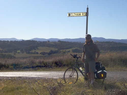
Didn't do any mapping today because of an assignment that needs doing, but I did go shopping and in among the bread and milk a Camelbak HAWG NV somehow got thrown in...

I bought it because 2 750mL bottles just doesn't cut it while mapping in the full Sun. With those bottles rides were limited to 1.5-2hrs and as such I'd regularly have to return home due to a lack of water rather than lack of stamina. Unfortunately amenity=drinking_water's are hard to find at times, mostly because they're not mapped yet and I'm exploring new territory.

Anyway, I went with a Camelbak because a) they're easier to acquire than Platypus packs and b) word is the current Omega HydroTanium bladders are taste free. I've not yet tried it so can't really comment on the taste free bit, but I can say that there is zero plastic smell from any of the bladder components, so there's hope.

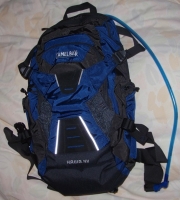
Storage wise the pack is spec'ed at 18L. This is on the small side for backpacks but it's always a compromise between comfort, weight, size and, for a cyclist, aerodynamics. Anyway, there's more than enough room for tubes, tools, phone, GPS and a few sandwiches. Just don't go trying to fit a loaf of bread or bag of chips in it.

The storage space itself in separated into 6 sections, 7 if you count the bladder pocket. These include a large pocket which comprises the bulk of the storage, a smaller pocket in front of that (with several smaller subdivisions within it), 2 "large phone" sized pockets (1 either side), a lose netting section on the front and a water resistant top pocket which is designed for an MP3 player but again could easily hold a phone or GPS.

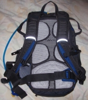
The back of the pack is an excellent airflow webbing which keeps body contact to a minimum to avoid sweat buildup. There's also a stiffened reinforcement membrane which helps to keep the pack away from your body.

Strap wise it's pretty well equipped. There's an elasticated chest strap and a removable waist strap. It even includes little strips of velcro to wind up the loose ends :). There are also 4 straps to squash the pack down.

Lastly, there's a sewn in rain cover tucked away underneath it.

The main downside of this pack is the price. It retails in Australia for $210 so it's not something for a casual user. The bladder comes with a lifetime warranty though and the stitching on the bag looks heavily over-engineered so it's not likely to crap out on you anytime soon. I'm not kidding about the stitching either: stress points have more thread in them than my 80L ex-army pack so they're very strong for a bag of this size.

I'll take it to uni tomorrow and post a follow up evaluation.

Anyway, have some obligatory pics:


Click to view full size!


Click to view full size!

Starting Goonellabah

Posted by Biogenesis_ on 14 July 2009 in English.

Since I've got an assignment due on Thursday there has been excellent motivational influences to get out mapping. So, today Goonellabah got a chunk of blank space populated by streets. The region is fairly hilly, so there was lots of high intensity hill climbing. Also a spoke has worked loose on the rear wheel, probably because hills mean braking and disc brakes mean high spoke tensions.

One thing that was learnt from this ride is that I will need a handlebar riser for the MTB for any rides longer than ~1.5-2hrs. My back and shoulders are a bit achy from holding myself up.

Also, the 1L and 750mL bottles are insufficient for riding more than 2hrs on a sunny day. So, tomorrow I'll start looking at getting a Camelbak. Word is that the newer ones don't have any plastic taste due to some fancy lining in the bladder/tube, hopefully I can find one like that.

Anyway, the changeset can be viewed here.

Location: Goonellabah, Lismore City Council, New South Wales, 2480, Australia

North Lismore

Posted by Biogenesis_ on 13 July 2009 in English.

I hopped on the MTB today and surveyed North Lismore. There are a large number of unpaved roads in the area. Unfortunately the renderers don't show this but labeling them all highway=track would be inappropriate.

Wilsons River is proving annoying to geolocate, mainly because the Landsat imagery is so out of alignment and it's difficult to geolocate due to it's low resolution. There's an ABS boundary along the river but I don't know if it's meant to go down the middle or along one bank. Since the river is ~40m wide it kinda matters.

Short of renting a kayak I'm at a bit of a loss as to how to draw it accurately. I've taken some waypoints to represent the banks underneath the 2 main bridges, maybe them plus some interpolation is the best that's going to happen.

Oh, I also did a few more streets around Lismore Heights, so the list of suburbs which have complete street tracing are:

North Lismore
South Lismore
Lismore
Lismore Heights
East Lismore
Girards Hill

Goonellabah is to follow, with a small chance of Alstonville being traced before I return home early September.

Other partially traced areas in the region include:

Coraki
Casino
Ballina
Woodburn
Evans Head
Byron Bay
etc...

The rural road network to the NE of Lismore is surprisingly complete though :). There are some omissions (which will be filled in during endurance training rides) but they probably stand at ~70% complete, not including dead end roads.

Lastly, I started to trace out landuse=farm, produce=orchard areas last night from landsat/knowledge. There are lots of macadamia and sugar cane plantations in the area and marking them a) makes the map more useful and b) makes it more interesting to look at.

I should stop now and take a shower...

Location: North Lismore, Lismore City Council, New South Wales, 2480, Australia

Bike ride to Coraki

Posted by Biogenesis_ on 11 July 2009 in English. Last updated on 12 July 2009.

Today I did 78.3km on the pushbike cycling to Coraki and back. I surveyed as much road as was practical but ended up having to change my planned route as a road marked as Tertiary on Google Maps ended up being unsealed.

Coraki now has a few streets and all the major roads in/out mapped. I took a swing down the main drag and collected all the shop POIs too. There's still lots of residential streets to go though. I'd estimate the street completion to be ~30-40%.

While JOSM was oped I also traced a few rivers around the place. Evans Head didn't have a full riverbank trace so I drew that in from Landsat. The coastline still looks very rough but the ABS boundary is quite good so I'll ignore that for the time being.

The road changeset can be viewed here.
The rivers changeset can be viewed here.

They're both fairly large areas so the changeset viewer may not work. YMMV.

Edit: Oh, I also left my sunglasses in Coraki. *sigh*, at least they were only from Bunnings.

Location: Coraki Junction, Coraki, Lismore City Council, New South Wales, 2471, Australia

Almost finished Lismore Heights

Posted by Biogenesis_ on 9 July 2009 in English.

After today's very indirect ride home from uni Lismore Heights only has ~500m of streets left unmapped.

The map around Lismore is really starting to look rather beautiful, like something I'd be happy to print out big and have as a poster on my wall.

It's still a long way off being "production ready" though. I'll survey North Lismore tomorrow then get stuck into Goonellabah next week.

They predict better weather next week too, which will be nice. Hopefully it'll clear up enough on Saturday to make for a nice long ride in the countryside.

Today's changeset can be view here.

Location: Lismore Heights, Lismore City Council, New South Wales, 2480, Australia

East Lismore nears completion

Posted by Biogenesis_ on 8 July 2009 in English.

Went for a high intensity ride today, mostly as a result of having to climb up City View Drive in order to access a (fairly upper class) residential area in East Lismore. According to the NSW Dept of Lands topo map the area is at ~140m. What's more several of the streets drop ~50m so in surveying them a bit of a climb is required.

It's a fairly drab day today, got rained on a bit but took refuge in a covered picnic table in Wade Park (it got mapped, search for it :)).

Depending on the weather tomorrow might just be a ride to uni and back. If it clears up a bit I'll have a stab at completing North Lismore. North Lismore is the last flat area which needs surveying.

After that there's ~3 streets which need surveying in Lismore Heights. They lie in the blank area between New Ballina Road and High Street. Then Goonellabah will get attention which should result in several high intensity cardiovascular workouts as it's all >100m above Lismore.

Anyway, today's changeset can be viewed here. (requires zooming in).

Oh, there's also one street which was surveyed which is really new. It appears on the Google Maps photography, but isn't in the street database. Haven't checked if it's in whereis or not. It's only got 2 houses on it so far anyway.

Location: Albert Park, East Lismore, Lismore City Council, New South Wales, 2480, Australia

Country roads around Lismore

Posted by Biogenesis_ on 4 July 2009 in English.

Well I'm stuffed. Did 64km on the bike today tracing out country roads in the name of cycle touring training. I estimate that about 45km of extra roads were added as a result of this exercise.

If the OSM history viewer decides it's able to visualise the changeset it can be seen here.

Otherwise I added: Boat Harbour Road, part of Eltham Road (then added the rest from Landsat), McKenze Road, Pearson Road, Cowlong Road, Alphadale Road and Tregeagle Road.

Cameron Road (joins Boat Harbour Road and Cowlong Road) was added as it's an ABS suburb boundary.

I've done 270km on the pushbike since moving to Lismore 8 days ago. Time to do nothing for a few days :p.

For some reason the osmarender layer is playing up. It's viewable through informationfreeway.org if you select the Firefishy proxy though.

If anybody's interested the motionbased.com analysis of the (very simplified) GPX track is here

Also, I feel like throwing in this photo of me on the road (yeah, the flash fired to try to fill-flash...all it did was blow out the reflective strips :p):

Location: Pearces Corner, Goonellabah, Lismore City Council, New South Wales, 2480, Australia

South Lismore

Posted by Biogenesis_ on 3 July 2009 in English.

Did a few more streets in South Lismore this afternoon. Mainly because it's dead flat and I was after an easy ride.

The area is a bit of a hole. Basically it floods easily so it's either cheap residential or industrial land.

There's still some stuff to do on the East side of the Bruxner Highway such as marking the Bunnings, parks etc, but at least the bulk of the streets on the West side of the highway are now done.

Probably doing hill sprints tomorrow, so the rest of East Lismore might get done.

Has anybody else noticed that mapping is really hard on a pushbike? The constant stop/start nature of it is seriously chewing into the life of the rear tyre and cassette. My current rear tyre (Specialized flack jacket 700x25C) looks to be about half way through it's life and it's only done 300km! Same with the rear cassette, it's on it's second chain (also replaced 300km ago) and is significantly more worn than it was when the chain was installed.

Location: South Lismore, Lismore City Council, New South Wales, 2480, Australia

Cycled into uni today for my first lecture and surveyed another chunk of East Lismore on the way home. Ended up doing 30km for the day. If I do 10km tomorrow it'll make 200km for the 7 days to date total :).

Anyway, the OSM history viewer linked to in previous diary entries isn't working for the today's changeset. So, lets just say that it was everything between Oakley Avenue, Wyrallah Road and the edge of the suburb. The most fun bit was surveying the stormwater drains in the area. I also did a fairly detailed survey of the kid's bike track in Wade Park.

The rest of East Lismore (the landuse=residential area to the West of Wyrallah Road) is basically a big hill, but since I'm due for a high intensity ride tomorrow I'll give it a stab.

Location: East Lismore, Lismore City Council, New South Wales, 2480, Australia

Did 24km on the bike today, almost all of which was on new streets. I mainly aimed for hilly terrain as the previous 2 days had contained easy going rides.

The changeset can be viewed here (zoom in).

Oh, and if anybody gets a JOSM error "placeholder ids must be unique for created elements" make sure you haven't got any repeated elements in new relations. I spent a while racking my brain and googling to work out what had gone wrong to get this error message, turned out a no right turn restriction had 6 members because each member was entered twice.

Tomorrow I cycle in for my first actual uni lecturer, a good excuse for more unmapped street surveying near SCU.

Location: Albert Park, East Lismore, Lismore City Council, New South Wales, 2480, Australia

I did some landsat tracing around Lismore last night and marked out the bulk of the landuse in the area. So far Goonellabah, to the East, is unmarked as it's difficult to do without the bulk of the streets marked in first.

There's still some tweaking to do, for instance all the industrial areas are currently marked as residential, but having the bulk of it marked in has made the map loop significantly more complete.

I've also taken a bit of an interest in water drainage. Being a flood prone area it will be interesting to mark in the major drains, creeks etc. Maybe even the levee walls.

Location: Lismore, Lismore City Council, New South Wales, 2480, Australia