What is this why is there a diary
Diary Entries in English
Recent diary entries
Hi again,
It’s just 2 days before this diary post was published, and I’m very happy to announce that I will start proposing tags again. I already have exciting ideas and hopefully the community approves them.
EDIT: Next proposal will hopefully come tomorrow or this week, stay tuned!
Ewrt1
Posted by yvonnepaje on 24 March 2024 in English.
Shape my future with OSM Mapping and Youthmappers: Post Graduation Blog
A few months after my graduation, I find myself questioning how prepared I am to face the real world. Will the knowledge I acquired in school, particularly regarding organizational management, truly benefit me? Or could OSM mapping play a pivotal role in shaping my career path?
But how exactly do OSM mapping and YouthMappers influence career decisions?
Through mapping activities, I've gained critical thinking, problem-solving, and collaborative skills—qualities highly sought after in today's job market. Little did I anticipate that within these communities, I would uncover aspects of myself previously concealed. Leadership, once abstract, found a nurturing environment within the supportive ecosystem of YouthMappers. It was here that I discovered my capacity to lead, inspire, and effect change.
YouthMappers became my haven for personal development more than merely a platform. With every mapping project, my confidence increased. Although it was scary at first, public speaking became a skill I developed whenever I got the chance. Our community's response to our influence extended well beyond the boundaries of our maps, creating a lasting impression on people's emotions.
These days, certificates appear on my résumé as credentials as well as proof of my experience. They talk about the hours spent creating, learning, and working together. With the support of mentors and the friendship of other mappers, I learned things that went beyond what was found in textbooks.
Today, I stand not just as a graduate, but as a leader forged in the crucible of YouthMappers. I have the privilege to educate others on utilizing OSM mapping for change. Once reticent, my voice now brims with the fervor of someone who has experienced the potency of unity in action.

Welcome to my second OpenStreetMap NextGen development diary. I am ready to highlight this week’s progress — and there was a lot 👷!
You can subscribe to my diary updates on RSS here:
osm.org/user/NorthCrab/diary/rss
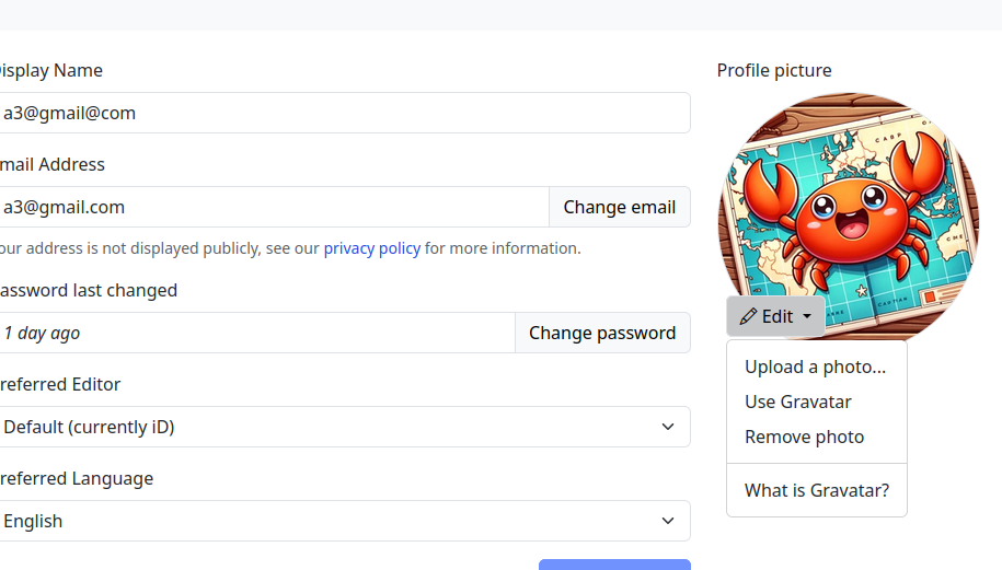
Finished Settings Page
Last week I showcased initial progress on the new settings page for OpenStreetMap. This week, I’ve finished it. Here’s what’s new. Keep in mind that if you believe some features should be done differently, there will be a period of public testing where I’ll collect this kind of feedback 😉.
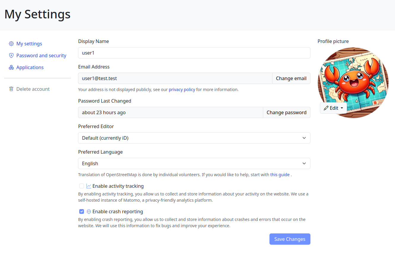
Click here to view it in full screen.
Aside from the improved layout, I’ve introduced two notable changes. First, the application language selection has been redesigned; it’s now a simple dropdown selector. I believe the current system (where you input locale names by hand) is difficult for less technical people to understand, and I want to make the website more accessible to everyone!

Participants shaded by umbrellas, to protect them from the sun, while collecting fresh geodata with FieldPapers. UP Mindanao Campus, Davao City. Photo shared by UPMinYouthMappers in their SNS post.
While visiting the family down south, I had a chance to join UP Mindanao’s own chapter, UPMin YouthMappers while their College (of Science & Maths) was celebrating Pi Day. The coordinator asked if I have any preference for the name of the activity we had in mind, and I suggested Map-Pi Day.

I’ve been kind of bouncing around various projects the past week.
I have tentatively completed sidewalk mapping in Emsworth Borough, and have moved on to adding sidewalks and pedestrian crossings in Avalon. I also did a little revamp of the playground adjacent to the Avalon Elementary School. It turns out that as I was extending the sidewalk along California Avenue, I met up with some previously mapped sidewalk bits, which is nice. Although they have not added a lot of the tags I do, so I will circle back to make this area a little more seamless with what I’ve added to the west.
I’m planning to go through Ben Avon and Emsworth to tag pedestrian crossings and curbs a little more consistently; I had been changing the way I tag things as I went based on new information/methodology.
I got kind of distracted when I realized that Pittsburgh Botanical Garden needed some updating due to their recent renovations. I was able to add the new visitor center and update a lot of the concrete paths, but I have some question marks as to the accuracy of some of the other paths on the property. I will take some good GPX tracks the next time I am there (likely this week). I especially want to see what progress has been made on the feature that is to the southwest of the Lotus Pond. I will also try to acquire a more precise/accurate/official property map from PBG, because the pictoral one on their website is great for ordinary wayfinding, but wholly inadequate in precisely showing where things are.
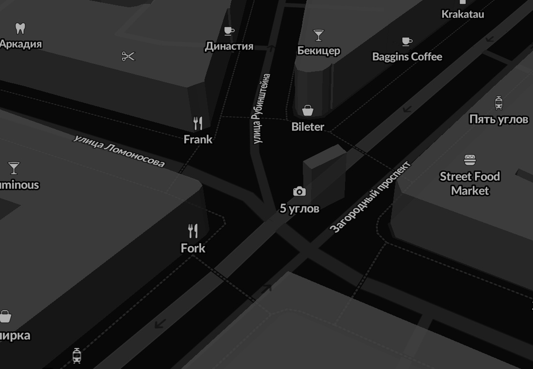
There’s lots of data stored in OSM about bus stops, but often maps and apps created with OSM data don’t make much use of it (with OsmAnd being the notable exception). For here’s a bus stop as shown by OSM Carto:
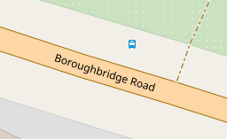
You can see that it’s a bus stop, and you’d be able to see the name if you could zoom in a bit more. However, in OSM there’s actually lots more information. For the map styles that I look after (both web-based raster maps and for Garmin devices) I tried to add a bit more detail. Here’s the result:
Today I decided to introduce a new format for sharing OpenStreetMap-NextGen development progress with the community. I’ll post weekly/bi-weekly updates highlighting changes and the current project status. Since this is the first update, I’ll cover some recent highlights.
You can subscribe to my diary updates on RSS: link.
New Settings Page (⭐ Highlight)
I’ve begun migrating the settings/preferences section. My goal is to streamline this experience, as I’ve found the current system a bit complex. Surprisingly, many users don’t know it’s possible to change the default editor — I want to make this more obvious.
A new menu on the left of the screenshot (hidden, not yet finished) will provide clear navigation between general, 2FA, OAuth, and other settings.
This page is still work in progress. I intend to add a help text explaining how to contribute to translations and that the translations are made by the community.
Eco Mappers OSM Rwanda ODD,
As we commemorated International Open Data Day and International Women’s Day, we embarked on a journey to intertwine these essential themes for equitable development. On Saturday, March 9, 2021, amidst a global celebration of Open Data Day, our event in Rwanda stood as a beacon of empowerment, bringing together over 50 enthusiastic participants eager to delve into the world of open data.

Before delving into the event’s highlights, it’s crucial to acknowledge the significance of Open Data Day. With more than 60 events worldwide, it underscores the global community’s commitment to promoting open data’s usage and accessibility. Thanks to the support from key funders, including the Open Knowledge Foundation, these events serve as catalysts for change, fostering collaboration and innovation.
Ahead of our event,

Last quarter, a “getting to know you” survey was made available to the local OpenStreetMap (OSM) communities in the Philippines, to help us better understand the current state of the active contributor base of our community.
The original idea was to run it just for the membership of local YouthMapper Chapters (YMC), but eventually it was made available to anyone who contributes to OSM in the Philippines, here or abroad, regardless of citizenship or affiliations.
I’m sharing my observations from the responses made by the participants who participated in the survey, again, majority of whom comprised of local YMC respondents.
Click on the images, to open them in full resolution in a separate tab.
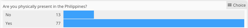
Are you physically present in the Philippines?
While 86% of the mappers reported that they are physically in the country, mappers coming from elsewhere at 14% was bigger than I expected.
Which of the following best describe your primary undertaking in the OSM project?
Posted by Raquel Dezidério Souto on 16 March 2024 in English.
Last updated on 30 April 2024.
🍾 YouthMappers UFRJ celebrates its first year!
The YouthMappers UFRJ (Rio de Janeiro, Brasil) completed one year on March 14th, 2024.
And to celebrate this special date, we interviewed Dr. Rogério Luís R. Borba, analyst at the IBGE Foundation and manager of the Brazilian Geospatial Data Directory (“Diretório Brasileiro de Dados Geoespaciais, DBDG) of the Brazilian National Spatial Data Infrastructure (“Infraestrutura Nacional de Dados Geoespaciais”, INDE).
🎥 Watch on IVIDES.org’s YouTube channel.
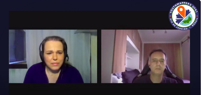
Rogério talked to us about the importance of open data and how the collaborative mapping can helps Brazil in the production of official cartographic data. The interview was conducted by Dr. Raquel Dezidério Souto and all details can be found at:
Happy Burger 11309 Midlothian Turnpike Richmond, VA 23235
As part of my commitment to OpenStreetMap-NextGen migration, I undertook a comprehensive security review of the existing OpenStreetMap website. I followed the principles of coordinated vulnerability disclosure, working directly with the maintainers to responsibly report my findings. Today, I’m making the details of this process public and verifying the status of the fixes.
Disclosure Timeline
- 2023-11-04 - Contacted Ruby security maintainers & disclosed the timeline publicly
- 2023-11-08 - Maintainers acknowledged the report
- 2023-12-04 - Reported additional vulnerabilities with a 3-month deadline
- 2023-12-06 - Maintainers acknowledged the additional report
2024-03-02 - Publicize vulnerability details- 2024-03-15 - Publicize vulnerability details
1. Plain-Text Authentication Token Storage
Authorization tokens (oauth, session, user tokens) are stored in plain text. Read access to the database allows full impersonation of any user.
Status as of 2024-03-15: Partially vulnerable (oauth still depends on plain text storage)
NextGen Codebase Status: Fixed (all authorization tokens and credentials are hashed or encrypted for secure storage)
2. Insecure Email Reply Address Tokenization
The tokens used to ensure the authenticity of email replies are too short (24-bit), making them susceptible to brute-force attacks. An attacker could potentially guess the token and impersonate a legitimate user in email conversations. This vulnerability is especially dangerous if the attacker already has access to a conversation’s metadata (allowing for complete security bypass).
Status as of 2024-03-15: Fixed (now with 48-bit security)
NextGen Codebase Status: Fixed (128 or 256-bit security; undecided)
3. Unbounded GPX Extraction Denial of Service
Apparently, OSM in Vietnam is in a very poor condition. And one of the reasons would be the absence of several nature reserve areas, even compared to the two neighboring Indochinese brothers, Laos and Cambodia. Despite the fact that the Department of Forestry has published a document stating that there are 34 national parks and 56 nature reserves, until now (15 March) only half of them have been mapped to OSM.
Here’s the list:
National parks
- VQG Ba Bể/Ba Be NP
- VQG Ba Vì/Ba Vì NP
- VQG Bạch Mã/Bạch Mã NP
- VQG Bái Tử Long/Bái Tử Long NP
- VQG Bến En/Bến En NP
- VQG Bidoup - Núi Bà/Bidoup - Núi Bà NP
- VQG Bù Gia Mập/Bù Gia Mập NP
- VQG Cát Bà/Cát Bà NP
- VQG Cát Tiên/Cát Tiên NP
- VQG Chư Mom Ray/Chư Mom Ray NP
- VQG Chư Yang Sin/Chư Yang Sin NP
- VQG Côn Đảo/Côn Đảo NP
- VQG Cúc Phương/Cúc Phương NP
- VQG Du Già - Cao nguyên đá Đồng Văn/Du Già - Đồng Văn Karst Plateau NP
- VQG Hoàng Liên/Hoàng Liên NP
- VQG Kon Ka Kinh/Kon Ka Kinh NP
- VQG Lò Gò - Xa Mát/Lò Gò - Xa Mát NP
- VQG Mũi Cà Mau/Mũi Cà Mau NP
- VQG Núi Chúa/Núi Chúa NP
- VQG Phja Oắc - Phja Đén/Phja Oắc - Phja Đén NP
- VQG Phong Nha - Kẻ Bàng/Phong Nha - Kẻ Bàng NP
- VQG Phú Quốc/Phú Quốc NP
- VQG Phước Bình/Phước Bình NP
- VQG Pù Mát/Pù Mát NP
- VQG Sông Thanh/Sông Thanh NP
- VQG Tà Đùng/Tà Đùng NP
- VQG Tam Đảo/Tam Đảo NP
- VQG Tràm Chim/Tràm Chim NP
- VQG U Minh Hạ/U Minh Hạ NP
- VQG U Minh Thượng/U Minh Thượng NP
- VQG Vũ Quang/Vũ Quang NP
- VQG Xuân Sơn/Xuân Sơn NP
- VQG Xuân Thủy/Xuân Thủy NP
- VQG Yok Đôn/Yok Đôn NP
Nature reserves
Nature reserves with official “Nature Reserve” title
Official “Nature Reserve” title refers to the fact that these areas have their own management board (ban quản lý) and is usually a division of the provincial departments of agriculture and rural development (Sở Nông nghiệp và Phát triển Nông thôn). These includes:
Posted by umbraosmbr on 14 March 2024 in English.

Posted by umbraosmbr on 14 March 2024 in English.
presentation of the Mapeaia Belém project to the Brazilian Openstreetmap community

we present the Mapeia Belém project to the Brazilian openstreetmap community, which is an initiative of UMBRAOSM União dos Mapeadores Brasileiros do Openstreetmap and partners such as Meninas da GEO, Capitulos Youthmappers and other groups and in addition to the Brazilian Openstreetmap community and aims to update data in city of Belém for the Major Events that the city will host in 2024 and 2025 such as FOSS4G and COP 30.
The key “name” is one of the 10 most frequently used characteristics of objects - according to Taginfo 100 million times. It is probably also the tag with the most errors. A random sample in my neighbourhood showed an error rate of 8.4% (N=1092). Possible reasons:
- lack of knowledge
- misunderstanding
- tag missing
The proposal relates to point 2, possible misunderstandings regarding the meaning of the “name” tag.
Current Wiki structure
The main article names lists 14 different keys of the proper name, differentiates them from each other and from non-proper names and gives many examples. The article is quite extensive with 29k characters.
Of the 14 keys, 5 keys do not have their own wiki page: int_name, loc_name, nat_name, reg_name and nickname.
The article on the key name is similar to the main article names, only somewhat shorter. It is still quite extensive with 18k characters. All other articles are short.
Issues Main article “names”
Readability.
The text is very extensive and therefore requires perseverance. However, it deals with all aspects of name keys in detail and consistently. Many examples illustrate the basic idea.
Issues key:name
Readability, redundancy, clarity.
The text for the key name is very long at 18k characters, the essentials are lost in the sea of words. Much of it is a repetition of information that is already available elsewhere:
- The “values” section is almost completely contained in the main article.
- The “Variants” table is already completely contained in the main article.
- The table of language subkeys covers more than 3 screen pages and is also fully covered on the “Multilingual names” page.
- The sections “Road names” and “Additional data” are also already included in the main article. Only the sentence with “strapline” is supplementary.
In addition to the high redundancy, the text is also blurred. The core - the proper name - is not mentioned at all. The explanations lead to problematic statements.

Did you hear?
We plan to bring StreetComplete to iOS!
For all that have been eagerly awaiting this to happen, there is more good news, however!
Prototype Fund
Posted by Eka Diweti on 13 March 2024 in English.
Last updated on 13 April 2024.
The OpenStreetMap Foundation had quite recently launched a worldwide membership campaign with the objective of growing and diversifying OSMF membership in regions where there are very low or no OSMF members. And I am proud to say that I was/am part of this campaign. I should say that it is also my very first time volunteering for the OpenStreetMap Foundation and the experience has been & continues to be very enriching to say the least. In late January, I had responded to a call for volunteers & campaigners to help grow OSMF membership on Slack & since then, I’ve been part of a very diverse, talented & committed group of campaigners & volunteers.
On the first few virtual meet-ups via Google meet, I had promptly signed up for the visual comms/mapmakers role as I believed I could use whatever little designing skills & experiences I had to aid in creating & designing comms material for the campaign. In doing so, I had been thrown into a mix of incredible volunteers from around the world. Our work as visual comms/mapmakers volunteers had revolved around creating posters, pubmats, infographics, maps, etc. and these materials feature a lot about the OpenStreetMap Foundation, testimonials, how to join, membership types, why join, etc. However, generating these materials wasn’t an easy feat as the process often involved planning, a lot of discussions, facilitating, reviewing, and amending the materials as per suggestions/recommendations from the OSMF Board.
I believe that this volunteering opportunity has helped me grow in ways I wouldn’t have imagined because in the short period of only two months, I have learnt a lot about community, having being part of a group with shared or common interest but also acknowledging the different ideas, strengths & capabilities that each one of us had & brought to the table allowed us to effectively work together to bring about the outputs we were tasked to deliver.