Loading...
Way: Sentier des Falaises du Devenson (85325154)
Version #19
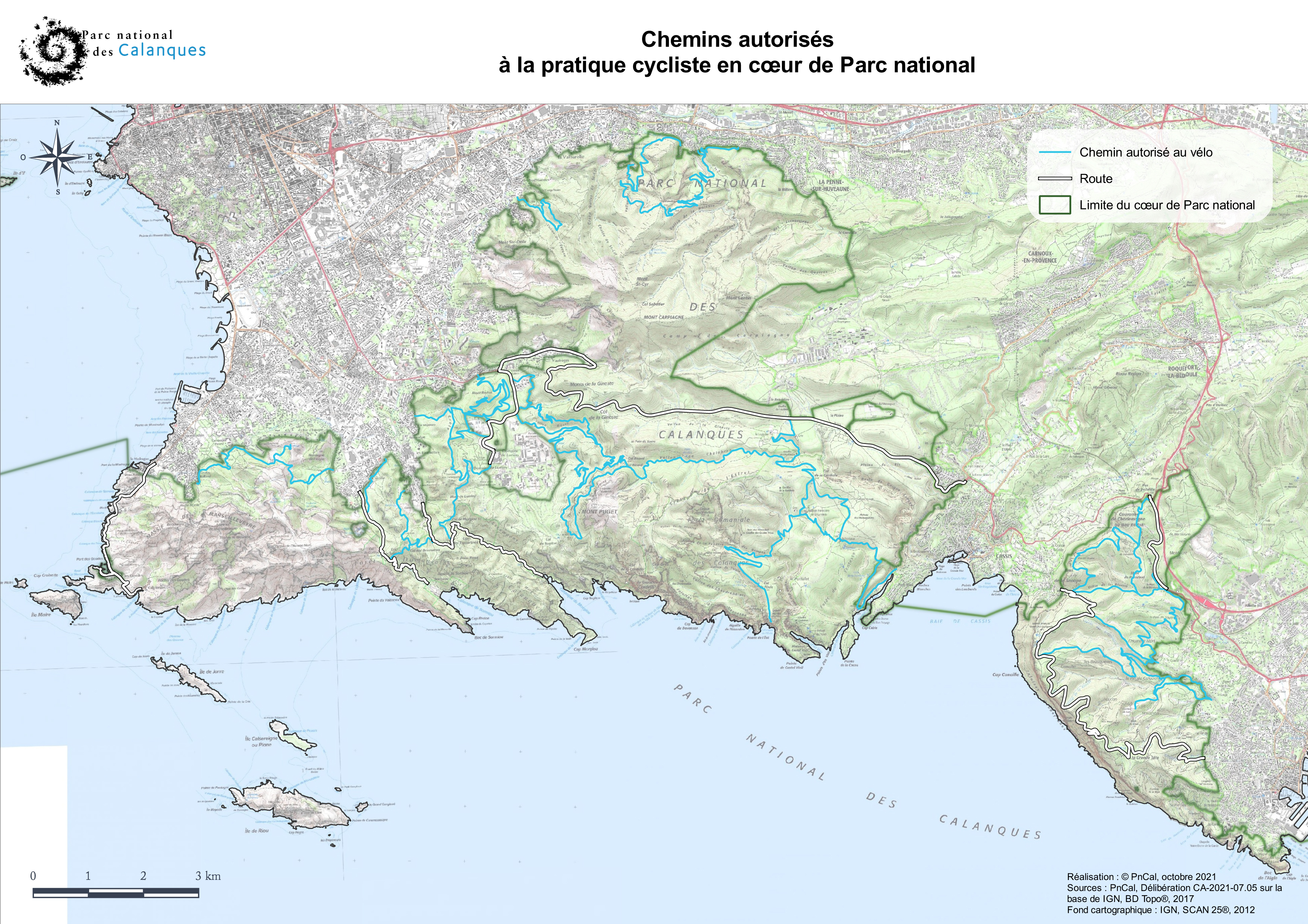
DWG issue - Updating trail access: http://www.calanques-parcnational.fr/sites/calanques-parcnational.fr/files/thumbnails/image/carte_velo.jpg
Tags
| bicycle | no |
|---|---|
| highway | path |
| hiking | yes |
| name | Sentier des Falaises du Devenson |
| name:oc | Draiòu dau Bauç dau Defenson |
| note | Balisage en barre vert (8). |
| sac_scale | mountain_hiking |
| source:name:oc | ieo-bdtopoc |
| trail_visibility | excellent |
| trailblazed | yes |
Part of
1 relation
- Relation Vert 8 (4018771)
Nodes
213 nodes
- 607963476 (part of way Sentier des Falaises du Devenson (1055222485))
- 2555034967
- 9696336834
- 2555034966
- 1324367016
- 1324366676
- 9696336832
- 607963477
- 9696336919 (part of way Couloir des Hurluberlus (1239708068))
- 2555034964
- 10676566092
- 1324366145
- 9696336831
- 9696336830
- 2555034962
- 607963478
- 5014587893
- 1324367100
- 10676566093
- 1324366825
- 607963480
- 10676566094
- 1324366114
- 9696336827
- 9696336828
- 9696336829
- 1324367170
- 9696336824
- 9696336825
- 1324366258
- 1324366790
- 10676566095
- 10676566096
- 10676566097
- 1324367079
- 3453823066 (part of way 338305148)
- 10676566101
- 9696336819
- 10676566102
- 1324366882
- 10676566104
- 10676566103
- 1324366402
- 10676621109
- 1324366571
- 1324367239
- 9696336805
- 607963481
- 9696336806
- 9696336808
- 9696336807
- 1324366028
- 9696336809
- 9696336813
- 9696336811
- 9696336812
- 9696336810
- 607963482
- 9696336814
- 9696336816
- 1324367027
- 1324366168
- 1324366688
- 1324367115
- 10676621110
- 9696336817
- 9696336818
- 607963484
- 9696318202
- 607963485
- 9696318201
- 9696318200
- 1324366830
- 9696318199
- 9696318203
- 9696318204
- 1324366304
- 1324367096
- 1324366805
- 9696327407
- 9696327406
- 1324366281
- 607963487
- 9696327408
- 9696327409
- 607963490
- 9696327410
- 9696327411
- 9696327412
- 5014587892
- 9696327414
- 9696327413
- 1324367177
- 10676621113
- 10676621112
- 607963493
- 9696327415
- 607963495
- 9696318197
- 9696318198
- 607963497
- 9696327416
- 9696336717
- 9696336718
- 10676621114
- 10676621115
- 607963500
- 9696336721
- 9696336720
- 9696336719
- 9696336722
- 607963502
- 9696336723
- 1324366415
- 9696336724
- 9696336725
- 9696336726
- 1324366887
- 9696336728
- 9696336727
- 9696336729
- 607963504
- 10676621116
- 10676621117
- 10676621118
- 9696336730
- 607963414
- 9696336732
- 9696336731
- 10676621119
- 607963415
- 9696336733
- 607963416
- 9696336734
- 9696336735
- 1324367054
- 9696336736
- 316846374
- 9696336737
- 1324366734
- 316846373
- 9696336738
- 9696336739
- 9696336740
- 9696336741
- 316846372
- 9696336743
- 9696336742
- 1324366225
- 9696336744
- 316846370
- 1324367035
- 9696336745
- 9696336746
- 9696336747
- 9696336748
- 9696336749
- 10676621128
- 316846369 (part of way 28819878)
- Col de l'Eissadon (1324366701) (part of way (Accès secteur escalade) (380548364))
- 10676621121
- 316846366
- 10676617017
- 10676617018
- 10676617014
- 10676617016
- 10676617015
- 316846363
- 316846362
- 10676617019
- 10676617020
- 1324366181
- 10676617021
- 1324367128
- 10676617022
- 10676617023
- 10676617025
- 10676617024
- 316846360
- 10676617026
- 10676617027
- 316846359
- 10676617028
- 10676617029
- 1324366850
- 10676617030
- 10676617031
- 10676617032
- 316846358
- 10676617033
- 316846357
- 10676617034
- 10676617035
- 10676617036
- 10676617037
- 10676617039
- 316846355
- 10676617038
- 10676617040
- 10676617041
- 316846354
- 10676617042
- 10676617043
- 10676617044
- 316846353
- 10676617045
- 10676617046
- 316846351
- 10676617048
- 10676617047
- 10676617049
- 10676617050
- 1324366153 (part of ways 132049432 and 117581300)
Welcome to OpenStreetMap!
OpenStreetMap is a map of the world, created by people like you and free to use under an open license.
Hosting is supported by Fastly, OSMF corporate members, and other partners.

| https://openstreetmap.org/copyright | https://openstreetmap.org |
| Copyright OpenStreetMap and contributors, under an open license | |