Way History: A 7 (292375487)
Version #8
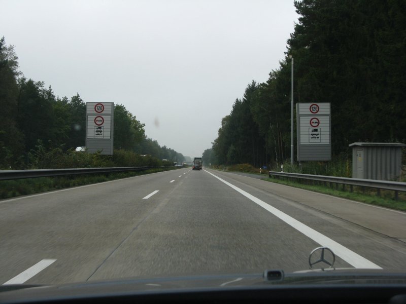
BAB 7 zwischen Bad Fallingbostel und Soltau hat seit Jahren keine Freigabe der Standstreifen als Fahrspur mehr. Die Schilder hierfür wurden nun entfernt und es wurden neue 120-Schilder aufgestellt.
- Edited by OSM_RogerWilco
- Changeset #138620984
Tags
| bdouble | yes |
|---|---|
| highway | motorway |
| image | http://www.autobahn-bilder.de/images/A7%20Ri%20Kempten/HH-WU/IMG_7046.JPG |
| int_ref | E 45 |
| lanes | 3 |
| lit | no |
| maxspeed | 120 |
| maxspeed:type | sign |
| oneway | yes |
| placement | right_of:1 |
| ref | A 7 |
| shoulder | no |
| surface | concrete |
| turn:lanes | none|none|slight_right |
| width | 11 |
Nodes
4 nodes
- 2959289508 (part of way A 7 (27208242))
- 4881546940
- 11013956857
- 3018302851 (part of way A 7 (297929542))
Version #7
highway details A 7
Tags
| bdouble | yes |
|---|---|
| highway | motorway |
| image | http://www.autobahn-bilder.de/images/A7%20Ri%20Kempten/HH-WU/IMG_7046.JPG |
| int_ref | E 45 |
| lanes | 3 |
| lit | no |
| maxspeed | 120 |
| maxspeed:conditional | 100 @ (hard_shoulder_running) |
| maxspeed:variable | yes |
| note | Der rechte Standstreifen wird bei Bedarf als Fahrspur freigegeben und dann durch Kameras überwacht. Die maxspeed reduziert sich dann auf allen Fahrspuren von 120 Kmh auf 100 Kmh. Dies wird durch Signale angezeigt, siehe image. User:smarties |
| oneway | yes |
| placement | right_of:1 |
| ref | A 7 |
| shoulder | no |
| surface | concrete |
| surveillance | public |
| turn:lanes | none|none|slight_right |
| width | 11 |
Nodes
4 nodes
- 2959289508 (part of way A 7 (27208242))
- 4881546940
- 11013956857
- 3018302851 (part of way A 7 (297929542))
Version #6
highway cycleway lanes maxspeed maxspeed:lanes destination destination_sign relation sign traffic_sign turn turn:lanes backward forward
Tags
| bdouble | yes |
|---|---|
| highway | motorway |
| image | http://www.autobahn-bilder.de/images/A7%20Ri%20Kempten/HH-WU/IMG_7046.JPG |
| int_ref | E 45 |
| lanes | 2 |
| lanes:conditional | 3 @ (signal) |
| lit | no |
| maxspeed | 120 |
| maxspeed:conditional | 100 @ (signal) |
| note | Der rechte Standstreifen wird bei Bedarf als Fahrspur freigegeben und dann durch Kameras überwacht. Die maxspeed reduziert sich dann auf allen Fahrspuren von 120 Kmh auf 100 Kmh. Dies wird durch Signale angezeigt, siehe image. User:smarties |
| oneway | yes |
| ref | A 7 |
| surface | concrete |
Nodes
3 nodes
- 2959289508 (part of way A 7 (27208242))
- 4881546940
- 3018302851 (part of way A 7 (297929542))
Version #5
highway cycleway lanes maxspeed maxspeed:lanes destination destination_sign relation sign traffic_sign turn turn:lanes backward forward
Tags
| bdouble | yes |
|---|---|
| highway | motorway |
| image | http://www.autobahn-bilder.de/images/A7%20Ri%20Kempten/HH-WU/IMG_7046.JPG |
| int_ref | E 45 |
| lanes | 2 |
| lanes:conditional | 3 @ (signal) |
| lit | no |
| maxspeed | 120 |
| maxspeed:conditional | 100 @ (signal) |
| note | Der rechte Standstreifen wird bei Bedarf als Fahrspur freigegeben und dann durch Kameras überwacht. Die maxspeed reduziert sich dann auf allen Fahrspuren von 120 Kmh auf 100 Kmh. Dies wird durch Signale angezeigt, siehe image. User:smarties |
| oneway | yes |
| ref | A 7 |
| surface | concrete |
Nodes
2 nodes
- 2959289508 (part of way A 7 (27208242))
- 3018302851 (part of way A 7 (297929542))
Version #4
DE: Niedersachsen: A7 Munster -Walsrode, Geschwindigkeit 120 aktualisiert
Tags
| bdouble | yes |
|---|---|
| highway | motorway |
| int_ref | E 45 |
| lanes | 3 |
| lit | no |
| maxspeed | 120 |
| oneway | yes |
| ref | A 7 |
| surface | concrete |
Nodes
2 nodes
- 2959289508 (part of way A 7 (27208242))
- 3018302851 (part of way A 7 (297929542))
Version #3
added bdouble variables
Tags
Nodes
2 nodes
- 2959289508 (part of way A 7 (27208242))
- 3018302851 (part of way A 7 (297929542))
Version #2
Verlauf korrigiert
- Edited by Eckhart Wörner
- Changeset #24769764
Tags
Nodes
2 nodes
- 2959289508 (part of way A 7 (27208242))
- 3018302851 (part of way A 7 (297929542))
Version #1
where maxspeed=120 is and where not
Tags
Nodes
2 nodes
- 2959289508 (part of way A 7 (27208242))
- Soltau-Süd (491592) (part of ways A 7 (27208245), A 7 (297929542), and 15126545)
Welcome to OpenStreetMap!
OpenStreetMap is a map of the world, created by people like you and free to use under an open license.
Hosting is supported by Fastly, OSMF corporate members, and other partners.
| https://openstreetmap.org/copyright | https://openstreetmap.org |
| Copyright OpenStreetMap and contributors, under an open license | |