Loading...
Way: Sentier des Falaises du Devenson (117581821)
Version #21
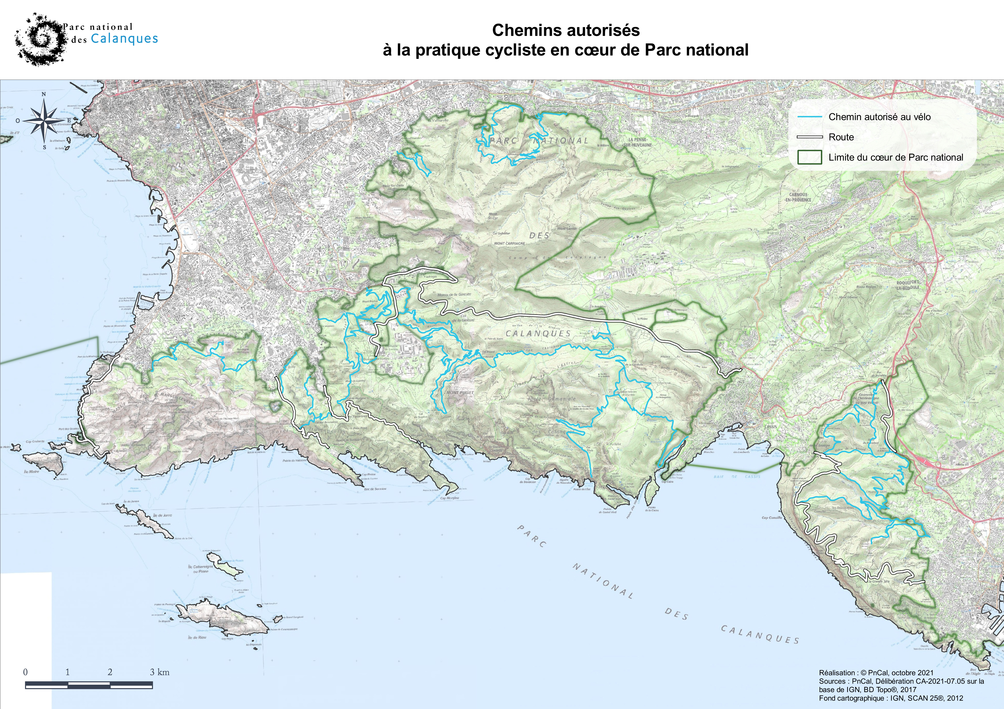
DWG issue - Updating trail access: http://www.calanques-parcnational.fr/sites/calanques-parcnational.fr/files/thumbnails/image/carte_velo.jpg
Tags
| bicycle | no |
|---|---|
| highway | path |
| hiking | yes |
| name | Sentier des Falaises du Devenson |
| name:oc | Draia dau Serre de Deversan |
| note | Balisage en barre vert (8), blanc-rouge. |
| sac_scale | mountain_hiking |
| trail_visibility | excellent |
| trailblazed | yes |
Part of
3 relations
- Relation 11862673
- Relation Sentier de Grande Randonnée 98 (2681053)
- Relation Vert 8 (4018771)
Nodes
185 nodes
- 989181225 (part of ways 85325143 and 107451073)
- 7158518425
- 7158518427
- 7158518426
- 9696318167
- 9696318166
- 7158518428
- 9696318165
- 9696318164
- 9696318163
- 9696318168
- 7158518424
- 607963445
- 9696318170
- 9696318169
- 9696318171
- 9696318172
- 9696318173
- 607963447
- 7158518423
- 7158518421
- 7158518420
- 7158518422
- 9696318174
- 1324366512
- 10676595732
- 9696318175
- 9696318176
- 9696318177
- 7158518418
- 9696318178
- 7158518419
- 7158518417
- 7158518416
- 607963450
- 7158518415
- 7158518414
- 9696318180
- 9696318179
- 607963452
- 9696318181
- 7158518413
- 7158518412
- 9696318182
- 7158518411
- 9696318183
- 7158518410
- 989181240
- 7158518409
- 989181193
- 7158518406
- 7158518405
- 9696318184
- 7158518404
- 7158518403
- 9696318185
- 7158518407
- 989181526
- 7158518408
- 989181614
- 7158518402
- 7158518401
- 7158518400
- 989181416
- 7158518399
- 7158518398
- 9696318186
- 7158518397
- 989181510
- Col des Charbonniers (3454306910) (part of way Cheminée du CAF (1055146928))
- 9696318187
- 7158518393
- 989181294
- 7158518394 (part of way 338356342)
- 9696318188
- 607963454
- 10676595733
- 9696318190
- 9696318189
- 989181219
- 7158518392
- 7158518391
- 989181550
- 607963455
- 989181186
- 7158518390
- 989181408
- 9696318191
- 7158518389
- 9696318193
- 9696318194
- 9696318192
- 2555035001
- 10676595734
- 7158518388
- 9696318195
- 9696318196
- 989181290
- 10676595739
- 10676595738
- 10676595737
- 10676595736
- 2555034999
- 10676595735
- 7158518387
- 2555034997
- 2555034996
- 2555034994
- 10676595740
- 2555034992
- 7158518386
- 989181613
- 10676595742
- 10676595741
- 989181561
- 989181715
- 989181507
- 7158518385
- 7158504484
- 607963461
- 989181356
- 7158504482
- 7158504481
- 7158504483
- 607963463
- 9696350914
- 7158504480
- 9696350915
- 989181254
- 10676600628
- 989181702
- 607963465
- 7158504478
- 2555034985
- 7158504477
- 10676600629
- 10676600630
- 989181557
- 607963466
- 1324365992
- 7158504476
- 1324366996
- 607963467
- 1324366649
- 7158504475
- 2555034979
- 10676600631
- 1324365965
- 1324366980
- 7158504474
- 1324366622
- 7158504473
- 2555034971
- 607963468
- 607963470
- 1324366086
- 7158504472
- 989181442
- 7158504471
- 1324366758
- 7158504470 (part of way 1236343254)
- 1324367064
- 10676600633
- 989181522
- 989181324
- 10676600632
- 1324366234
- 7158504469
- 607963471
- 7158504464
- 7158504465
- 7158504466
- 7158504467
- 7158504463
- 7158504462
- 607963473
- 7158504461
- 1324367158
- 7158504460
- 7158504459
- 989181646
- 7158518241
- 7158518240
- 989181657
- Col du Devenson (3453823062) (part of ways Sentier des Falaises du Devenson (1152383488) and Petit couloir (888238024))
Welcome to OpenStreetMap!
OpenStreetMap is a map of the world, created by people like you and free to use under an open license.
Hosting is supported by Fastly, OSMF corporate members, and other partners.
| https://openstreetmap.org/copyright | https://openstreetmap.org |
| Copyright OpenStreetMap and contributors, under an open license | |