manings's Comments
| Changeset | When | Comment |
|---|---|---|
| 61420020 | over 7 years ago | This edits seems to have deleted a lot of POIs. Can you clarify the intent? |
| 60641082 | over 7 years ago | Wrong changeset comment. I added service roads around the neighbourhood. |
| 60563050 | over 7 years ago | @peter, thanks for the revertion. I clearly made a mistake here. > elaborate on the rationale for making this section of Southeast Division Street a dual-carriageway I interpreted the no passing zone as indicated in the road marking as a proxy for dual-carriageway since it implies "crossing the line is prohibited". I am probably wrong. I did tried as much as I can to retain the relations, but I obviously did not do a good job using iD. I'll be careful next time. |
| 60117308 | over 7 years ago | Fixed some errors from this changeset. See: changeset/60237156
|
| 59474972 | over 7 years ago | I think this was accidental, fixed here: changeset/59486397 |
| 54200864 | about 8 years ago | Thanks you, I fixed it here: changeset/54316775 |
| 53664525 | about 8 years ago | hi sheinna, we noticed your edits was part of an organized edits, we documented it here: https://github.com/OSMPH/papercut_fix/issues/33 |
| 53659791 | about 8 years ago | hi Randell, we noticed your edits was part of an organized edits, we documented it here: https://github.com/OSMPH/papercut_fix/issues/33 |
| 53543866 | about 8 years ago | hi hpalbuero, we noticed your edits was part of an organized edits, we documented it here: https://github.com/OSMPH/papercut_fix/issues/33 Also using streetview is not allowed in OSM. |
| 53308757 | about 8 years ago | hi hpalbuero, we noticed your edits was part of an organized edits, we documented it here: https://github.com/OSMPH/papercut_fix/issues/33 Also using streetview is not allowed in OSM. |
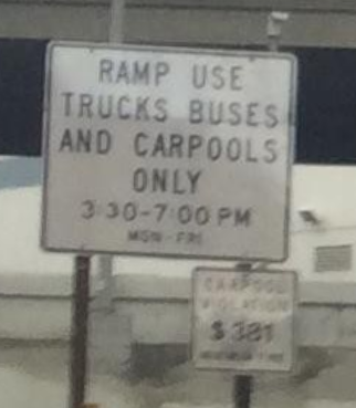
| 53630367 | about 8 years ago | its the white sign: https://user-images.githubusercontent.com/353700/32947045-064b9c6a-cbc0-11e7-8b62-c8378ccea236.png |
| 53630367 | about 8 years ago | Hi Jan, This the mapillary I used: https://www.mapillary.com/app/?pKey=5c24R-YQaeEW-39S7dOprQ&focus=photo&lat=37.783862&lng=-122.393088&z=17 From the image, it shows only HOV restriction. |
| 53209008 | about 8 years ago | You added a turn restriction on a cycle route. Curious if this is valid: relation/7677436/history Keep on mapping. |
| 51502902 | over 8 years ago | Instead of the name tag, could the fixme be used instead? |
| 50068382 | over 8 years ago | There were duplicated road segments as a result of this revert. Per OSM-US list, this is a compromise to remove the sapm. They are all fixed now: https://github.com/mapbox/mapping/issues/310 |
| 49670819 | over 8 years ago | Thanks for reply. I haven't check the data completely but a quick look seems they are all good. However, I encourage you to upload as often as possbile so that we don't have a changeset that is too big. Thanks for mapping. |
| 49670819 | over 8 years ago | Hi, PanierAvide. This edit spans the whole US. Can you point to a documentation in the wiki about this edits. On quick look this is a mechanical edit and should follow community guidelines: osm.wiki/Automated_Edits_code_of_conduct |
| 48449704 | over 8 years ago | @Streptokilla, welcome to OSM! A couple of issues Im seeing in these edits and the surrounding area: - invalid relation in landuse=forest
Some edits doesn't correspond to what I'm seeing in the imagery. Hope someone local can verify. |
| 48270769 | over 8 years ago | There are a lot on non-existing parks and ponds here. Deleted them. I also commented on your other changes on best practices. changeset/48324007 |
| 48270484 | over 8 years ago | Hi Nikos welcome to OpenStreetMap!
See changes here: changeset/48323804 |