arcth's Comments
| Changeset | When | Comment |
|---|---|---|
| 98796054 | almost 5 years ago | What was wrong with this building? |
| 97242834 | almost 5 years ago | Hello duo_lat, Most pavements in Riga are already mapped using the sidewalk tags [1], therefore it is not necessary to add separate ways for them. There is a map render [2] displaying sidewalks, cycle lanes and parking lanes mapped as part of the road. [1] sidewalk=* [2] https://osm-tiles.james-ross.co.uk/?map=18/56.957083/24.111423 |
| 94512381 | about 5 years ago | Hi, A. Čaka iela sidewalks and cycle lanes were already mapped on the way representing the street using the sidewalk [1] and cycleway [2] tags. There is a map render set up showing these [3]. [1] sidewalk=* [2] cycleway=* [3] https://osm-tiles.james-ross.co.uk/?map=18/56.950361/24.124748 |
| 94261192 | about 5 years ago | Hi, Anniņmuižas bulvāris and Zentenes iela junction was reconstructed in 2019. This changeset maps it back to the previous state due to out of date Bing imagery. |
| 86744957 | over 5 years ago | Hello mapeditor11, Most pavements in Riga are already mapped using the sidewalk tags [1], therefore it is not necessary to add separate ways for them. There is a map render [2] displaying sidewalks, cycle lanes and parking lanes mapped as part of the road. [1] sidewalk=* [2] https://osm-tiles.james-ross.co.uk/?map=18/56.957083/24.111423 |
| 82795280 | over 5 years ago | Izdzēsta detalizācija [1] bija neprecīza [2][3] un maldinoša. Muižas ēkas paliekam ir vienkārša taisnstūra kontūra [4] un caurumus jumtā/pārsegumos nevar uzskatīt par iekšpagalmiem. [1] https://www.upload.ee/image/11394915/lustes_mz.png [2] osm.wiki/Good_practice#Keep_straight_ways_straight [3] osm.wiki/Good_practice#Don.27t_map_for_the_renderer [4] https://lv.wikipedia.org/wiki/Att%C4%93ls:Lustes_pilsdrupas_2008.jpg |
| 79514401 | almost 6 years ago | Hi, currently this area is not a park. There is an abandoned velodrome overgrown with bushes. It is still disputed whether this area should be used for a park or an office building. |
| 74865974 | about 6 years ago | Hi, railway=disused [1] tag designates a railway track that visibly is not in use although is mostly intact. For a railway track that is no longer usable railway=abandoned [2] should be used. [1] railway=disused |
| 70816437 | over 6 years ago | Hi, most buildings and highways around Lamiņi were displaced by 20-30 metres to match unaligned sat images. There was quite a lot of other issues including forests and cemeteries tagged as parks, broken route relation, randomly placed tree rows, etc. I could have deleted the footway and some other features by mistake while trying to sort these out. Concerning the fence, on the sat images it is neither circular nor centred at the watertower. |
| 70642957 | over 6 years ago | Hi, to my knowledge there is no park, instead there is a schoolyard with a sports pitch surrounded by some allotments and farmland. |
| 68689833 | over 6 years ago | These buildings were demolished around year 2016. |
| 64909491 | about 7 years ago | According to the name=Kukaiņu māja tag on version 1 of this node [1], it represents an insect hotel [2] which most probably isn't an artwork. [1] http://osmhistory.appspot.com/node/6020094887/1 [2] osm.wiki/w/index.php?title=Tag:man_made%3Dinsect_hotel&oldid=1555413 |
| 51827482 | about 8 years ago | The address system in Latvia is defined by the Address Regulations[1] based on the Administrative Territories and Populated Areas law[2]. Adresses are assigned by municipal government and kept in the State Address Register[3] which is the source of addresses shown at kadastrs.lv, geolatvija.lv etc. As specified in [1], an address must have either a house name or a street and a number. Since there are no officially named streets in most hamlets of Saulkrati parish, properties there have house names consisting of a hamlet name and a number. These house names were assigned by the Saulkrasi municipality council resolution[4] on 30.06.2010, paragraphs 26--39. In the OSM wiki article on disputes there is a section[5] regarding the On the Ground Rule which suggests using an official source of names if available. Probably this also applies to addresses. [1] https://m.likumi.lv/doc.php?id=278402
|
| 51827482 | over 8 years ago | Hello HellMap, Actually, these addresses were correct. Please consider an address in Silmala[1]: the part inside quotation marks -- Silmala 223 -- is the house name. [1]: https://www.kadastrs.lv/buildings/search?cad_num=80330020789001 |
| 40146426 | over 8 years ago | Если правильно помню, на ЛЭП [406374626](way/406374626) две цепи -- 35 кВ и 110 кВ, и цепь 35 кВ заканчивается на опоре [4082344784](node/4082344784) или [4082344785](node/4082344785). |
| 24402623 | over 8 years ago | Здравствуйте! Да, в основном, исходя из некоторого представления об устройстве электросетей и опыта. |
| 45095815 | almost 9 years ago | Hi, The deleted building polygons were replaced by nodes since they were identical rectangles with rounded corners imported from a PDF map (changeset/6131373), not the actual building footprints. The wiki page Tag:building allows the building=* tag on nodes where building footprints are not yet available. Regards,
|
| 39885528 | over 9 years ago | Thanks! |
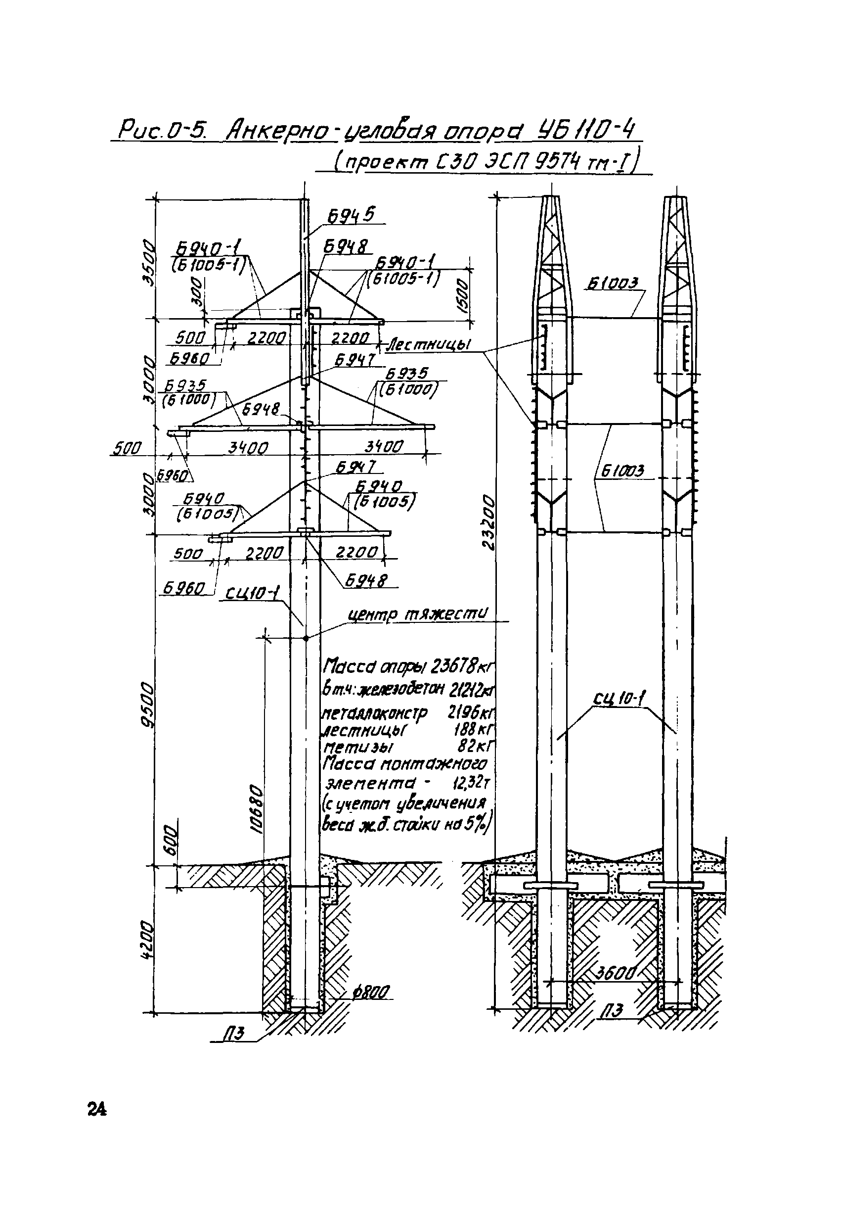
| 39885528 | over 9 years ago | Hello AkageMuk, These are towers of type УБ110-4 (catalogue 5713тм), please see the drawing[1]. The two concrete poles are fastened together making a single structure; they shouldn't be mapped separately. [1]: http://meganorm.ru/Data2/1/4293769/4293769414.files/24.gif |
| 39676815 | over 9 years ago | Hello AkageMuk, Changeset [39721601][1] should at least partially fix this. |