TomPar's Comments
| Changeset | When | Comment |
|---|---|---|
| 144878687 | about 2 years ago | Yes. However, per Concord GIS parcel maps I'm not even convinced the land is "private". |
| 143974924 | about 2 years ago | The data you deleted was mostly "highway=track". What "trails" are you referring to? Looking at recent ortho imagery, I still see tracks in the fields so your changes (deletions) are not appropriate. Please revert your changeset. Sure, some tracks are more prominent than others...and there is a threshold of what should be mapped and what doesn't qualify...but your edit seemed to be en masse. Per OSM community norms, outright deleting data is a relatively drastic step... especially if it's very obvious on imagery. Listing a reason of "...over private..." is especially triggering for reasons listed in that wiki link. Thanks. |
| 144878687 | about 2 years ago | Hello. I think you are confounding private access with private ownership. Per OSM wiki: "The access=private tag is indicating that the object is not to be used by the general public. Access is only with permission on an individual basis." I believe the general public (delivery persons for instance) does not need to request permission individually to access this road. I've noticed you've been changing quite a few access tags. Please read the wiki.
Comporting to the wiki, I think you'll find access=private is a relatively rare tag to use on private roads in this area. Thanks. |
| 143974924 | about 2 years ago | Hello. Being on private land is not a justification for removing accurate data. Why did you remove these? |
| 145040705 | about 2 years ago | Thanks. BTW, another user on the OSM Slack thought track was good here too. There are a few of us active on the Vermont and Massachusetts channels on OSM Slack. Always happy to have someone to chat about things... |
| 145040705 | about 2 years ago | I haven't been to Bolton in a couple of years but the whole thing being "service" feels a little off given I don't think it's regularly used by wheeled vehicles. The tagging history on this way has vacillated quite a bit. FWIW: I'd vote for track for most of it if not all. |
| 144974949 | about 2 years ago | Hello. Indeed. I don't see a need to duplicate the boundary if it's the same.
|
| 144509931 | about 2 years ago | I have some familiarity with the litigation of this road. My understanding is this road remains an unmaintained road by the town and therefore not a part of the "general purpose road network". If so, then highway=track is likely a better tag for the unpaved section of Estabrook Road: "The tag highway=track is used for minor land-access roads that are not considered part of the general-purpose road network" (from wiki). And to confirm: motorized vehicles are indeed allowed on Estabrook Road?(!) Thanks. |
| 144673499 | about 2 years ago | I'm incredibly appreciative of having these open natural spaces where I find such peace and benefit to my mental health. However, I think this OSM effort is one of reporting what we see on the ground and/or capturing what a critical mass of people (or the official land manager) name something. Though we're not supposed to "tag for the renderer", I think we should be mindful of how certain tags like leisure=nature_reserve get used downstream and curate appropriately. E.g. would "Panek CR" showing up in AllTrails be useful for wayfinding? I think it'd be more confusing. If the town renames this area in recognition (and publishes a map with it) then I think it'd be appropriate. The Shurtleff Woods is a bit different because it's of BCT fee ownership and there is a sign on the north end of the property. (BTW, the BCT signage and branding is really nice...the town should enlist their help! <grin>) I've only recently discovered this corner of Boxborough but it's become one of my favorite stretches of woods within 495. Thanks for the discussion. |
| 144673499 | about 2 years ago | Thanks for the additional info. It's sometimes unclear/subjective to me where the edges of the closed way that gets a "leisure=nature_reserve" should go. This seems to be one of the more important keys that third-party data users use to represent "public open space". Without immediate local knowledge, I'll look to town maps or other conservation organizations' maps to see where they draw the boundary, and to what it's called in MassGIS Open Space. (usually, these agree...sometimes not). My general rule of thumb is to combine adjacent parcels of the same fee owner if it's consistent with the "land manager's" map/Open Space. e.g. https://www.boxborough-ma.gov/351/Conservation-Trail-Maps I think there is a line where some map data goes from of use to the general public to of use to a very small number of people and thus better managed with some other tool like AGOL...but again it's a subjective thing. I think "Panek CR" falls below the threshold to get its own "leisure=nature_reserve" and clutters the map...especially because there are no on-the-ground indications of this boundary. Anyways...just wanted to share my view. Thanks for being involved with land conservation efforts. |
| 144645145 | about 2 years ago | I reverted:
|
| 144673499 | about 2 years ago | Hello. I’m curious of your reasons to add this Panek CR sub-parcel that is already contained entirely within the “Patch Hill Conservation Area”. I don’t see it referenced on other maps etc. (I had previously merged this sub-parcel to make the larger area.). Thanks. |
| 144076115 | about 2 years ago | You're welcome. I'm not a lawyer but my understanding of trespass laws in Massachusetts is for unimproved and non-enclosed land, notice must be posted: a "no trespassing" sign, etc. Regardless, this path clearly exists. So it should at least be mapped with some kind of access tagging. The wiki page I posted above succinctly captures the reasons why. I'm sensitive to private property rights and map accordingly. But again there is nothing posted. |
| 144076115 | about 2 years ago | FYI this newly created wiki page is a helpful reference for future cases like this:
|
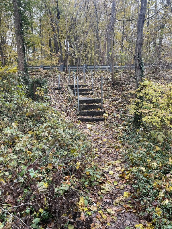
| 143089061 | about 2 years ago | There is a trail here. I just walked it today. There are even built steps down to it from Pine St.
|
| 144076115 | about 2 years ago | I walked this path today. There is a clear path. There are no "no trespassing" signs. There are no barriers. There are actually built steps, out of masonry blocks, from Pine Street to the trail. https://i.postimg.cc/50kRtPFs/IMG-8720.jpg If I didn't know about this thread, I would not have thought twice about mapping as a path on OSM. I think until the landowner puts some signage up or other indication on the ground the trail should be mapped. |
| 144076115 | about 2 years ago | The town recently acquired land just NNE and designated conservation land. See here: https://www.concordland.org/project/the-campaign-for-assabet-river-bluff/ This page, by the very well-respected local land trust, speaks of "A network of well-used neighborhood trails traverses the site and are now preserved and open to the public. The main trail along the top of the bluff affords lovely views of the river. This trail currently continues as an informal path on private property for 500 feet across four house lots and then meets the sidewalk at the Pine Street Bridge." I added the new conservation parcel and trails on it. The trails here, and on the private land are visible on lidar so people have been cutting through there for a long time. Streetview does not show "no trespassing" signs on Pine St. I hope to check out the new conservation land IRL soon. If there is nothing posted on the private land, then I believe the access tags for the path on private land should be at least "permissive". I saw the DWG ref number on the way. How does one view that? I'd like to see more information about what the landowner said. Thanks. See here too:
|
| 130768287 | about 2 years ago | Hello. This was already an "area" because it was part of a multipolygon relation. Your changes were redundant to existing geometry definitions. Please refrain from deleting boundary lines. Are you not seeing the multipolygon relations in your editor of choice? Thanks.
|
| 120761978 | about 2 years ago | I'm the one who created the original relation. Madiener, are you familiar with using multipolygons for delineating parcels? If not, please research this method. That is how this property and those adjacent were originally defined. I also noticed some other properties in MA that I had worked on were similarly broken. Please be careful. Thanks. |
| 133408244 | over 2 years ago | Thanks for the additional thoughts. And I agree, technically, with everything you said. It's not wrong per OSM norms, it's just getting to a broader OSM-based ecosystem issue as to how the data flows and is used by commercial mappers. For instance, in the popular GaiaGPS Topo layer that "track" is now displayed as prominently as other "tracks" nearby that one could drive an 18-wheeler down. The "fault" lies in the renderer. Out of the scope of OSM. It's an intractable issue the community has been grappling with forever. FWIW: this reality informs my own OSM mapping ethics. Because I know "path" or "track" will lose almost all additional tagging nuance outside of OSM, I don't tag things "track" or "path" unless it reaches a _much_ higher bar. So, it's not "wrong". It's just now the likelihood some mountain biker (or even a casual hiker) will be disappointed because the trek from Somerset Reservoir to Mount Snow is actually quite the semi-hardcore adventure involving getting bloodied legs from all the bushwhacking on the "track". |