Severak's Comments
| Post | When | Comment |
|---|---|---|
| Reporting Shortbread problems | Where to report problems with Shortbread schema itself? (Or suggestions what to add or change.) To the shortbread-docs repository? For example: while developing new style I noticed it’s not possible to differentiate subway stations and railway stations (and this is possible in OSM using subway=yes and station=subway tags). I have already noticed more of those things but I need first to sort them into different categories (bug in my style, bug in schema, bug in schema implementation etc). |
|
| Problems with level | For me it only logical thing is to use same numbering as building itself. But it seems that this is done with level:ref. |
|
| Maps Update: 17th of April | There is manual import of post boxes ongoing in Czech republic. We have dataset from the post itself. (manual import = we have source dataset from Czech Post, but each post box is manually verified and compared to existing data) |
|
| Building an inclusive map - OSM and gender discussion | Can I ask about that survey. I have problem to understand this question:
Which choice means “there is a lot of active women in community”? |
|
| Fake foreign names |
|
|
| Fake foreign names | Would be very interesting project to make map with automatic transliteration (with fallback to name:xx). I think it would be doable and quite useful. |
|
| FacilMap 2 has been released | Wow! Good job! Is there any way (aka hack) how to update data (eg markers) on collaborative map programatically? My friend was thinking about realtime radiosonde tracker. We basically have the reciever part done, so the only missing part seems to be the updater script. |
|
| Access restriction data architecture | Good point! Access tag on node is good example of thing which is easy to analyze for human and hard for computer. Human sees access node as restrictions signs in map and decides which side is restricted using the context. But this decision is one of these things which cannot by simply written as algorithm. |
|
| Experimenting with ClearTables, self-hosted vector tiles, and Tangram client-side rendering | It takes some time to render the demo. Which tool did you used to generate vector tiles? |
|
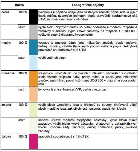
| Why copying visual style of paper maps is not a good idea | But limited color set can be also a design choice. It can help to bring some kind of systematic thinking to the map key. For example, Czech military map used 9 colors only. Unlike on OSM base map here I can identify features at the first glance without looking to legend.
(my shameless copy of czech military map styling, not the original military map itself)
(colors explanation table) |
|
| How to actually invent tags | yes, tags can be very confusing. My favorite confusion is |