
Koreller
- Mapper since:
- January 01, 2021
- Last map edit:
- June 20, 2026
About me
My nickname is Koreller, I’m a french contributor, I was born in 1995 and I live in Nantes. I am registered in OSM since January 1st 2021 and I started to contribute since July 2021.
Besides, I am a contributor to the Wikimedia projects (Wikipedia, Wikisource, Wikidata and Commons) since 2015.
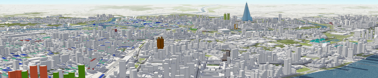
See my diaries if you’re interested in a complete thematic guide, skyscrapers, how to map a capital city, JOSM tricks, or even 3D OSM at a glimpse!
Contribution
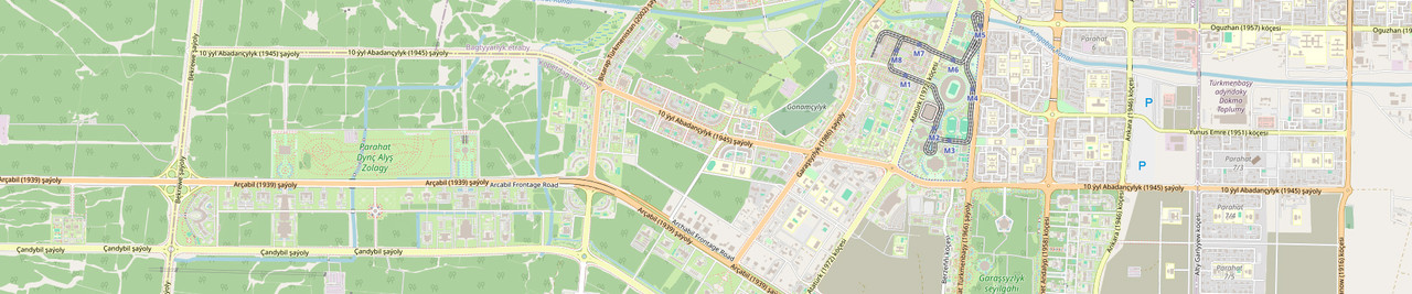
I’m mainly focusing on mapping North Korea, for which I created a contribution guide on the wiki North Korea Mapping Guide, the french language version is the most up-to-date, and especially in Pyongyang. Early 2024, I began work on Ashgabat.
I also make some minor corrections in my department, but because it’s already well mapped, I prefer to map other areas.
Why am I mapping?
Mainly for the beauty of the maps, I love making and seeing beautiful maps full of detail and feeling the work behind the maps.
Secondly, on OpenStreetMap (as on Wikipedia in French) I like to do areas (or subjects) where I feel the added value is maximum: on OpenStreetMap mapping cities where almost no other detailed web map exists or is easily accessible, on Wikipedia in French it’s subjects for which Wikipedia in English has no article, that’s what I prefer!
My work on North Korea comes from the fact that it is unfortunately rare to have complete sources on any aspect of North Korea, and maps are a way of having something complete on certain themes. This data can be used by a whole range of actors, whether they be scientists, humanitarian aid workers, international organizations or the simply curious.
I’m particularly interested in the cities of totalitarian countries (aka Pyongyang, and now Ashgabat), because the diversity of things to map is great, they’re quite mysterious and secret!
Work in progress
- Mapping of Pidan Island (North Korea)
- Mapping and micromapping in Ashgabat (Turkmenistan)
- Mapping various islands in North Korea
Past work
- Mapping of various settlements (North Korea)
- Mapping of Kowon (North Korea)
- Mapping of Kumya (North Korea)
- Micromapping of the ASBL based on Vertou (France)
- Mapping of Yonan, Kumgok-ri (North Korea)
- Mapping of west side of Nampo (North Korea)
- Mapping of Ochum (Cambodia)
- Mapping of Kaesong (North Korea)
- Mapping of Chongsan-ri Cooperative Farm between Pyongyang and Nampo (North Korea)
- Mapping of Tudan-do (North Korea)
- Mapping of Sepo (North Korea)
- Mapping of Sinchon (North Korea)
- Mapping of Rajin (North Korea)
- Mapping of Oranjemund (Namibia)
- Mapping of Onsong and around (North Korea)
- Mapping of Cohiniac (France)
- Mapping of Sinchon (North Korea)
- Mapping of Samjiyon (North Korea)
- Mapping of Kon Plong (Vietnam)
- Mapping of Minburn (USA)
- Mapping of Anak County (North Korea)
- Adding addresses of Pont-Saint-Martin (France)
- Adding addresses of Bouée (France)
- Adding addresses of Cheix-en-Retz (France)
- Mapping of Carré M in Montévrain (France)
- Indoor mapping of Shopping Center Auchan Sillon de Bretagne (France)
- Indoor mapping of Shopping Center Carrefour Saint-Herblain (France)
- Indoor mapping of Shopping Center E.Leclerc Orvault Grand-Val (France)
- Mapping of center of Chaeryong County (North Korea)
- Mapping of Chodo (North Korea)
- Mapping of Hoechang (North Korea)
3D
- 3D in Pyongyang : Chilgol Church ; Changchung Cathedral ; Pyongyang Sci-Tech Complex ; Church of the Life-Giving Trinity ; Liberation Tower ; Monument Party Founding ; Pyongyang Station ; Bongsu Church ; Pyongyang TV Tower ; Sino-Korean Friendship Tower ; Pyongyang International Cinema House ; Mangyongdae Children’s Palace ; United Front Monument ; Pyongyang Ice Rink ; International Cultural Center ; Juche Tower ; Koryo Hotel ; Yanggakdo Hotel ; People’s Army Circus ; Ryugyong Hotel ; Ryanggang Hotel ; Sosan Hotel ; Chongnyon Hotel ; Pyongyang Circus ; Pyongyang Arena ; KWP Scientists Apartment ; Pyongyang Informatic Centre Hotel ; Chongnyu Restaurant ; Pontongmun ; Pyongyang Gymnasium ;
- 3D in Ashgabat : Arch of Neutrality ; Constitution Monument ; Independence Monument ; Altyn Asyr Shopping Centre ; Yyldyz Hotel ; Central Bank ; National Bank ; Hazret Omar Mosque ;
- 3D Église Sainte Thérèse in Nantes (France)
- 3D Diplomat Hotel in Baguio (Philippines)
- 3D Melvine Monument in Edinburgh (Scotland)
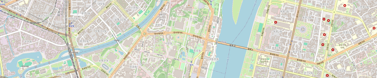
PYONGYANG
- Mapping of the area of Turu et Ssuk Island (North Korea)
- Mapping of the area of Yangak Island (North Korea)
- Mapping of Kwangbok Street (North Korea) and in 3D
- Mapping of Tungil Street (North Korea) and in 3D
Koreller loves OpenStreetMap <3
⠀⠀⠀⠀⠀⠀⠀⠀⠀⠀⠀⠀⠀⠀⢀⣀⣄⣠⣀⡀⣀⣠⣤⣤⣤⣀⠀⠀⠀⠀⠀⠀⠀⠀⠀⠀⠀⠀⠀⠀⠀⠀⠀⠀⠀⠀⠀⠀⠀⠀⠀⠀⠀⠀⠀⠀⠀⠀⠀⠀⠀⠀⠀ ⠀⠀⠀⠀⠀⠀⠀⠀⠀⠀⣄⢠⣠⣼⣿⣿⣿⣟⣿⣿⣿⣿⣿⣿⣿⣿⡿⠋⠀⠀⠀⢠⣤⣦⡄⠀⠀⠀⠀⠀⠀⠀⠀⠀⠀⠰⢦⣄⠀⠀⠀⠀⠀⠀⠀⠀⠀⠀⠀⠀⠀⠀⠀ ⠀⠀⠀⠀⠀⠀⠀⠀⣼⣿⣟⣾⣿⣽⣿⣿⣅⠈⠉⠻⣿⣿⣿⣿⣿⡿⠇⠀⠀⠀⠀⠀⠉⠀⠀⠀⠀⠀⢀⡶⠒⢉⡀⢠⣤⣶⣶⣿⣷⣆⣀⡀⠀⢲⣖⠒⠀⠀⠀⠀⠀⠀⠀ ⢀⣤⣾⣶⣦⣤⣤⣶⣿⣿⣿⣿⣿⣿⣽⡿⠻⣷⣀⠀⢻⣿⣿⣿⡿⠟⠀⠀⠀⠀⠀⠀⣤⣶⣶⣤⣀⣀⣬⣷⣦⣿⣿⣿⣿⣿⣿⣿⣿⣿⣿⣿⣿⣿⣿⣿⣶⣦⣤⣦⣼⣀⠀ ⠈⣿⣿⣿⣿⣿⣿⣿⣿⣿⣿⣿⣿⡿⠛⠓⣿⣿⠟⠁⠘⣿⡟⠁⠀⠘⠛⠁⠀⠀⢠⣾⣿⢿⣿⣿⣿⣿⣿⣿⣿⣿⣿⣿⣿⣿⣿⣿⣿⣿⣿⣿⣿⣿⣿⣿⣿⣿⣿⡿⠏⠙⠁ ⠀⠸⠟⠋⠀⠈⠙⣿⣿⣿⣿⣿⣿⣷⣦⡄⣿⣿⣿⣆⠀⠀⠀⠀⠀⠀⠀⠀⣼⣆⢘⣿⣯⣼⣿⣿⣿⣿⣿⣿⣿⣿⣿⣿⣿⣿⣿⣿⣿⣿⣿⣿⣿⣿⡉⠉⢱⡿⠀⠀⠀⠀⠀ ⠀⠀⠀⠀⠀⠀⠀⠘⣿⣿⣿⣿⣿⣿⣿⣿⣿⣿⣟⡿⠦⠀⠀⠀⠀⠀⠀⠀⠙⣿⣿⣿⣿⣿⣿⣿⣿⣿⣿⣿⣿⣿⣿⣿⣿⣿⣿⣿⣿⣿⣿⣿⣿⡿⡗⠀⠈⠀⠀⠀⠀⠀⠀ ⠀⠀⠀⠀⠀⠀⠀⠀⢻⣿⣿⣿⣿⣿⣿⣿⣿⠋⠁⠀⠀⠀⠀⠀⠀⠀⠀⠀⢿⣿⣉⣿⡿⢿⢷⣾⣾⣿⣞⣿⣿⣿⣿⣿⣿⣿⣿⣿⣿⣿⣿⣿⠋⣠⠟⠀⠀⠀⠀⠀⠀⠀⠀ ⠀⠀⠀⠀⠀⠀⠀⠀⠀⠹⣿⣿⣿⠿⠿⣿⠁⠀⠀⠀⠀⠀⠀⠀⠀⠀⠀⣀⣾⣿⣿⣷⣦⣶⣦⣼⣿⣿⣿⣿⣿⣿⣿⣿⣿⣿⣿⣿⣿⣿⣷⠈⠛⠁⠀⠀⠀⠀⠀⠀⠀⠀⠀ ⠀⠀⠀⠀⠀⠀⠀⠀⠀⠀⠉⠻⣿⣤⡖⠛⠶⠤⡀⠀⠀⠀⠀⠀⠀⠀⢰⣿⣿⣿⣿⣿⣿⣿⣿⣿⣿⣿⣿⡿⠁⠙⣿⣿⠿⢻⣿⣿⡿⠋⢩⠀⠀⠀⠀⠀⠀⠀⠀⠀⠀⠀⠀ ⠀⠀⠀⠀⠀⠀⠀⠀⠀⠀⠀⠀⠀⠈⠙⠧⣤⣦⣤⣄⡀⠀⠀⠀⠀⠀⠘⢿⣿⣿⣿⣿⣿⣿⣿⣿⣿⣿⡇⠀⠀⠀⠘⣧⠀⠈⣹⡻⠇⢀⣿⡆⠀⠀⠀⠀⠀⠀⠀⠀⠀⠀⠀ ⠀⠀⠀⠀⠀⠀⠀⠀⠀⠀⠀⠀⠀⠀⠀⢠⣿⣿⣿⣿⣿⣤⣀⡀⠀⠀⠀⠀⠀⠀⠈⢽⣿⣿⣿⣿⣿⠋⠀⠀⠀⠀⠀⠀⠀⠀⠹⣷⣴⣿⣷⢲⣦⣤⡀⢀⡀⠀⠀⠀⠀⠀⠀ ⠀⠀⠀⠀⠀⠀⠀⠀⠀⠀⠀⠀⠀⠀⠀⠈⢿⣿⣿⣿⣿⣿⣿⠟⠀⠀⠀⠀⠀⠀⠀⢸⣿⣿⣿⣿⣷⢀⡄⠀⠀⠀⠀⠀⠀⠀⠀⠈⠉⠂⠛⣆⣤⡜⣟⠋⠙⠂⠀⠀⠀⠀⠀ ⠀⠀⠀⠀⠀⠀⠀⠀⠀⠀⠀⠀⠀⠀⠀⠀⠀⢹⣿⣿⣿⣿⠟⠀⠀⠀⠀⠀⠀⠀⠀⠘⣿⣿⣿⣿⠉⣿⠃⠀⠀⠀⠀⠀⠀⠀⠀⠀⠀⣤⣾⣿⣿⣿⣿⣆⠀⠰⠄⠀⠉⠀⠀ ⠀⠀⠀⠀⠀⠀⠀⠀⠀⠀⠀⠀⠀⠀⠀⠀⠀⣸⣿⣿⡿⠃⠀⠀⠀⠀⠀⠀⠀⠀⠀⠀⢹⣿⡿⠃⠀⠀⠀⠀⠀⠀⠀⠀⠀⠀⠀⠀⠀⢻⣿⠿⠿⣿⣿⣿⠇⠀⠀⢀⠀⠀⠀ ⠀⠀⠀⠀⠀⠀⠀⠀⠀⠀⠀⠀⠀⠀⠀⠀⢀⣿⡿⠛⠀⠀⠀⠀⠀⠀⠀⠀⠀⠀⠀⠀⠀⠀⠀⠀⠀⠀⠀⠀⠀⠀⠀⠀⠀⠀⠀⠀⠀⠀⠀⠀⠀⠘⢻⡇⠀⠀⢀⣼⠿⠇⠀ ⠀⠀⠀⠀⠀⠀⠀⠀⠀⠀⠀⠀⠀⠀⠀⠀⢸⣿⠃⣀⠀⠀⠀⠀⠀⠀⠀⠀⠀⠀⠀⠀⠀⠀⠀⠀⠀⠀⠀⠀⠀⠀⠀⠀⠀⠀⠀⠀⠀⠀⠀⠀⠀⠀⠀⠀⠀⠀⠙⠁⠀⠀⠀
“Keep OSM weird and fun”
Latest Diaries
Diary Entry Drawing shapes in JOSM, little-known shortcuts
I really love JOSM, and the more I use it, the more I discover that it offers some very useful features… that some of you may not be aware of ! Eve...
Diary Entry Cho-do, modern and ancient mapping of a North Korean island
Sometimes some maps are more satisfying than others. What I did on “Cho-do” (“초도”) — Cho island — is definitely one of them! Cho-do in North Korea...
Diary Entry Better OSM Diary : ideas, reflexions, improvements
I see many diaries on OSM, but unfortunately the good ones are hard to find, if they can be found at all. In this diary, I offer some perspectives...
Diary Entry Building drawing tips, a perfect guide
In this diary, I’m going to explain how I draw buildings (and shape in general), with my tricks for doing the most precise work possible and achiev...