Howpper's Comments
| Changeset | When | Comment |
|---|---|---|
| 61753144 | Noyes, mn |
|
| 61484899 | The most likely reason for the lack of info on it is the fact that it was decommissioned before the state highway renumbering in 1964. |
|
| 61422254 | Sorry for the late response. I removed some old stream beds that were filled in. |
|
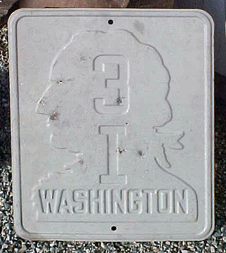
| 61484899 | I am 100% certain it was 3I. It took it's name from Primary State Highway 3. There were 22 primary state highways, so it couldn't have been 31. Secondary state highways always had letters and took their number from their parent route. Here is a shield of it: https://www.aaroads.com/shields/img/WA/WA19380031i1.jpg |
|
| 61622278 | Sorry for taking so long to respond. http://www.historicmapworks.com/Map/US/1313215/Page+026+++Township+52+N++Range+3+W+++Chilco++Hayden+Lake++Cedar+Mtn/Kootenai+County+1959/Idaho/ |
|
| 61736243 | Apparently North of 8th/Hartson Havana functions as the eastern city line of Spokane. The east half of Havana is outside both cities, and the eastern edge of the road is the Spokane Valley City Line. |
|
| 61735406 | At least, that was the proper spelling even then. |
|
| 61735406 | French fur traders spelled it "Cœur d'Alêne" |
|
| 61697238 | Thank you for pointing that out, I have now fixed it. |
|
| 61699813 | Around WA 224 / WA 240 Junction. |
|
| 61696941 | (Pryor) |
|
| 61666133 | Please us ESRI world imagery in Spokane area and Mapbox imagery for Coeur d'Alene area. |
|
| 61674749 | French spelling* |
|
| 61673204 | (Havana north of 8th). |
|
| 61644634 | Nevermind, upon further review I agree with your original statement. |
|
| 61644634 | Are you sure the Horse Heaven airstrip should be described as abandoned? People still land there more than occasionally. |
|
| 61643895 | Corrected road geometry* |
|
| 61603192 | SH 41* |
|
| 61495023 | Changed from "Cheney Spokane Road" to "Cheney-Spokane Road" |
|
| 61489243 | (Appleway/Argonne/Mullan/Dishman-Mica intersection) |