AustinAkaHadiRender
- Mapper since:
- March 07, 2021
- Last map edit:
- January 15, 2026
🌍✨ Mapping Syria, One Image at a Time
🛰️ A Mission to Rebuild Digital Geography
Hello! 👋 I’m Austin aka Hadi, and I’m on a mission to visually rebuild and fix Syria’s maps through on-the-ground contributions — capturing streets, villages, borders, roads, signs, and hidden paths that no map has ever seen before.
📸 Why I Do This
Syria has thousands of places with missing, outdated, or incorrect map data.
I decided to be the change — by mapping:
- 🛣️ Roads that don’t exist on any app
- 🏘️ Villages that were never documented
- 🚧 New construction and demolished areas
- 🆘 Critical areas for humanitarian aid
🇸🇾 Syria Image Gallery
Image 1
Freedom and hope in every corner of Syria!
Image 2
Capturing roads and hidden paths for safer navigation.
Image 3

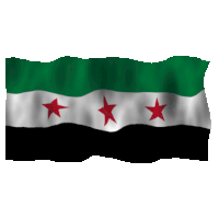
Symbols of pride and identity, preserved digitally.
Image 4
Small villages and corners of Syria that need recognition.
Image 5
Dynamic visual storytelling of Syria’s landscapes.
Image 6
![]()
By Kamil Nikel - mapillary.com, Public Domain, Link
🏞️ Benefits of Mapping Syria
By contributing images and mapping data, I help create a complete digital ecosystem:
- 🚑 Emergency response & navigation – First responders can find routes faster
- 📦 Delivery & services – Businesses and aid organizations can operate efficiently
- 🚗 Driver routing & GPS accuracy – Reduces accidents and confusion
- 🌐 Online platform accuracy – Map services like Google Maps, Mapillary, and OpenStreetMap improve
- 🏠 Humanitarian planning – Relief teams know exactly where to go
- 📡 Future smart services – Drones, IoT, and GPS tracking will work more effectively
🚀 How I Contribute
I use platforms like Mapillary, OpenStreetMap, GPS tools, and open imagery to provide Syria with the coverage it deserves.
I contribute by:
- 📱 Uploading thousands of street-level images
- 🗺️ Correcting broken or outdated maps
- 🧭 Adding missing roads, paths, and intersections
- 🚦 Marking signs, crossings, and obstacles
- 🏗️ Documenting construction and demolition changes
- 🏘️ Capturing villages no one has mapped before
🔧 Tools I Use
| Tool | Purpose |
|---|---|
| 📱 Action Cameras | Capture stable, high-quality images |
| 🚴 Bike / Walking Routes | Detailed mapping on-the-go |
| 🛰️ GPS Tracking | Exact road geometry and coordinates |
| ☁️ Open Platforms | Helps correct errors and verify data |
🌱 Join Me
Whether you’re a Syrian, mapper, traveler, or curious learner, you can contribute too! Every image, every correction, every note builds a better, safer, smarter Syria.
🌍 Let’s illuminate Syria together — road by road, street by street, image by image.
✨ Mapping isn’t just about geography — it’s about giving back visibility, safety, and opportunity to every corner of Syria!

☕ Support Me on Ko-fi