Arminus's Comments
| Changeset | When | Comment |
|---|---|---|
| 152110280 | over 1 year ago | "great advantage of specifying the difficulties in each section" => of course, and I didn't remove the scales on any way What I did was add a scale to the entire ferrata relation. This could theoretically be calculated by picking the highest difficulty of all its ways, but in reality, this might not always be correct, hence the tag. |
| 152110280 | over 1 year ago | "find a top" -> find on a topo |
| 152110280 | over 1 year ago | I agree on your last comment, nevertheless, every ferrate as a whole typically has an overall scale. In other words, tags on individual ways classify the "sub scales" (which you typically find a top), while the scale on the entire ferrata classifies the ferrata in its entirety. This is also common practice for other relations like cross country tracks for example. Anyway, I would kindly invite you to add to the discussion in the referenced wiki-page, this "discussion" here will eventually get lost. |
| 152110280 | over 1 year ago | Sorry, I forgot the comment on the change record, please see osm.wiki/Proposal:Via_ferrata#Tagging_as_route=via_ferrata_relation - the via_ferrata_scale tag on relations is used since many years |
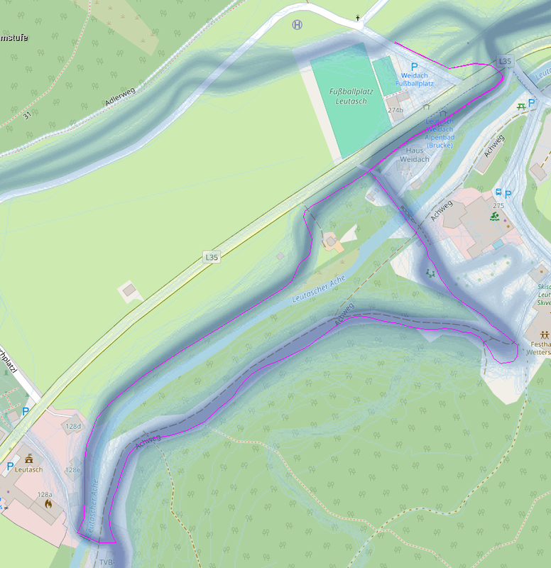
| 146410321 | almost 2 years ago | Hier noch die Strava Heatmap: https://i.postimg.cc/3xk8CmR8/Snowfarmingloipe-Leutasch.png ich hab die Relation eben wieder angelegt: changeset/146713727 |
| 146410321 | almost 2 years ago | Hier wurde u.a. die relation/17016957 gelöscht, diese Loipe gibt es aber: https://www.seefeld.com/de/touren/snowfarmingloipe-leutasch.html |
| 145662775 | almost 2 years ago |
Leider auch 2023 keine Einigung |
| 142193689 | about 2 years ago | Geht mit dem JOSM reverter plugin ganz einfach -> changeset/142294198 Hab die trail visibility mal auf intermediate gesetzt, schau mir das definitiv noch vor dem Winter vor Ort an. |
| 142193689 | about 2 years ago | Gestern war wieder jemand beim GC71GVK - Zitat: "sowohl der Zuweg vom Parkplatz am Forstweg als auch der Rückweg über den Fußweg sind problemlos möglich." Ich denke den delete hier sollte man wirklich reverten... |
| 142193689 | about 2 years ago | Ich schau mir das die Tage mal vor Ort an. |
| 142193689 | about 2 years ago | Bist Du Dir sicher dass der komplette Weg zugewachsen ist? Laut log im GC71GVK war hier jemand am 17.09. ohne Probleme von oben unterwegs, m.E. ist der Weg nur von unten/Norden zugewachsen. |
| 128428031 | about 2 years ago | To which way/part do you think the name applies? I used sources as mentioned in the changesets source info, unfortunately, I have no local expertise... |
| 128913330 | about 3 years ago | Der Vollständigkeit halber: Siehe auch osm.wiki/w/index.php?title=DE_talk:Tag:place%3Dtown&action=history Dort hat bisher keine Diskussion stattgefunden, lediglich ein Braindump (s)einer Meinung. |
| 114621369 | about 3 years ago | Fun fact: Inzwischen hat jemand eine alte Karte im Bayernatlas ausgegraben in der der Bockstein 1808-1864 tatsächlich am Breitenstein Westgipfel verortet wird: https://geoportal.bayern.de/bayernatlas/?lang=de&topic=ba&bgLayer=historisch&E=723690.89&N=5289603.80&zoom=15&catalogNodes=11 |
| 126637551 | about 3 years ago | naja, wenn ich mir die history hier ansehe, außer good und excellent hatte der way in den letzten 2 Jahren Alles, das sagt schon viel aus... Und nein, für löschen bin ich nicht, dann wir er spätestens nächstes Frühjahr von unten her wieder gemappt. Aber Dein "aufgegeben und wird nicht mehr unterhalten" deutet m.e. klar auf osm.wiki/DE:Key:abandoned:* |
| 126637551 | about 3 years ago | Am Gipfel splitten und den Weg im Wald auf abandoned? |
| 124392676 | over 3 years ago | |
| 124392676 | over 3 years ago | Siehe note note/3295859 - da hat anonymous m.E. Recht, Funk ist hier kein Straßennahme |
| 123515543 | over 3 years ago | Ja, weil er halt auf ~ 25km komplett doppelt gemappt auf bereits vorhandenen Wegen verlief. Aber Thema erledigt, siehe relation/14370364 |
| 123184088 | over 3 years ago | Weiter bitte ggf. bei changeset/123834215 - der weitere Verlauf Grenze->Thiersee ist mir noch nicht klar |