Changeset: 90871685
The "geographic region of Italy" is at best an ill-defined historic boundary (which we don't map), and at worst a right-wing political fantasy. I am removing this with my DWG hat on. Do not undelete without a thorough discussion on talk-it *first*.
Closed by woodpeck
Tags
| bot | yes |
|---|---|
| created_by | osmtools/30252 (linux) |
Discussion
-
Comment from totera
Hi Frederik, I think you have been badly informed about Italian geographical region, while a Wikipedia search could have been enough: it is the name commonly found in textbooks, encyclopedias, etc to refer to the land south of the Alpine watershed, which does not fully correspond with the borders of Italy.
It is not an historic border (a sovereign entity exactly corresponding with Italian geographical region has never existed), least of all a "right-wing political fantasy". In the past irredentist movements that promoted the annexation of neighbouring regions to Italy have existed, but their claims were on ethnic and linguistic basis rather than geographic.
After all, in Openstreetmap you can find the Iberian Peninsula relation (https://www.openstreetmap.org/relation/3870917), which I don't think you would define a pan-Iberist political fantasy...I'm going to start the discussion on talk-it. Anyway, this relation was already discussed in 2017 (https://lists.openstreetmap.org/pipermail/talk-it/2017-October/060515.html), with users almost equally split between approving and opposing this relation.
-
Comment from sabas88
Hi Frederink, it needs only Wikipedia to check if accurate https://en.wikipedia.org/wiki/Italian_geographical_region
Perhaps someone should translate it on dewiki as well but I don't know german....
-
Comment from woodpeck
The fact that a Wikipedia entry exists for something does not mean that the thing itself exists!
-
Comment from woodpeck
https://en.wikipedia.org/wiki/Greater_Germanic_Reich <-- we wouldn't want to map that either
-
Comment from sabas88
Godwin's Law at the first repty? Wow
That's a "political entity" (Q51335349 on wikidata) not a "geographical region" (Q82794 on wikidata)
-
Comment from dieterdreist
I agree with the deletion. Replying to @totera you wrote: "In the past irredentist movements that promoted the annexation of neighbouring regions to Italy have existed, but their claims were on ethnic and linguistic basis rather than geographic." -- claiming "italian geographical region" is not about physical "geography", it is about the cultural geography of humans (language, culture etc.), there is no other meaning in "italian" or "italic" than a cultural one.
-
Comment from lorec10
Hi, I’m the original author of the relation, the “geographic region of Italy” is neither "an ill-defined historic boundary", neither "a right-wing political fantasy”, it is defined as the territory south of the main alpine drainage divide on the European continent plus all the island geographically belonging to Europe, off the coasts of Italy.
what is talk-it, how do I take part in the discussion? -
Comment from dieterdreist
lorec, if you go by coast proximity, shouldn't the Sardegna be part of Tunisia then? Was Malta contained? What about Palagruža?
-
Comment from dieterdreist
talk-it is a mailing list for Italy.
https://lists.openstreetmap.org/listinfo/talk-it -
Comment from lorec10
The island of Sardinia, the archipelago of Malta and the islands of Pelagosa are all part of the European continent and the closest European continental coasts to all those islands belong to the geographical region of Italy.
-
Comment from dieterdreist
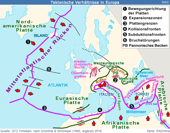
if we agree on plate tectonics for determining the belonging, the eastern parts of Italy and significant parts of the po valley are geographically in Africa:
http://www.raon.ch/images/edu/haz3/eu_Bruchzonen16001.gif - Comment from dieterdreist
-
Comment from lorec10
on a geological basis yes, not on a geographical basis: https://en.wikipedia.org/wiki/Europe
-
Comment from Fintocubano
I would not deem the concept of *Geographic Region of Italy* as an 'ill-defined historic boundary'. I guess we need to look at three different kinds of definitions of *Geographic Region of Italy* to avoid confusion.
The first definition - geological - is the one mapped in OSM: the orange boundary I can see loosely coincides with the Italian geological region as defined by pre-eminent geologists, which include portion of Tunisia as fas as the Dinaric Alps (1),(2).
The second definition - physical - has been proposed, with slight differences, by several authors and publications in the past, like the De Agostini Encyclopaedia for one, and is equivalent to the *Physical Region of Italy* featuring the Alps as its natural boundary to the north, east and west and, therefore, including part of the Tessin Canton (Switzerland), San Marino and the Holy See, Istria in Croatia, Corsica and the Tenda/Roia valley in France.
The third definition - political - has varied quite widely through the centuries since the Greeks founded their colonies in the current regions of Sicily, Calabria and part of Apulia (4) all through the Roman Empire until after the Fascist era, when Italy took the current geographical boundary by losing portions of its Italian-speaking territories (notably Istria and part of Dalmazia and Venezia-Giulia)
I agree I would not rely on Wikipedia as a source of 100% trusted, factual and accurate information. I would rather check what printed sources and scholars say on the matter.
That said, the key question I think is: does OSM allow mapping of geological and physical boundaries or *just* political boundaries are allowed?
--
Notes
(1) Enciclopedia Treccani, https://images.treccani.it/enc/media/share/images/orig/system/galleries/Carte_Geopolitico/ITALIA2.jpg from the hypertext 'Regione Italiana', Section 1.1 at the URL https://www.treccani.it/enciclopedia/italia/.
(2) J. Aubouin, R. Brousse, Compendio di Geologia-volume 2, CEA, Milano, 1977. See index at the URL: http://www5.unitn.it/Biblioteca/it/Web/EngibankFile/Compendio%20di%20geologia%20vol.2.pdf
(4) Enciclopedia Treccani, ibidem, Section 6: ''La nozione geografica di Italia, nella più antica tradizione classica, è sottoposta a oscillazioni. Alla fine del 6° sec. a.C., era la regione nella quale i Greci avevano fondato molte colonie costiere, sullo Ionio e sul Tirreno'' -
Comment from sabas88
@lorec10 se vuoi iscriverti alla mailing list ma non sai come fare / non ne hai voglia (lo capisco :D) scrivimi pure un messaggio diretto, sono l'amministratore della lista
@dieterdreist perché dobbiamo ridefinire cose per le quali ci sono esperti di settore?
@all I suggest to make a RfC and a voting round to settle this
-
Comment from lorec10
It does allow geographical/physical relations: https://www.openstreetmap.org/relation/3870917
-
Comment from lorec10
mi sono iscritto ma non ho capito come si fa a rispondere al thread
-
Comment from dieterdreist
@sabas88 a cosa ti riferisci?
-
Comment from woodpeck
I have removed the region again in https://www.openstreetmap.org/changeset/92722694 and will issue account blocks for anyone who reinstates it without first achieving a consensus on talk-it that it is a thing that should be mapped. DWG Ticket#2020101910000354
Ways (17)
813498427, v6813501521, v7503358796, v5813957746, v2813954760, v6813505885, v6813475591, v8813496747, v4813951673, v6843995480, v2813483798, v6813951672, v6503338187, v9813501520, v10503338189, v8813938747, v8813481263, v8
Relations (1)
Welcome to OpenStreetMap!
OpenStreetMap is a map of the world, created by people like you and free to use under an open license.
Hosting is supported by Fastly, OSMF corporate members, and other partners.
| https://openstreetmap.org/copyright | https://openstreetmap.org |
| Copyright OpenStreetMap and contributors, under an open license | |