Changeset: 88211516
Attempt to fix coastline (correctly this time), by restoring natural=coastline to the Rio de la Plata. A change of this size breaks coastline rendering updates across the world. If you want to discuss it, make a formal proposal.
Closed by JesseFTW
Tags
| created_by | JOSM/1.5 (16731 en) |
|---|---|
| review_requested | yes |
| source | OpenStreetMap Carto (Standard); JOSM Validator |
Discussion
-
Comment from christiank61
Good luck!, The Mapper that made this bay (coastline) to a waterway always revert. Jochen Topf stopped making Land_Shapes cause of this silly tagging.......
-
Comment from muralito
This is not an attepmt to fix coastline, as the coastline was not broken.
Rio de la Plats is not ocean, and it is not coastline.
Please stop tagging like this, and don't map for the renderer. -
Comment from JesseFTW
The updates to the coastline have not been updated for six months. That's what I'm trying to fix. I have no opinion on this particular change -- but it's so large that it triggers an automatic circuit breaker. Once we've gotten the updates to go thru, please DO revert Rio de la Plata back to being marked as not-coastline -- just do so in small enough chunks that it doesn't trigger the circuit breaker. I'm happy to work with you to help do that.
-
Comment from muralito
OK, I do not know why replacing a simple coastline of two ways by a complex polygon (~700) of small lines can help you, and what have this to do with updates to the coastline not being done.
Please explain what you mean to do it in small chunks, as If the coastline change is not done in one single changeset atomically, the coastline would be broken until all tne small chunks where uploaded.
-
Comment from JesseFTW
Sure -- it's a strange and frankly kinda silly reason, so I don't blame you at all for being confused by it!
The rendering of the coastline on openstreetmap.org is based on data produced by osmdata.openstreetmap.de, daily. As part of that process, the script that does it checks to see how much the coastline (across the world) changed since the previous valid day (normally the previous day, but, right now, all the way back to Jan 9, 2020). If the difference is more than 0.0000015 (as shown here: https://github.com/fossgis/osmdata/blob/master/scripts/coastline/compare-coastline-polygons.sh#L13 ), it automatically rejects it.
And changing the Rio de la Plata to be correctly marked as not an ocean is way bigger than that. So in order to avoid this automatic block, we need to change small sections, one each day. Or we need to make a formal proposal (probably on the wiki), get explicit buy-in from a bunch of local mappers, then go to the maintainer of the script and ask for a manual override.
Either way is fine with me -- but just making the change all at once merely causes the rest of the world to not get any coastline updates, which is bad for everyone.
Hope that explains things more -- I'm glad to clarify further if it doesn't!
-
Comment from christiank61
To say it clear: Mapping this large Bay as river is, well....
It's salt water in this bay so its the Ocean - Period. Its not amusing that some mappers make their own rules and the only argument is "we do not map for the renderer". Its not amusing that the OSM authoritys leadership is to weak to stop this. -
Comment from muralito
No, you are completly wrong. It not salt water, and no tidal, only microtidals and some days every year meteorological when the wind stop the water flowing to the ocean.
-
Comment from muralito
And the data was rigth, so its the script and their choices what should be fixed.
-
Comment from muralito
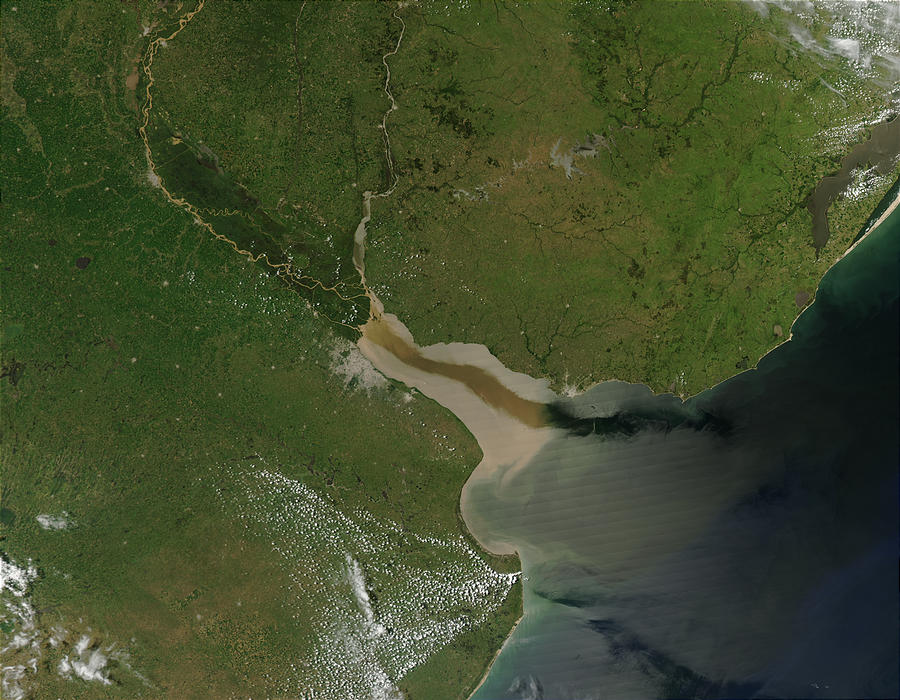
Some people just do not understand that not all places in the world are the same and keep insisting in applying their local knowledge and experience where it is not valid anymore. Rio de la Plata has a discharge of 26 000 m³/s, orders of magnitude grater than rivers in Europe, so i know that is difficult for some people to understand the differences when they are used to other facts.
-
Comment from muralito
a one-time change to the maximum script limit, coordinated with the atomic change of the coastline, it's what seems better, in terms of less work, and less prone to errors than progressively making many changes to the coastline in small stretches, each they can introduce errors without detecting them.
-
Comment from christiank61
@muralito:
See here the aerial image from the delta:
https://de.wikipedia.org/wiki/R%C3%ADo_de_la_Plata#/media/Datei:Rio_de_la_Plata_BA_2.JPG
If you enlarge the river mouth its extreme extend is the line of Montevideo and not the outer Ocean (Maldonado). -
Comment from muralito
The coastline was in the limit of the river with the ocean for years. Some months ago some user altered it and i restored it. But the difference that broke the script shouldn't be here.
-
Comment from christiank61
In addition: there is a noticable Tide - even at Buenos Aires:
https://www.tide-forecast.com/locations/Buenos-Aires-Argentina/tides/latest
Dont get me wrong - I can't judge/decide what to do with this issue. However: IMO Tidal means Ocean, means Coastline.
regards, Christian, OAM -
Comment from muralito
First of all these aereial image are artifically coloured, doesnt it? In addition, this photo clearly shows how far fresh water reaches, which even exceeds the Punta del Este-Punta Rasa limit. https://upload.wikimedia.org/wikipedia/commons/c/cf/River_Plate.jpg
A image is just a image, but the image is clear, and it agrees with the scientific studies that demonstrate it,Second, the limit of the river with the ocean, where the salinity changes is in Punta del Este and Punta Rasa., which is accepted decades ago by the IHO. The
Third, as I mentioned before, the tides are micro tides, at most half a meter. the determining factor of the tidal height in the Rio de la Plata is the meteorological one, that is, the direction from which the wind blows. When the wind helps drain the river, you can see the water go away even 100 or 200 meters, the ports are dry with sailboats stranded. When the wind stops the flow of the river, the level of the river rises several meters, that the beaches are not almost visible, but it is not like in other parts of the world, it is not cyclical, it is not periodic, it only depends on the wind, its strength and direction. It is not oceanic tide, it is meteorological tide.
Just came here and taste the water.
-
Comment from JesseFTW
While I am glad you two are discussing this (the mappers concerned about this particular area do need to come to a consensus) -- that is NOT what this changeset is about.
As I said, I do NOT have an opinion on how this mapped; I merely (but strongly) insist that the rest of the world still get coastline updates.
Of the two options I provided (small slow changes or a formal proposal on the wiki) It sounds like muralito (and hopefully christiank61) prefer the formal proposal.
To implement that, please follow this link and create this page: https://wiki.openstreetmap.org/wiki/Rio_de_la_Plata and fill it with your discussion (although you should likely have a formal vote, too.)
I don't know how much support/consensus you will need to convince joto (the person who can make an override of the update script) -- but a clear write up of the issue ON THE WIKI is an obvious precondition.
Please, for the sake of the rest of the world, DO NOT (I repeat, DO NOT) apply this (or any other) large change without previously getting a clear statement from joto, on the wiki, that he will apply a manual override.
I will revert any such change, promptly.
-
Comment from JesseFTW
For the sake of my email, I'd politely request that you move further discussion of whether Rio de la Plata is a coastline or not to the wiki -- but if you really want to do it here ... sigh ... I suppose you must.
-
Comment from christiank61
Dear Jesse,
I will stay away from further discussion anbout this issue. There's a lot of work keeping my 270 maps up to date and a consens is not in sight. i tried to find a consens with Montevideo as river/ocean border - no way.
So for these are the last words in this case.
No Problem ;-)
Github is my most trusted friend... -
Comment from muralito
The discusion is here because this changeset moved the coastline.
It seems you point my changest as wrong, https://www.openstreetmap.org/changeset/79221942
but the problem was a few days before that with https://www.openstreetmap.org/changeset/79221942
and now with this changeset moving the coastline where it does not belong.
I just don't undertstand what new consensus you are looking for, as there has been consensus for years. There is nio need for discussion, nor here, nor in the wiki.
Nor do I need to convince joto to fix their script. it's their their script, so its their decision the limit they choose.
But the coastline is not where this changeset put it, so i will revert as soon as posible.
The data shouldnt be tagged for a program to work. The data should model the world as it is. -
Comment from JesseFTW
As of Jan 9, 2020, Rio de la Plata was marked (incorrectly, according to you (and, unlike christiank61, I have no interest in disputing this)) as coastline.
Fixing this error in one change is large enough to trigger an automatic circuit breaker, which can only be overridden if there is clear, un-ambigous consensus among multiple mappers in support of the change.
Rather than forming and documenting this consensus (on the wiki), an alternative is to split up the change into small enough pieces not to trigger the circuit breaker.
I don't care which of those two methods you use to fix the error -- but if you continue to disruptively refuse to use either of them, you will simply be wasting everyone's time. I urge you to pick one of the feasible methods I explained, and use it.
-
Comment from woodpeck
The DWG would like to ensure that a community consensus exists before this is changed yet again. Please everyone refrain from making further Rio de la Plata edits, and if you want, participate in the discussion on the tagging mailing list.
-
Comment from Verdy_p
Don't be abused by the name "Rio", it does not necessarily mean it is a "river".
What is seen is ia an areas largely modeled by the sea, even if there are large flow of non-saline water from the multiple river mouths, and lot of sediments deposited below the saline water (the non-saline water flows on the surface, and given its area, it will slow down in speed and its sediments will more easily disperse and fall down into the saline waters). But note that tide of saline waters will agitate the non-saline waters floating on the surface. This is significant enough that even if the tidal saline movements are small this is no longer the normal movement of the non-saline waters, that no longer flow down. For me the coastline stops to the north border of the Reserva de Biosphera Delta Del Parana, around Isla Martin Garcia (with its small airport) and Isla Lucia, and even a bit further to the north, midway between Nueva Palmia and El Faro: Isla Juncal is a martime island, as weel as Isla Juncalito, but not Isla Montequitti which is a fluvial island termianed to the east by the coastline tip.
What we see here is like a fjord, or aber. If we consider this is an aber, then the sea goes even more to the north near Fray Bentos.
There are several criterias, but looking at the deposited sediments is a bad one (because then all rivers of the world would go far too deep into the ocean/sea). In fact the area of deposit is the indication that this is already the sea. as this is caused by the dispersion of dusts inside the floatting non-saline waters on the sirface by the agitation caused by tide. -
Comment from muralito
This is riverbank, not coastline.
I think you are wrong, and one proof is that many islands of river origin continue to accumulate and emerge. Another is that it would not be navigable by ships without the continuous dredging that is done to the shipping channel.
It is fresh water. It is a river, a river bank, not a coastline. The coastline is for the oceans, not for rivers. Why is it so hard to understand?
Using the tag natural=coastline to model where there is water and where there is none (for the renderer), is wrong, as happened with the Great Lakes and it was corrected in a timely manner, just like this one, that every so often they want to model it wrong so as not to fix the render. and they don't seem to have the courage to admit it.
And in the real word the coastline is a discontiue line in the mouth of every water course that ends in the ocean.+
The llimit between Punta del Este and Punta Rasa is like the line that makes the coastline model continue in every other rivers in each continen.Last week i also went from Montevideo to Punta del Este, and several beaches in between them, to try to see if i am wrong, and I am not, believe me, it's absolutely clear that the cut of the coastline should be done in Punta del Este. It is there where all the geographic featues of the coastline changes.
- 10620778, v30
- 10663000, v16
- 10663155, v18
- 10663290, v16
- 10663374, v15
- Isla Juncalito (10663454), v18
- Isla Juncal (10663510), v18
- 10663720, v13
- 10667957, v13
- 10667965, v24
- 10668026, v22
- 10668038, v23
- 10668119, v19
- 10668200, v24
- 10668227, v16
- 10668272, v13
- 10668296, v16
- Isla San Gabriel (10668328), v18
- 10668339, v19
- 10668347, v29
Relations (1)
Welcome to OpenStreetMap!
OpenStreetMap is a map of the world, created by people like you and free to use under an open license.
Hosting is supported by Fastly, OSMF corporate members, and other partners.

| https://openstreetmap.org/copyright | https://openstreetmap.org |
| Copyright OpenStreetMap and contributors, under an open license | |