Changeset: 62658038
added service and residential roads using bing imagery
Closed by sridhar1
Tags
| created_by | JOSM/1.5 (13500 en) |
|---|---|
| source | bing |
Discussion
-
Comment from Nutchanon Wetchasit
Is a driveway connecting Musical Association of Thailand really supposed to be pointing to nowhere in the south?
<https://www.openstreetmap.org/way/531187839>Shouldn't it be directly connected to Samsen road, passing the gate?
Note: I have re-verified this in-person yesterday: on the ground, this driveway connection is still looking the same as the day I originally authored changeset 52750735 <https://www.openstreetmap.org/changeset/52750735>.
-
Comment from sridhar1
Hi Nutchanon,
Thanks for your valuable time in sharing the feedback.
Will check the edits and revert with our findings.
Thanks,
Sridhar -
Comment from Nutchanon Wetchasit
Anyway, another thing that's not making sense about this edit is how it modified the outline of 7-Eleven <https://www.openstreetmap.org/way/561319303> next to Samsen 9 drive and the driveway, which badly interacted with small features around them:
- 7-Eleven and the nearby Double A copy center <https://www.openstreetmap.org/way/531706846> are supposed to be at an (more-or-less) equal distance from the midline of Samsen 9 drive.
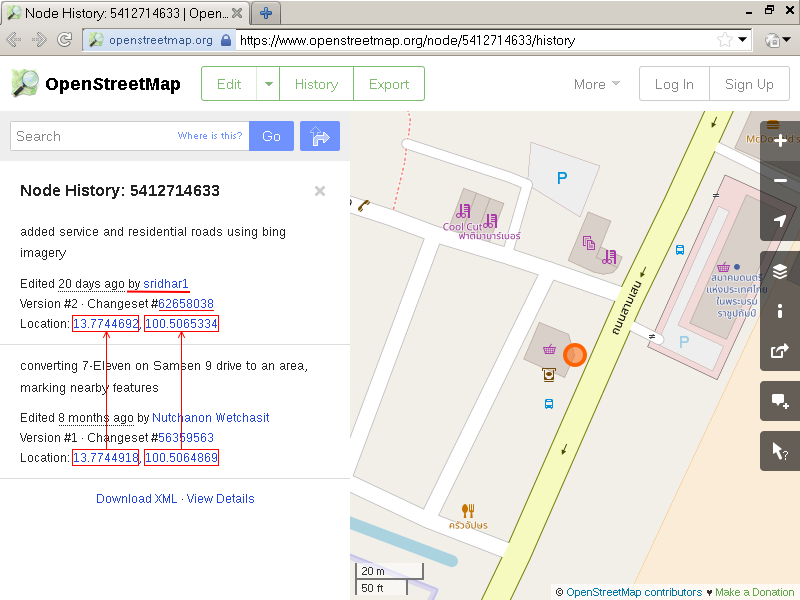
- A Krotron scale <https://www.openstreetmap.org/node/5412714632> is supposed to be a bit (~1 ft) eastward of the north-east corner of 7-Eleven.
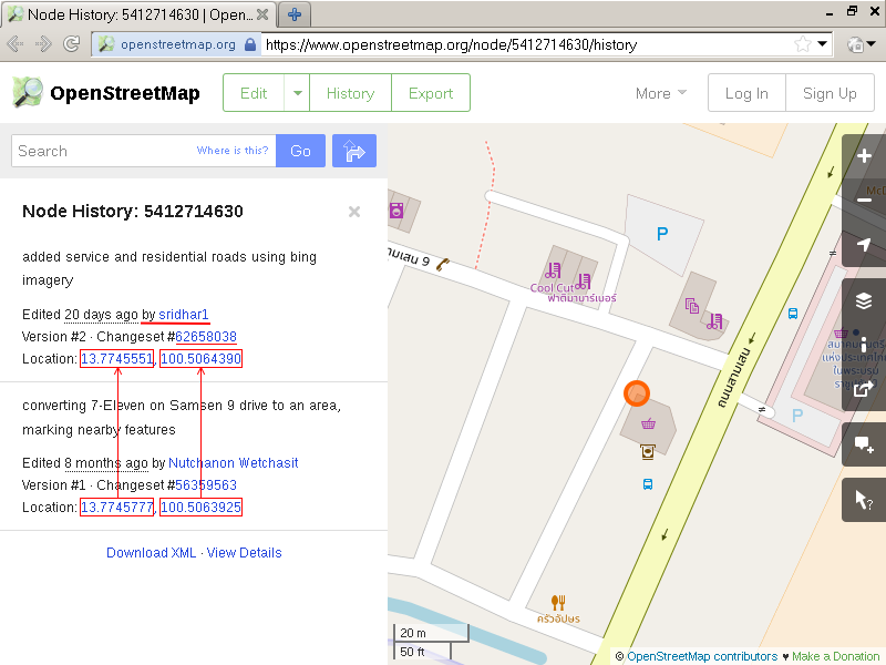
- A Boonterm mobile top-up kiosk <https://www.openstreetmap.org/node/5412714627> is supposed to be a bit (~1 ft) nothward of the east corner of 7-Eleven.
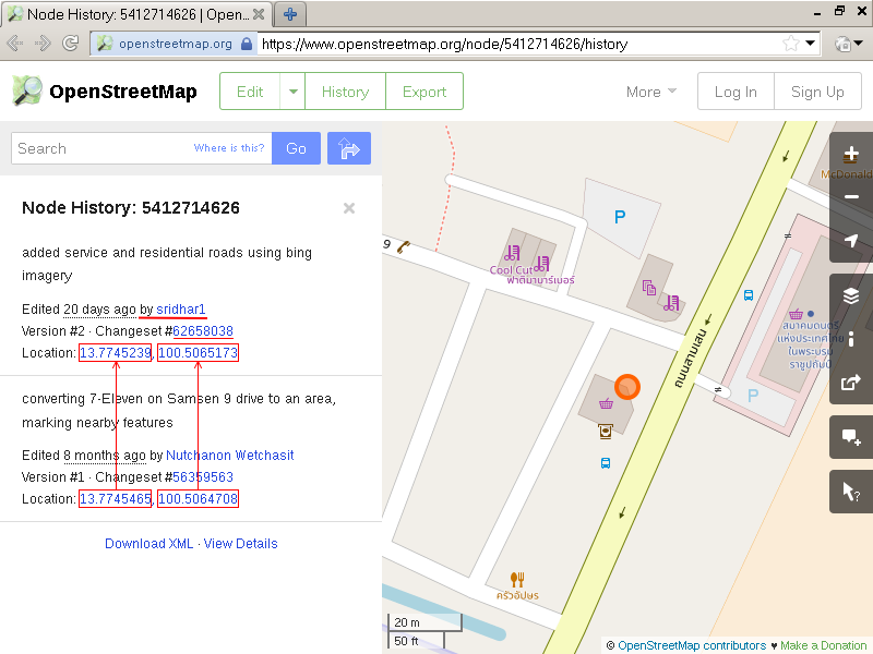
- A Bangkok Bank ATM <https://www.openstreetmap.org/node/5412714628> is supposed to be a bit eastward (~1ft) of the east side of 7-Eleven.
- A Siam Commercial Bank ATM <https://www.openstreetmap.org/node/5412714631> is supposed to line up with the Bangkok Bank ATM, parallel to the road.
- The bus stop <https://www.openstreetmap.org/node/4770201770> is supposed to be nearer to the road than any of these features. (Actually, it is ~1 ft from the _edge_ of the road)And all of them are /outside/ (NOT inside) of 7-Eleven. These details are all added from in-person ground survey, and most of them were also re-verified yesterday that they were what I just described.
Moving features to align them to (a newer) satellite image is not wrong in and unto itself. But in any case, always make sure to preserve local consistency in what you edit; otherwise there's no telling how many contributors' work that you have broken in the process.
This is especially important when you didn't walk up there to verify them in-person.
-
Comment from Nutchanon Wetchasit
Regarding satellite-based mapping and data precedence, see: <https://wiki.openstreetmap.org/wiki/Armchair_mapping#Imagery_can_be_wrong>
And also <https://wiki.openstreetmap.org/wiki/Armchair_mapping#Disadvantages_and_controversy>.
-
Comment from sridhar1
Hello Nutchanon,
With respect to connectivity,
Please accept my sincere apologies for the mistake
I did not intend to remove the connectivity, but the node must have been mistakenly moved. However, I should have checked from my side before uploading the change-set
Will be more careful moving forward.With respect to alignment effort, we checked all the way links mentioned, none of the existing data is aligned to any of the imagery available in Josm. Hence we aligned the existing data with reference to Bing Imagery.
We didn't find any existing imagery offsets used, and strava traces are not available for low priority roads in this area. Hence aligned basis Bing imagery.For node links mentioned. icons representing map features, we didn't make any changes.
Thanks for your understanding
Sridhar
-
Comment from Nutchanon Wetchasit
Let me repeat a part of my comment I said earlier:
> another thing that's not making sense about this edit is how *it modified the outline of 7-Eleven*
I said that "problem" about this part of the edit is the move of each node of /the store/. Affected nodes are listed below:
<https://www.openstreetmap.org/node/5412714633>
<https://www.openstreetmap.org/node/5156586984>
<https://www.openstreetmap.org/node/5412714629>
<https://www.openstreetmap.org/node/5412714630>
<https://www.openstreetmap.org/node/5412714626>And from your statement:
> For node links mentioned. icons representing map features, we didn't make any changes.
That is exactly the problem. Those features are tied (literally) to the walls of 7-Eleven, despite that fact that they are outside. (If you visited the store personally, you would have known better) Moving the outline of 7-Eleven /without/ moving those POIs along with it broke local consistency, flipping outside things inside, shifting things at corners to the side wall. These are wrong.
If you also moved the ATMs, scale, and the top up kiosk along with each corner of the store, preserving their relative position, I wouldn't have complained about this part of the edit.
But you didn't, so here we are.
-
Comment from sridhar1
Hello,
Apologise for not able to understand your feedback.
I tried checking the boundaries of 7 eleven and the nodes of POIs. None of them were modified by me.
Kindly take time to suggest how I go ahead and fix this issue and I will exactly follow your instructionsSorry again for the trouble
Thanks
Sridhar -
Comment from Nutchanon Wetchasit
> I tried checking the boundaries of 7 eleven
Which tool you used for checking the history again?
Since what you did was moving nodes (not adding or removing node to/from the way); checking history of the "way" won't do. You need to check history of each "node" that I pointed out in my last comment.
I used the node history page on openstreetmap.org, and it is quite obvious that this edit (attributed to you) affected the nodes' position. Screenshots below, red emphases are mine:
<https://u.cubeupload.com/xwindows/8wqgyN.png>
<https://u.cubeupload.com/xwindows/LhghfP.png>
<https://u.cubeupload.com/xwindows/kidDZz.png>
<https://u.cubeupload.com/xwindows/1RrBoP.png>
<https://u.cubeupload.com/xwindows/DrH0n8.png>> and the nodes of POIs.
This is correct, and the lack of said edits is a part of the problem I was speaking about in the second-to-last paragraph of my last comment.
> Kindly take time to suggest how I go ahead and fix this issue
No need, I have gone in and manually re-synchronized the local position of 7-Eleven relative to these POIs, then re-aligned global position of the group to the Bing 2018 imagery. This part is resolved in the changeset 63278653 <https://www.openstreetmap.org/changeset/63278653>.
There are more wrong things with this changeset in Samsen 9 drive alone; but they are not as critical as this one. So I will manually re-verify and correct each of them when I have time.
Lastly, I would have to point out that on OSM, data from local survey are always preferred over data from imagery-based mapping. And don't realign objects solely because they are slightly shifted from the imagery (they always do). Local coherency are far more important.
Also see <https://wiki.openstreetmap.org/wiki/Armchair_mapping#Disadvantages_and_controversy> again, especially point 4 in this case.
-
Comment from sridhar1
Thanks for the effort Nutchanon,
We will ensure existing data is not modified for alignment reasons unless there seems to be a major shift and or is leading to validation errors.
we are using Josm to check history of the segments.Thanks,
Sridhar. -
Comment from Nutchanon Wetchasit
This changeset is now partially reverted further in changeset 64133024 <https://www.openstreetmap.org/changeset/64133024>, on the attribute of first internal branch of Samsen 9 drive.
Reason: The branch way is heavily barricaded inside, and is only safe for walking by foot. Even riding a bicycle through it is a long shot; cars can't enter at all; re-verified by an on-foot ground survey.
-
Comment from sridhar1
thanks for valuable feedback and letting me know groundtruth realitty
-
Comment from Nutchanon Wetchasit
This edit is now partially reverted further via changeset 69633902 <https://www.openstreetmap.org/changeset/69633902> along the Samsen road.
Reasons:
- You added stairs to crossing in front of Saint Gabriel school that lead directly into the road- which are utterly false.
- You disfigured the east entrance driveway of Suan Suanandha university.
- You broke consistency of ordering between Musical Association of Thailand's entrance driveway and Samsen 9 drive. -
Comment from Nutchanon Wetchasit
> - You disfigured the east entrance driveway of Suan Suanandha university.
Correction: You disfigured the *west* entrance driveway of Suan Suanandha university.
Ways (1-20 of 39)
- 1
- 2
Welcome to OpenStreetMap!
OpenStreetMap is a map of the world, created by people like you and free to use under an open license.
Hosting is supported by Fastly, OSMF corporate members, and other partners.
| https://openstreetmap.org/copyright | https://openstreetmap.org |
| Copyright OpenStreetMap and contributors, under an open license | |