Changeset: 53689019
Add few streams, tracks, peak elevations
Closed by Nikita Kozlov
Tags
| created_by | JOSM/1.5 (13053 en) |
|---|---|
| source | knowledge |
Discussion
-
Comment from Mateusz Konieczny
What is the source of this edit? What is the source of data for this 1693 peaks? Is it OK to add it into OSM?
-
Comment from Nikita Kozlov
The source is laos maps of scale 1:50000 and 1:25000 done by webrian, few peaks (around of 50) were manually checked by me during our 7 years of caving expeditions into Laos, the difference between map-assisted positions and GPS are within 3 meters, so from accuracy point of view it is enough. About legality of maps - I have bough 1:25000 map scans in Berlin library (their scans), and share that peak knowledge with community, is that bad or wrong I do not know, but Haven't you been to Laos to check on field or you are just looking for social justice?
-
Comment from Mateusz Konieczny
"I have bough 1:25000 map scans in Berlin library (their scans)"
Have you checked copyright status of the maps?
See https://wiki.openstreetmap.org/wiki/Copyright and https://wiki.openstreetmap.org/wiki/Out-of-copyright_maps for details.
-
Comment from woodpeck
Dear Nikita, I'm with the OSMF Data Working Group dealing with legally problematic data sources. Please understand that any use of a copyrighted source - even with the best intentions or under the assumption that it was legit - has the potential to cause trouble for OpenStreetMap when the rights holders sue us, or maybe just discredit us as "data pirates". We want to respect copyright and only use sources that are either out of copyright, or openly licensed. Now unless those maps that you bought are old enough to be out of copyright, or unless they bear some sort of public domain dedication, then copying data from these maps into OSM is not legal, and we need to remove the data again. Can you tell us exactly which maps you took the data from - when were they published and by whom? And is all data that you contributed in Laos from these sources?
-
Comment from Nikita Kozlov
> Have you checked copyright status of the maps?
For 1:50000 - yes, they are AMS maps of 1960's Vietnam War era. See http://www.openstreetmap.la/downloads/?lang=en under Edit tab (TMS URL:
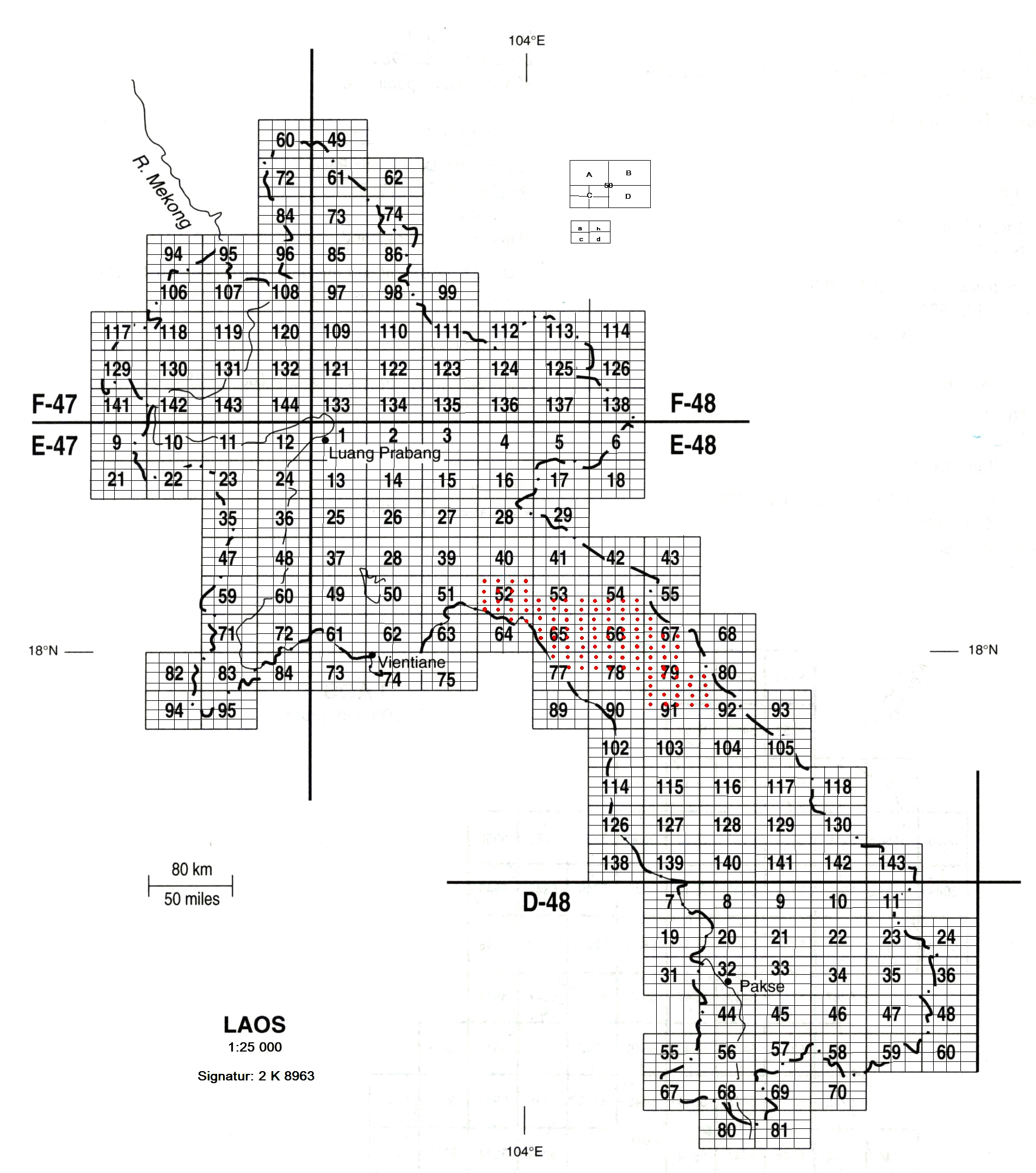
http://www.openstreetmap.la/tms/1.0.0/topomap/{zoom}/{x}/{-y}.png which serves topographic maps for northern Laos. These topographic maps from the 1960ies were made by the US Army Map Service in the scales of 1:200000 and 1:50000. Meanwhile these maps are released to the public domain and available at the University of Texas Libraries)For 1:25000 they are all from http://staatsbibliothek-berlin.de/fileadmin/user_upload/zentrale_Seiten/kartenabteilung/topo/2k8963.jpg , I ordered scanned copy, then properly geo-referenced them and took peaks from them. 1:25000 maps are from ~1993 year.
So I was thinking that there are no difference between University of Texas Library and Berlin library, because the map data in one way or another is public domain.
> And is all data that you contributed in Laos from these sources?
No, only peaks are from scanned maps. Again few peaks are GPS. Other my sources is Bing imagery, personal GPS tracks and conversations with locals to name caves properly etc.
Welcome to OpenStreetMap!
OpenStreetMap is a map of the world, created by people like you and free to use under an open license.
Hosting is supported by Fastly, OSMF corporate members, and other partners.
| https://openstreetmap.org/copyright | https://openstreetmap.org |
| Copyright OpenStreetMap and contributors, under an open license | |