Changeset: 142490559
add spanish signalling
Closed by AurélienQ
Tags
| created_by | JOSM/1.5 (18789 fr) |
|---|---|
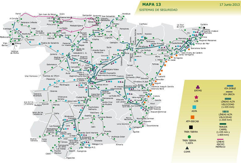
| source | https://www.vialibre-ffe.com/PDF/Mapa_de_RedFerroviaria_2013.pdf |
Discussion
-
Comment from Bauer33333
Hi, I like that someone is looking after the Spanish signalling systems, but I'm a bit concerned about the data quality. You tag a lot of tracks and there are some included that obviously can't have a protection system, like this one: https://www.openstreetmap.org/way/1124676235
Is this a mechanical edit? -
Comment from AurélienQ
Oh ! This is a mistake.
It's not a mecanical change : I select the ways who are suposed to have the ASFA signalling (according to the source I mentionned) ans I add the tag.
I trie to check every objects but doing it one by one is particulary long, so I do it globally.
Usually it works rather well, but it arrives sometime that some little mistake are inside the change.
I'm sorry about that, but I think it worth it.
If you see others errors, do not hesitate to fixe them.Thank you for your comment, I'll correct it and be more carreful about the future.
Have a nice day,
La Voie -
Comment from Bauer33333
No worries, I was just concered that there possibly could be no human at all behind this, no one putting thought in. Are you going to tag the railways without ASFA as well?
-
Comment from AurélienQ
First, I start with the railways with ASFA, because my source date of 2013, so I applie the principle that as principal signalling of Spain, it doesn't regress, but progress (it means that on the document, railways with ASFA still have ASFA actually, and whose without ASFA on the document, can potentially have ASFA today).
But I regognize the uncertainty of the process, so, if you find a source more recent, I take it gladly !
PS: I have an another source (https://www.vialibre-ffe.com/images/image/11162_01_sis_red_Seguridad.jpg), but harder to read, that's why I use the one I mentionned in the changeset. Globally, this second one confirm the first one, even if both date of 2013. -
Comment from AurélienQ
I wrote a long text and forget to respond you, so, yes maybe, next I'll map the railways without ASFA.
-
Comment from blacx
hello, I just found a better source, from 2023 straight from ADIF:
https://www.adif.es/documents/20124/12551086/20230329_03_DR_Adif_Mapas_2023.pdf/1bebcf92-7cdf-9941-3e67-e0986a80eb00?t=1680080010954page 8 for signaling
if you don't know what the legend mean, in general anything but BT or BEM is an automatic protection. For the exact type of signaling just look a the symbol next to de lines, blue square or green dot is ASFA, BT and BEM shoud be no protection. But be carefull because there can be automatic bloquing but without ASFA like Portbou-CerbèreYou should review what you have done, because you tagged Puigcerdà - La Tour de Carol with ASFA, but this section only has BT (BT means phone blocking (Bloqueo Telefonico)).
-
Comment from blacx
Although now that I look at it, it seems like Puigcerdà - La Tour de Carol has a green dot next to it, but i find it really weird to have a BT with ASFA
-
Comment from AurélienQ
I take it!
I compared the two, and globally it's the same map (because of the small difference of creation's date).
But I'll use it because it gives the OSM datas more respectful.
- 352650403, v5
- 352650406, v6
- 352808445, v4
- Línia de Vilafranca (353422905), v7
- FFCC Barcelona - Tarragona via Vilanova i la Geltrú (353422906), v13
- Via 8 (353422908), v6
- Via 6 (353422909), v7
- Via 18 (353422910), v6
- Via 14 (353422911), v7
- Via 16 (353422912), v6
- Via 12 (353422913), v7
- RT2;R13;R14;R15;R16 (353422914), v6
- 353422915, v5
- Via 17 (353422916), v5
- 353422917, v9
- 353422919, v5
- Via 15 (353422923), v6
- FFCC València - Sant Vicenç de Calders (353422924), v14
- 353422925, v5
- Via 20 (353422926), v5
Welcome to OpenStreetMap!
OpenStreetMap is a map of the world, created by people like you and free to use under an open license.
Hosting is supported by Fastly, OSMF corporate members, and other partners.
| https://openstreetmap.org/copyright | https://openstreetmap.org |
| Copyright OpenStreetMap and contributors, under an open license | |