
Views from Gedling Country
Posted by alexkemp on 26 March 2017 in English. Last updated on 4 July 2022.My current mapping is on the eastern edge of Gedling. Gedling prides itself as a village, with an Anglican church that was established in 678 A.D. (the current church is a youngster at 1089 A.D.). Today, someone that lives in a bungalow at Field Close at the rear of the church was proudly pointing out to me the Peregrines that lodge in the niches of the spire. The tower is 90 feet high (27.4m) and the spire is yet another 90 feet, so that gives those dive-bombers an unrivalled perch for launching their attacks.
In spite of it’s history, Gedling is now more or less just another suburb of Nottingham. It does, however, skirt the countryside and I’m mapping on the edge of that country, so here are some views.
Want any Horse Sh.., er, Manure?
Glebe Farm is an abandoned stables just outside of the residential spread that has crept up Lambley Lane. It has suffered decades of blight due to development, the latest of which (“Gedling Access Road”, or “GAR”) looks like it may go ahead. There were some horses in the East fields, a Detectorist scanning the West fields, and below is Milo the dog, an energetic bull terrier that belongs to the lady that looks after the horses. Milo leapt up at me & introduced my buff-coloured trousers to the farm speciality (there are twin piles of the stuff in abundance near the gate if your garden needs any).

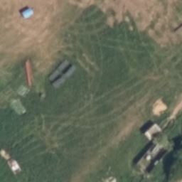
Evidence of Strip Farming in Glebe Farm West Fields
A chap in Jessop Lane (the road formerly called “Hanging Lane”, since those due to be legally despatched were marched up that lane to the gallows up on top of the hill) pointed out that Glebe Farm’s West fields still show signs of the way that they were used hundreds of years ago as common-land strip-field farming. That evidence is all due to be lost under tarmac if the proposed developments go ahead (it all looks full-steam at the moment), but can currently still be seen in either Google Earth or Bing (the Bing-tile below has had a capture date of 2011/10/1-2012/3/26; the construction at bottom right is a Western Power sub-station):
…and here a recent photo attempting to show the same phenomenon in the same field (it can easily be seen with the naked eye but would need different lighting conditions to be so easily seen with a photo) (the Western Power sub-station is just out of view on the RHS of the picture):–

The Road Less Well Travelled
The next sight may not seem much, and indeed was shot only so that the embedded GPS in the photo could locate the position of the 30/40 mph signs, but it is, for me, also a classic view of English country-roads (all orphaned now by the GAR):–

Doggedly Well Ensconced
This next view of an English country house is also a side-product of the GAR & development, as the couple of acres of grass & trees between The Kennels (an ancient name on that land) & Lambley Lane is now owned by the local Council & no building takes place until the future reveals itself:–

Update 5 July 2022
Mapillary has changed it’s download URLs & therefore all links within my diaries that used photos stored in Mapillary in the old format are broken. I’m slowly going through to update them. The new URLs are terrifyingly long, but show OK on my screen (and I hope also on yours).
Discussion