OpenStreetMap

scruss's Diary

Recent diary entries

Don't name your "landuse="s …

Posted by scruss on 3 September 2023 in English.

… unless you want a greatbighuge label inexplicably hovering over the map at z=16.

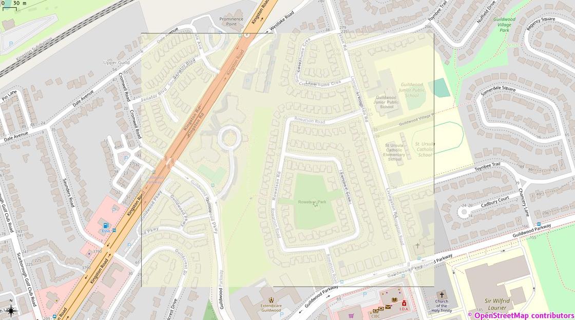
Looking over this fine city of Toronto, I saw a couple of brown labels for places that are sort-of not real. Exporting and grepping local exports showed me they were landuse ways with a name value set.

I’m sure there are plenty of good examples where a landuse area would have a name. In these cases, though:

  • one was the name of a city/developer study from roughly five years ago that has disappeared from the record since then. Will it become a neighbourhood name? Who knows, but that’s for the future and not for us to force. (fun fact: it’s apparently the densest concentration of office workers in the city. Less fun but very Toronto fact: there is no dedicated transit there. I had a job there ~2006–2008 and new transit was planned, but then the trainwreck formerly known as Mayor Rob Ford happened so it didn’t.)

  • one was a drive-by tagging error by an out-of-band specialist. I really think they meant it for a bus stop.

Aligned with my personal policy of “Only kvetch after fixing”, they’re gone and our z=16 will be so much less jarring. Thank me later.

Toronto Police Service has major, systemic problems. But they also have this one:

TPS tweet image of Rowatson Park, Scarborough overlaid on OSM tiles in QGIS

This is my hastily-georeferenced version of the image from this Toronto Police Operations tweet over OSM tiles in QGis. Note the extreme similarity between the streets and building detail. But also note the complete lack of OSM attribution on TPS’s map …

Location: Upper Guild, Scarborough—Guildwood, Scarborough, Toronto, Golden Horseshoe, Ontario, M1E 1N9, Canada

Dear OSMers —

The Proposal for a DIRECTIVE OF THE EUROPEAN PARLIAMENT AND OF THE COUNCIL on copyright in the Digital Single Market COM/2016/0593 final - 2016/0280 (COD) is a European thing.

I’m Canadian, in Canada.

There’s nothing I can do about your laws.

Please don’t act as gatekeepers of the world’s map by taking away features as a “protest” against something that users can’t change. I’m sure the EU is quaking in its boots over the inability to query OSM today.

Update: apparently there’s a banner with a link to https://savetheinternet.info/demos on the map today. TIL there are folks who don’t adblock everything.

Laser-etched edge-lit sign

(or if image link doesn’t work - https://scruss.com/blog/2018/12/17/they-wont-miss-our-table-at-the-next-mappy-hour/)

How to make this: Edge Lit Acrylic Frame - 100 × 100 mm by scruss - Thingiverse

Logo derived from Monochrome sticker on OSM logos page. Would be happy to share if anyone wants it.

Location: Scarborough Junction, Scarborough Southwest, Scarborough, Toronto, Golden Horseshoe, Ontario, M1K 3L4, Canada

give the hackerspaces some love

Posted by scruss on 29 January 2018 in English.

So my new job needs me to meet with many hackerspace/makerspace organizers in my area. You’d think they’d all be up on OSM, right? Nope.

Most of the leisure=hackerspace entries in Canada are wildly out of date. Quite a few had shut down, and many new ones haven’t been added.

While we can’t exactly import directly from HackerspaceWiki, it’s a good place to start. Sure, it’s out of date in places, but at least it gives you names and websites to research near you. If the space is still active, it’s probably got a few recent Twitter mentions or an active blog.

The new job? Thought you’d never ask. It’s the regional organizer for Makers Making Change. We use makerspace technology to get open-source assistive technologies to people with disabilities who need them.

multilingual names in Canada

Posted by scruss on 19 August 2017 in English.

Something in the weekly newsletter caught my eye:

Miguel Sevilla Callejo (msevilla00) from Zaragoza, Spain, is currently in Wales. He noticed an inconsistent use of English and Welsh in OpenStreetMap. His email resulted in a readable, long-lasting and controversial discussion on the Talk-GB mailing list (threads in July and August) and comments in an OSM changeset. Nearly the same problem in Switzerland – read the following article. 😉

http://www.weeklyosm.eu/archives/9374

Miguel Sevilla Callejo (msevilla00) de Saragosse, en Espagne, est actuellement au pays de Galles. Il remarque une utilisation pas toujours cohérente de l’anglais et du gallois dans OpenStreetMap. Son courriel a donné lieu à une longue et controversée discussion sur la liste Talk-GB (juillet et août) et des commentaires dans un changeset OSM. Presque le même problème en Suisse – Lisez l’article suivant. 😉

http://www.weeklyosm.eu/fr/archives/9374

So I went to the “Multilingual names” page https://wiki.openstreetmap.org/wiki/Multilingual_names and found Canada conspicuously absent. Is this because:

  1. we’re already doing it perfectly in Canada; or
  2. local mappers already know what they’re doing (an argument that seemed to be dismissed in the original discussion about Wales); or
  3. nope nope nope not touching that with a rad-hardened barge pole?

via The RISKS Digest Volume 30 Issue 04:

Rail Crossing Warnings Are Sought for Mapping Apps

http://www.nytimes.com/2016/12/19/technology/google-digital-maps-railroad-crossings-ntsb.html

The National Transportation Safety Board asked tech companies to add the locations of grade crossings into digital maps and to provide alerts for drivers.

So the US NTSB are asking “the other map companies” to provide locations of railway=level_crossing or at-grade intersections of highway=* and railway=* ways? Hmm, if only they knew people not just providing ad platforms as scrolly bitmaps to further distract drivers …

Location: Scarborough Junction, Scarborough Southwest, Scarborough, Toronto, Golden Horseshoe, Ontario, M1K 3L4, Canada

On the corner of $FIRSTNAME and $LASTNAME

Posted by scruss on 19 November 2016 in English.

My name is a problem. Not merely is my first name often misspelled (and, where I now live, almost universally mispronounced) it’s often assumed to be my family name. While it’s pretty common for Scottish guys to go by their middle name, since they’ll often have the same first name as their father¹, my first name really is my given name. It’s just my luck that my family name is more common as a first name. Also, my name is really long; with my middle name, it’s too long for Canada’s ID system, so I have an “official” name² that’s my real name minus a letter or two. I should just add LLC on the end and be my own legal partnership. Hence, it’s a lot easier to go by my nickname.

A friend’s rather odd quest to see how many of his Facebook friends had their names mentioned in Milwaukee streets led to me creating a list derived from OSM data³ for him. That got me wondering further: is there a city in the world where Stewart Street/Road/Avenue/… intersects with Russell Road/Street/Avenue/…?

Before I get preemptively banned from Overpass Turbo for life for thinking up the most futile way to heat up a server, I’ll probably never do this. If I did, I should probably just look in New Zealand⁴, because it often seems — in place names, at least — to be more Scottish than Scotland.


¹: This can make lowland Scottish genealogy an interesting challenge. I think I’ve got something like five consecutive generations of Roberts marrying Agneses in my ancestry; imaginative we ain’t. I do have to keep reminding myself that my lot were the ones who didn’t have the get-up-and-go to become hillbillies.

²: no, I’m not getting all Freemen-on-the-Land nonsense on you here. Just in case you were getting worried.

³: it’s here, along with instructions on how I did it: Milwaukee Street Names from OSM for Jeff

⁴: My ancestry does have a slightly more Highland branch, of whom I’ve written here before. My grandfather remembered his grandmother describing seeing the boats leaving to take the Stewarts of Appin to New Zealand during the Clearances.

Location: Bay View, Milwaukee, Milwaukee County, Wisconsin, 53207, United States

For years, I knew there was an address hole in OSM along Eglinton Avenue East. Querying Nominatim for an address would often return a location ≥ 5 km away from the real result.

Then came Metrolinx’s clean up and import of address ranges. Folks might turn their noses up at address ranges, but at least ranges give you a location within a few metres without adding millions of nodes. This is good enough for Metrolinx’s commuters, and improves the map.

A couple of days ago, I had to look up an address while mobile on Eglinton East. All I had was my phone with Google Maps. I put in the address, and Google suggested somewhere really far from where I’d expected it to be. Oddly enough, Google was suggesting a location in the general area that OSM always used to return. How nice to know our addresses can be more useful than those provided by a corporate entity!

Location: Victoria Village, Don Valley East, North York, Toronto, Golden Horseshoe, Ontario, M4A 2B1, Canada

Does this look like a theme park to you?

Posted by scruss on 5 November 2016 in English.

Markham Fair Grounds

These are the Markham Fair grounds. I missed out some of the grass, and the track, but this is pretty much what you get. It doesn’t look much like tourism=theme_park, does it? But that’s how it’s currently tagged: Way: Markham Fairgrounds (43934707)

Strangely enough, it and many others like it in Ontario are tagged as theme parks. Now they might have a midway for a week or so during summer or fall fairs, but the rest of the time, they look like this.

The previously proposed amenity=show_grounds would be better for most of these. The ones that have permanent installations, like Canada’s Wonderland, should stay as theme parks, so a little local knowledge is required.

Location: Markham, York Region, Golden Horseshoe, Ontario, Canada

The Great Canadian Mailbox Heist

Posted by scruss on 7 October 2016 in English. Last updated on 4 January 2017.

Dropping off a letter in the mailbox at the end of the street, I noticed this sticker was attached: Mailbox, aka node 551077710 
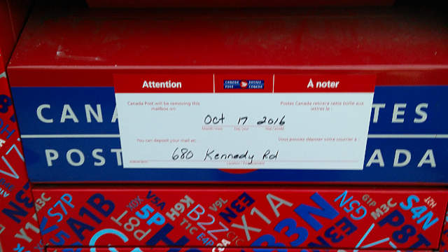
So that means by the middle of the month my leisurely 400 metre round trip to post letters is going to be over a kilometre, either to Mailbox: Node 705233932 or to the suggested Mailbox: Node 4433576259.

I looked around on the map for more amenity=post_box nodes around me, and found coverage was patchy. Local mapper andrewpmk has done some sterling work adding mailboxes, but there are some neighbourhoods even he can’t find time to go into. But there has to be a definitive list of mailbox locations in Canada, somewhere, right?

Wrong: Canada Post does not publish mailbox locations. There’s no way of finding a list or map on their website, and Canada Post confirmed to me that “we do not have a map for street letter boxes”. So it looks like we’re the only people mapping them, unless there’s a list I can get via an Access to Information (Freedom of Information) request.

2017-01-04: Update: disappointingly but unsurprisingly, they refused.

Location: Scarborough Junction, Scarborough Southwest, Scarborough, Toronto, Golden Horseshoe, Ontario, M1K 3L4, Canada

The Canadian Internet Policy & Public Interest Clinic (CIPPIC) has an interesting piece on the legal risks of contributing to and using Volunteered Geographic Information … in other words, OSM: Volunteered Geographic Information FAQ.

The document makes a few observations (from a Canadian legal perspective) that mappers might find useful. In summary:

  • As a mapper, you’re unlikely to be sued if you add incorrect data to OSM. But you wouldn’t (knowingly) do that, would you?

  • OSM (or OSMF, most likely) would unlikely be liable if map data were relied upon in an emergency and found to be incorrect. There are many nuances to this, so it’s better if you read the When would a VGI website be liable in negligence for inaccurate information? section yourself.

  • In order to limit its liability, OSM should “… also make sure that their software is running smoothly, and that the visual designs of the sites are clear and informative.” Hmm.

(Incidentally, CIPPIC is also responsible for the excellent-though-depressing CIPPIC Licensing Information Project for Open Licences, CLIPol. If you want to see how not to do open data, take a look at some of the really bad licences they’ve found. I wonder why so many of the terrible “open” government licences are near me?)

Map Maker Canada schadenfreude

Posted by scruss on 6 February 2016 in English.

Aww — looks like Google Map Maker is editable again in Canada. It’s got some restrictions now, including one that The Great Unwashed can’t edit polygons any more (which, in my ‘hood at least, means no more polygons nicked wholesale from OSM). But the main new feature is: “Top mappers in your country are now empowered to moderate your edits”. These Regional Leads bless your edits … once they get around to it.

Seems that most of the comments on the Canada forum are of the form “I added my business X months ago, why hasn’t it shown up?”

Now, if only there were a thoughtfully moderated alternative to Map Maker out there … ☺

OpenStreetMap: Building a great map while everyone tells you you’re doing it wrong

Notes/Links:

  1. ‘The Map’ — http://www.openstreetmap.org . It supports routing now, too.
  2. QGIS, an open GIS manager. It’s rather good — http://qgis.org/
  3. The OSM Wiki; ridiculously complete documentation: https://wiki.openstreetmap.org/wiki/
  4. OSM Help Stack Exchange-style question/answer: https://help.openstreetmap.org/
  5. All of the OSM stats! — https://wiki.openstreetmap.org/wiki/Stats
  6. Toronto map growth animation — http://www.geofabrik.de/gallery/history/index.html#toronto
  7. Crowdsourced geocoding (+ lawsuit from Canada Post) — http://geocoder.ca/
  8. Open Data Commons Open Database License (ODbL) — http://opendatacommons.org/licenses/odbl/
  9. Canada’s new Open Government portal — http://open.canada.ca related: Toronto Open Data — http://toronto.ca/open
  10. CIPPIC Open Licensing Project (CLIP) — http://clipol.org/
  11. Humanitarian OpenStreetMap Team [HOT] — http://hotosm.org/
  12. OpenCycleMap — http://www.openstreetmap.org/#map=13/43.6666/-79.3785&layers=C
  13. The rather wonderful /uMap/https://umap.openstreetmap.fr/en/

spam users ☹

Posted by scruss on 20 April 2015 in English.

I dunno what it is about a certain kind of solar power sales person, but they’re all about the spam. In trying to find details for tagging solar hot water heaters, I found a couple of no-edit accounts with word-number-word algorithmically-generated names: push36queen and cry3dime

There are probably more.

If you do happen to be looking at how to tag solar hot water, this looks about right: Node: 2671563575