
Last time I tried to do an import, things ended up a bit ugly. I prepared all the data transformations and processes, but I did not receive the permission to use the dataset from Boston GIS, and I was not able to contact anybody from the GIS department. So I gave up. And learned from my mistakes.
After spending some time untangling the lanes on nearby highways in Greater Detroit Area and adding 5 square miles of residential buildings just because why not, I decided to see whether there is any open dataset available to tag these buildings with addresses.
After being told by my city officials that neither they nor the county we are in provide any data, I kept my hopes low.
SEMCOG
Two days ago I discovered SEMCOG, the Southeast Michigan Council of Governments, and today I wrote them for permission to import their data into OpenStreetMap.
Their coverage is huge:
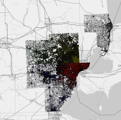
The data provides the addresses, building footprints, even median height of the features, so it will make Detroit area much easier to navigate using only OpenStreetMap.
At some point SEMCOG have hosted a #Maptime event, but I was not able to find any reference of this organization in our Wiki, and it feels like we should know about it.
Now, this post is just me sharing the excitement, so I am going to proceed with posting to the import mailing list, planning, transformations, and scripts only if permission is received from SEMCOG.
Discussion
Comment from Omnific on 29 December 2016 at 16:39
That’s fantastic to hear, great job and good luck!
Comment from Alan Bragg on 31 December 2016 at 01:07
We miss your enthusiasm in Boston..
Comment from mvexel on 5 January 2017 at 18:27
Very cool, good luck!