
London mapathons: switching the emphasis to JOSM
Posted by pedrito1414 on 12 May 2016 in English. Last updated on 14 May 2016.There has been a lot of chat on the HOT list about validation and a lot of that has focused around tools that new mappers use. It is obviously tiresome for validators to be squaring buildings endlessly or dealing with validation issues that would have been picked up by the original mapper at the touch of a button in JOSM, but that are invisible for those using iD.
In response, we have decided to start trying to work out better and quicker ways of moving people to JOSM at the London Missing Maps mapathons.
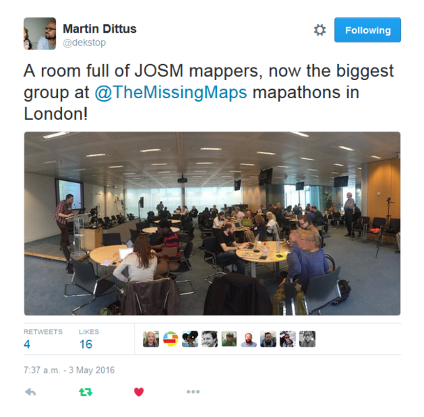
The first try at this happened in May. Using the eventbrite system to register participants to certain categories of ability has been our modus operandi for a while, so we simply upped the percentage of places available to those who wanted to learn JOSM and reduced the iD places. We also emailed ahead to our JOSM-experienced mappers to ask if they would mind making an effort to sit with, and support, the newbies.
Robert led an impressive, three hour walk through that mappers could dip in and out of and answered specific questions as he went.
From chatting to people there, not as much actual mapping was done. Despite asking all people to download and install the software before they came, there was still a fair amount of troubleshooting to do in this respect. We will see how the validating goes on the task we tackled. Feedback from validators looking at this task more than welcome!
I’d also love to hear from others organising mapathons where JOSM is the primary tool and from new mappers who have learnt to edit OSM with JOSM, or a combination of JOSM and iD. How did it work for you? What kind of training or resources worked best? What elements of the tool is it important to learn first? Any other comment?
Looking forward to taking this further…
Discussion
Comment from Richard on 13 May 2016 at 08:13
I don’t really have any skin in this game as I use iD infrequently and JOSM basically never, but what’s your “squaring buildings” issue in iD? Select any building in iD and there’s a “Square the corners of this area” option right there, with a key binding described.
Comment from pedrito1414 on 13 May 2016 at 08:28
Absolutely! However, we still get new mappers who map weird and wonderful shapes for buildings that are essentially rectangles… However, new mappers using JOSM, which has the building tool (automatically plots your buildings with right angles) tend not to make that mistake.
Comment from robert on 14 May 2016 at 10:13
Though I think it’s important that we don’t go too far with this - we will always have contributors dropping in & out of engagement and we must always make the “onboarding” stream a welcoming thing to replace those who will naturally drop out. We may feel quite volunteer-rich at the moment, but we might not always be in that position.
We don’t want to find ourselves up a mountain with all the sherpas dead.
Not sure if that analogy makes any sense.
I also think there’s an argument to be made about diversity in favour of retaining an iD contingent. There will always be a “demographic” of user for whom JOSM will always be too much (or just the install process, or maybe it won’t install on their computer…) and casting off those users also casts off the friends that they might have told about missing maps, who again might be a broader demographic…
Also having most users start off with iD means they’re all aware that they can edit OSM anytime from just a browser, not requiring any java-install-nonsense.
Comment from bgirardot on 14 May 2016 at 11:37
I whole heartedly endorse this idea Pete!
iD is about to turn awesome with its own building tool and switching imagery if you read the iD github issues.
But JOSM is not that much more difficult and it is mainly a training issue in its use because the UI is just slightly more complicated than iD’s
Thank you for working with your well established group of humanitarian mappers to explore the best practices for teaching new OSM mappers to use JOSM, this will be invaluable.
Please pass on my thanks to the MM London mappers for their help with this, it is really important to help OSM in this way and their contributions to helping determine best practices for training are a great contribution.
Hope to see you there!
Comment from Yann Vandamme on 20 May 2016 at 11:30
I started mapping at a mapathon in iD not that long ago, and it was made very clear by the instructors to “Always” if not “as much as possible” use the “squaring buildings” options in iD for the buildings mapped. It was also explained why this squaring was so important.
In my opinion, it’s just how you instruct new mappers. If the new people follow the instructions of experienced mappers to the letter, all will be OK for validation?
I did my first tries in JOSM recently, but will need to look at much more tutorials first, before I can actually use the program correctly. There are so much options there, you get a bit lost at first.
What iD could use is an option that points you to possible inconsistencies in your mapping, and maybe also suggests you how to solve them? Are people who make errors in mapping given feedback by validators, that might be handy?