OpenStreetMap

aHaSaN's Diary

Recent diary entries

Integration of OSM based participatory mapping into LoGIC Project of UNDP Bangladesh

Posted by aHaSaN on 26 August 2018 in English. Last updated on 2 September 2018.

A Brief on LoGIC

LoGIC (Local Government Initiative for Climate Change) is a multi-donor collaborative initiative of GoB, UNDP, UNCDF, EU and SIDA, aims to enhance the capacity of vulnerable communities, Local Government Institutions (LGI) and civil society organisations for planning and financing climate change adaptation solutions in selected climate vulnerable areas. The Local Government Division (LGD) is the implementing lead of the project in partnership with UNDP and UNCDF (for technical and management support) in 7 (seven) districts (Kurigram, Sunamganj, Khulna, Bagerhat, Barguna, Patuakhali, and Bhola) of Bangladesh designed to support roughly 200,000 most vulnerable households in 72 (seventy-two) unions. The benefits are expected to come out of climate change adaptation actions at various levels, scaled up through local government institutions incorporating high quality accountability and participation of the most vulnerable people.

Vulnerable people living in disaster-prone areas of Bangladesh have developed strategies and practices to cope with these natural events; however, they have inadequate empowerment to influence over development planning in their communities. In order to address the vulnerabilities of Bangladesh to climate change, the project envisages the following priority areas of action:

  • Building capacities of individuals and households with information, knowledge, skills and technology to adapt to climate change as well as leadership skills to influence the local planning process.
  • Build capacity of the local NGOs, CBOs, local institutions and LGIs in climate change integrated planning, budgeting and implementation with high degree of accountability and inclusive practice.
  • Provide funds to LGIs and vulnerable households to plan and implement climate resilient activities and interventions at community and household level.
  • Generate knowledge and mobilise opinion for shaping a Local Climate Fiscal Framework and enhance readiness of both LGIs and the Local Government Division to utilise national and international climate finance in an accountable way.

These priorities will be addressed through three sets of core actions: capacity building, providing access to climate change funds and policy advocacy. During the planned support period, the proposed project is expected to produce following three key results:

  • Firstly, the capacity of local governments, households and other local stakeholders will be increased enabling them to enhance existing and future local development plans by integrating climate change adaptation solutions.

  • Secondly, a financing mechanism for local governments to implement climate change adaptation solutions will be established; the Performance Based Climate Resilient Grants will be aligned with the current system of fiscal transfers to Local Government Institutions using and improving it. It also covers the design and implementation of a Community Resilience Fund that will provide resources for community and household level climate change adaptation solutions for vulnerable households.

  • Thirdly, it is of upmost importance that the pilot experience gained at the community and local level is informing wider policy and practice and ultimately aim at improving and reforming the planning and financing system of the GoB for CCA at local and community level, ensuring sustainability beyond the project.

OpenStreetMap Integration

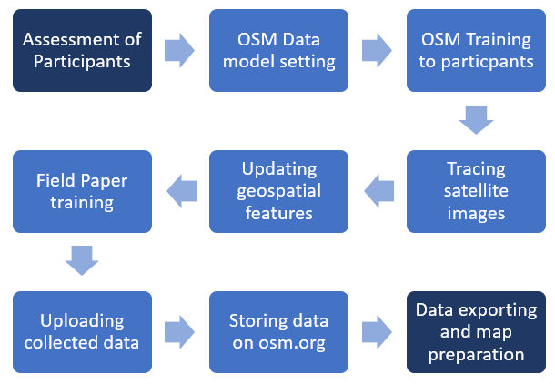
Though LoGIC project is working to establish climate resilience community functions and infrastructure as well as climate resilient households and individuals, it intends to collect geospatial data of Union and produce geospatial map by participatory mapping of its intervention area. As a result, LoGIC project hired Mr. Ahasanul Hoque as a consultant to support in participatory GIS mapping/OpenStreetMapping, updating OSM based geospatial risk data as well as to incapacitate local facilitators on the participatory mapping process. During the Community Risk Assessment geospatial data of Union will be collected and using these data geospatial map will be created. The map will be assumed as the baseline map of the particular Union Parishad. The follow of work will be:

  • OpenStreetMap training to strengthen selected project staff as well as locally recruited volunteers/enumerators to support the participatory GIS mapping process

  • Providing guideline to the local enumerators to embed the participatory GIS to the CRA Social Mapping process

  • Creating OpenStreetMap database for target unions and store database on open source map data portal

  • Uploading the collected field GIS data and updating on OSM portal

  • Accommodating geospatial data into the ATM System of the Project

Methodology

Methodology.png

Participatory Mapping and data Collection at Field

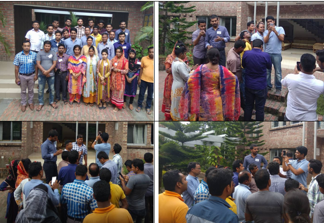
The local facilitators selected by LoGIC project in each of 7 target distracts have got the field data collection training. They are collecting the amenities’ location using GPS Logger and field papers along with all CRA information.
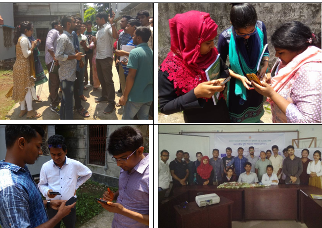
 image.png

image.png

Data Team

.To create the spatial database for the target area by tracing existing visible features in satellite images on OpenStreetMap editing software (iD Editor and JOSM) a training was given to the LoGIC OSM data team. A mapathon was arranged to trace the target unions of Seven Districts. This data team is responsible for field data cleaning, uploading according to the concerned tags.
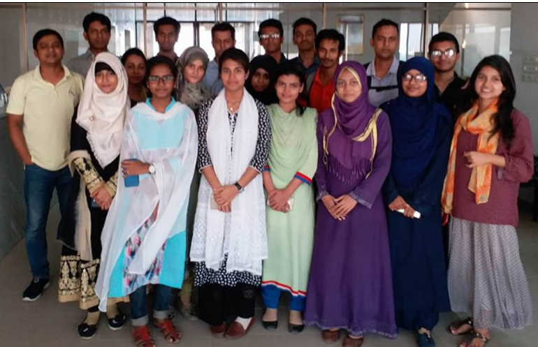
DHk_team.png Data Team

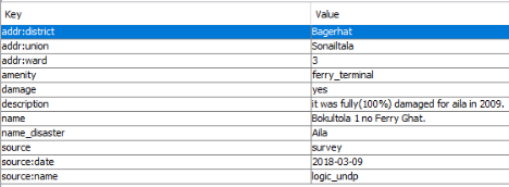
OSM Tag used and Data Uploading

  • addr:district =
  • addr:union =
  • addr:union =
  • amenity =
  • damage =
  • description =
  • name =
  • damage_name =
  • source =
  • source:date =
  • source:name = image.png

Conclusion

The OSM data team of LoGIC project is translating, cleaning all the data coming from the unions of seven dsitricts, uploading the data on OpenStreetMap for public sharing, consultant also preparing the shape files for all concerned unions to the CRA report team for updating their union elements’ maps. The team is working according to the coordinated approach set by the consultant and getting feedback for any issue rises during translation, uploading and editing the features on OSM portal.

Since OpenStreetMap allows users to see locations, events, features, and changes with unprecedented clarity, showing current information with past description, history etc what offer a wide variety of analytical tools to meet the needs of many people, helping them make better monitoring and decisions about the target area/s. Therefore, these LoGIC CRA OSM database could be a vital resources for any other climate change, resilience or disaster projects in the target unions of Bangladesh. This database will also help to complement policy advocacy, resilience for any natural or climate impact, ensure the transparency in resource allocation and better monitoring.

Location: Taltola, Agargaon, Dhaka, Dhaka Metropolitan, Dhaka District, Dhaka Division, 1916, Bangladesh

Over time the number of OpenStreamMappers is increasing, almost every day the community is getting new Mappers. Indeed it’s a great news but, a matter of tension as well in terms of data quality because of the no or minimal knowledge of tagging, proper drawing, and the fate or end use of data. Its a great news for us that recently a java based android application has been developed what is suitable for new mappers for collecting data in the field offline. It uses Mapzen vector tiles for display. Thanks to Tobias Zwick Street_Comp.png

Let me introduce you the application named streetcomplete.

  1. Download it from Google Play Store
  2. When you have an internet connection, find the place where you want to map, then you can stop the internet. you can find the area using your current location using mobile data.
  3. You will find the map tile with different features icon. Tap the icon and fill the answers generating against each feature like road, playground, building, path etc. Street_Comp_2.png
  4. After collecting data, upload your answers using the internet.
  5. Dont forget to authorize your OSM account from settings menu of the app.

Enjoy mapping. ~ AHASAN

N.B: The app is aimed at users who do not know anything about OSM tagging schemes but still want to contribute to OpenStreetMap by surveying their neighbourhood (or other places). Because of the target group, the app only presents issues which are answerable very clearly by asking one simple question, and which involve very few false positives.

Location: Dhanmondi Residential Area, Dhanmondi, Dhaka, Dhaka Metropolitan, Dhaka District, Dhaka Division, Bangladesh

First, I would like to congratulate the YouthMappers at AUW for wining the HOT micro-grant award with other seven communities globally. I would also appreciate other micro communities and chapters for competing the micro grant program and wish you luck for the next one. I would like to congratulate YouthMappers DhakaCollege, YouthMappers at AUW for wining 2017 chapter award, Maliha Mohiuddin from OpenStreetMap Dhaka University for wining best blog award 2017 and also other three chapter members for wining the leadership award and going to participate in workshop to be held in Nepal.

Let me give you some upcoming mapping programs that are under discussion but hoping to be launched soon:

  1. There will be a series of mapathons for mapping the existing features of 13 coastal districts of Bangladesh what we want to organize in a different manner. We will call for application/proposal from chapters, micro-communities, universities who wants to hold the mapathon/s at their premises. The selected will have the required training, logistics, appreciation certificate. I shall call for the application within a month or two.

  2. BDRCS Volunteers are going to be engaged soon for community level training and mapping. We are planning to expand the mapping of vulnerable buildings for urban resilience where the city ward emergency response committee members will be taught how to and map their respective wards. In near future we want to replicate for disaster vulnerable districts too.

  3. To find and enhance more use cases of existing OSM data in Bangladesh we would like to call for participation of a research teams, person/s in a research grant program . The selected teams or persons have to come up with scoping ideas showing result of spatial analysis, vulnerability assessment, risk analysis, scenario modeling or future projections. I will invite the potential universities and also open call for other researcher or team when we are ready.

  4. I want to map the Nijhum Dwip - নিঝুম দ্বীপ, one of the most vulnerable island in Bangladesh where loss of lives and livelihoods are common matter due to cyclone and storm surge. I would request some volunteers to assist me in field level data collection and mapping in next month.

  5. Finally, I am very happy that more and more service delivery and routing startups are using OepnStreetMap for their application. NerdCats team is going to update their Bus rout app based on openstreetmap after their famous and successful app GO! Traffic Updates (by GObd.co). Pathao service wants to use and update the roads of whole Dhaka city, for that they are going to organize a mapathon in 29th of this month jointly with OpenStreetMap Bangladesh community. I am requesting all the members of our community to join this mapathon and help Pathao to make a better and detail dhaka map.

Thanks. I wish you all the best in coming days. Happy new Bangla Year 1424.

My Manifesto for HOT Board Member Position

Posted by aHaSaN on 23 March 2017 in English. Last updated on 24 March 2017.

“Love and Compassion are necessities, not luxuries. Without them humanity cannot survive”. - Dalai Lama

Hello, voting members! I am Ahasan, I belong to the coastal district Khulna of Bangladesh. I truly believe in humanity and continuously strive and work towards humanity because my motto in life is ‘if you want to leave a mark in the world, work for the humanity’. This ideology motivated me to expand OpenStreetMap in Bangladesh to make open geospatial data for all and to create OpenStreetMap Bangladesh (OSMBD) community and then work for Humanitarian Open Street Map (HOTOSM). I am truly honored to be nominated by Pete Masters in the global arena of HOTOSM. I express my heartfelt gratitude towards him for believing in me.

Who am I?

  • I am a Remote Sensing and Geographic Information System graduate from Asian University of Technology (AIT), Thailand.
  • I am also a graduate in Environmental Science from Khulna University, Bangladesh.
  • Diploma in Climate Change Vulnerability and Humanitarian Responses at Jointly University of Hawaii-USA, United Nations University, Keio & Okayama University-Japan, National university of Samoa and Asian Institute of Technology-Thailand.

Currently, I am working as a Geospatial data consultant in Global Facility for Disaster Reduction and Recovery (GFDRR) unit which is a global partnership that helps developing countries better understand and reduce their vulnerability to natural hazards and climate change. GIS and Remote sensing is my passion and working with it nationally and internationally for past 12 years. During my Master’s degree in Asian Institute of Technology (AIT) Thailand, I got involved with Open Source GIS. After coming back to my motherland – Bangladesh; GFDRR’s collaborative open city project gave me the chance to work actively with OpenStreetMap. From then on I fell in love with OSM and HOTOSM and till date, I am working passionately for both the communities. Bangladesh didn’t have much knowledge of OSM before 2013. As a GIS specialist and supporter of free and open source projects, I realized the huge potential of OSM in developing Bangladesh, with regular disaster threat and top listed country for climate impacts. I got introduced with Humanitarian Open Street Map Team (HOT) through Jeff Hack and Robert Soden. Later I have worked with Ryan Somerville, Jorieke vyncke, Pete Masters, Dale Kunce, Daniel Joseph, Taichi Furuhashi, Chad Belevins, Patricia Solis and the SOTMUS 2015 gave me the chance to meet most of the legends of OSM/HOTOSM. If anyone asks me why I love OSM/HOT then my response will be, the location data should be open for any emergency, research and for the local community what I felt always during emergency response and in my academic life. I found, to be involved with HOT is a noble work what will serve the community for a long time with a very minimum effort. Therefore I started to disseminate this knowledge among people, building a strong OSM community involving academia, government and non government organizations, youth communities, youth entrepreneurs and the local level low tech community. I voluntarily facilitated more than 35 OSM training and coordinated many more mapping parties in Bangladesh. People hire me for conventional GIS mapping, I introduce OpenStreetMapping that’s how OSM is spreading among the agencies here. I write regularly about opendata and OSM in my personal blog(www.ahasanulhoque.com/category/blog/)

Currently, along with like minded people of our community took decision to create OSM foundation officially to launch more events through agencies and academia. Simultaneously I am campaigning to create more use cases for the OSM data uploaded so far since “Data have no meaning if there is no use”. We shouldn’t wait for disaster to use this data only; therefore we need to use the OSM data in research and innovation.

My vision for HOTOSM:

  • I believe, HOTOSM is not only a non-profit organization but also a global family with open mind members who always works for the only purpose - serving the affected global community.
  • If I get elected as a board member, I will try my level best to provide logical, critical and right judgmental decisions for HOTOSM and its sustainable growth in future.
  • Ensure that HOT is a transparent organization for its members who can attend all meetings (Board included) and access all meeting notes, communications and all the Organization documents (specifically finance, admin, projects) ; within of course the respect of privacy.
  • HOTOSM will give me the official identity what will make my stand bold in future venture regarding OSM movement and HOT activation among communities around the world.
  • I ensure that HOTOSM fosters its support to the growth of autonomous local OSM communities (made of individuals, groups, chapters and economic operators) and develop their ability to sustain relations amongst themselves (global-local, South-South, North-South) and with technical communities (OSM, free software and open data) as well as the humanitarian and development actors.
  • My intention is to provide feedback from my knowledge and experiences in many contexts and type of projects, including e.g. budget optimization to systematically encompass support for local emergent OSM communities.
  • As a board member, I will be striving for better future for all HOTOSM communities around the world which meets hopes and resolves concerns.
  • I will be enhancing the networking and collaboration with other HOT members globally and participated in fundraising activates through my all channels.
  • I will be using the many branches that my experience provided me with: strategy, project engineering (design/implementation), reporting, admin/business processes, outreach, networking, advising, grants writing/fundraising and the field-specific technical and organizational skills.
  • Create HOT as an inclusive organization in terms of decision making; specifically in project design tied to subventions, grants, or core funds.
  • Redefine relations and roles between the Board of Directors and Operational staffs (ED and Project Managers).
  • Ensure a shift towards a more active role for the Directors in strategy/planning/design/implementation/monitoring of operations and projects with the ED in charge of running the day to day business. *More importantly, working as HOT Board member will provide me the chance to learn global scale non-profit organizational management.

Thank you very much for nominating me as a Board member of HOT. Vote for the humanity, vote for the deserving candidate. I wish continuous growth of HOT in near future.

Ahasanul Hoque (Candidate for HOTOSM Board Member)

HOT Voting Memeber LinkdIn Twitter OSM Skype: ahasan4u

Location: Dhanmondi Residential Area, Dhanmondi, Dhaka, Dhaka Metropolitan, Dhaka District, Dhaka Division, Bangladesh

Dear mappers and members,

Hope the 2016 was a nice year for you with the various events that life given to to you. For OpenStreetMap Bangladesh it was also an eventful year that already nicely summarized by Tasauf. 2016 was special because of the formal academia involvement with OpenStreetMap though I tried to do this in 2014 through world Bank but couldnt do due to the political turmoils in country but finally made it happen in last year by the extension of #Data4Action Project by Bangladesh Red Crescent Society(BDRCS) and YouthMappers program funded by #USAID in Bangladesh. But still it needs more actions to make openstreetmap sustainable in Bangladesh. Hope is more Government and Non Government universities are interested now to join with the initiative and we are now draining deep the knowledge to the community, the new osm leaders from BDRCS are disseminating the knowledge among the community level disaster response team. The local Government leaders also got interested and taking the vibe to show their competitiveness horizontally and to central authority like Mayor. I am sticking with government departments to make them convinced to through their own project countrywide using OSM data and lagging this with the Open Government Data initiative of prime ministers office and A2i what is badly needed for the sustainability of OSM in Bangladesh because without govt monitoring vehicle none of the project rarely sustain in Bangladesh. We are also thinking for a big initiative to make this happen in more organized way. We are already using the OSM data as layer in Government Geospatial data sharing platform where any one can download the OSM data using Overpass turbo and upload as well as a independent layer with feature info.

The thumb rule for data is , “Data have no meaning if there is no use”; so we need to create more use cases for the OSM data being produced with time in Bangladesh otherwise all the initiative will be in vein. We shouldnt wait for disaster to use this data only, therefore we need to use the OSM data in research and innovation. Though very few research are ongoing but not significant.

So, dear community members and mappers, Let me recite the quote of Abraham Linchon “Always bear in mind that your own resolution to succeed is more important than any other “. please think and create more use cases of the OSM data we all are producing for Bangladesh. Make the OSM as your own resolution first.

May the new year that follows be the best you have ever had. Have a blissful new year! Happy 2017 to you and your family.

Ahasanul Hoque

Location: Dhanmondi Residential Area, Dhanmondi, Dhaka, Dhaka Metropolitan, Dhaka District, Dhaka Division, Bangladesh

It has been a great experience attending the State of the Map Asia 2016 Conference as a open data and geospatial expert from Bangladesh in Manila, Philippines in 1-2 October 2016 where I met many sharp international colleagues, friends, experienced veterans of geospatial field, specialists in various geospatial disciplines, open street map and GIS practitioners from different cultures. Collage-1.png I was invited to take part in two full days of OpenStreetMap-related presentations, technical workshops, learning sessions, software demonstration, and numerous interaction opportunities between contributors, communities and institutional supporters of Openstreetmap with the rest of Asia and the world. SOTM Asia also hosted the third VISIONS Asia Resilience Forum which aims to bring together representatives from ICT communities, private and public sector to discuss experiences and best practice on developing civic apps for community – based disaster resilience in the Asian region. I was a fruitful gathering of likeminded people from more than 12 countries comprising not only from Asia but also from other countries like USA, Sweden, Russia and Australia. It was the event just after the crisis mappers’ conference held in Manila. Personally I think this conference was very well organized and very successful. I fully enjoyed the two days event with so many interesting sessions and discussions on various geospatial topics. Several of the sessions, delivered by several OSM communities which I attended had been very informative and insightful on their particular subjects. I would like to take this chance to reflect upon my enriching experiences in Manila and summarize in what ways this SOTMA conference helps me to benefit from exchange of ideas, sharing of legal expertise , socializing with international counterparts etc, in the meantime examine the its relevance to our community in Bangladesh. The event was kicked off in 1st Oct, by Kate Chapman, Chairman OSM Foundation and with her summary speech on fundraising initiative. I enjoyed the presentations by my longtime friend and amazing guy Mr. Taichi Furuhashi who talked about some fantastic projects in Japan and their future idea to establish for future funding. The event was not only for OSM data talk but also showcased the Asian experience and use cases for disaster risk and resilience. Among them some of the talk were much interesting and insightful, like:

  1. Project NOAH and Openstreetmap: The Role of Science and Crowdsourced Mapping in DRR. Presented by Ervin Malicdem; Dinnah Feye Andal
  2. Development of a Disaster Resilient Campus Land Use Plan of Bicol University using Open Source Softwares. Presented by Michael T. Cobill
  3. Mapping for flood exposure with OpenStreetMap the Sri Lanka experience. Presented by Robert Banick; Srimal Priyantha Samansiri
  4. Meet the super girls from Marunda who utilize OSM to build their community resilience map. Presented by Wulansari Khairunisa
  5. Significance of open source in participatory vulnerability mapping. Presented by Melvin B. Purzuelo
  6. OSM, ODK and OMK, Oh my. Mapping and Surveying in Habitat for Humanity’s Nepali Earthquake Response. Presented by Robert Banick, EwanOglethorpe
  7. Map the Philipine (MapPH) Presented by Celina Agaton Collage-2.png

And some other use cases of OpenStreetMap were presented through:

  1. Lowiki - share local knowledge with Lowiki and OSM. Presented by Pomin Wu
  2. Mapping the Cordillera Great Traverse Hiking Trail. Presented by Leonard G. Soriano
  3. Openstreetmap data for Navigation guidance and Trekking. Presented by Ervin Malicdem

The schedule of the event was assorted by different fields of open map data like disaster, osm data , validation, data collection and editing tools, use cases like navigation, hiking, trailing, locating birds, crowdsourcing and Ubuntu etc. what made it more interesting rather than monotonous. The map data presentations helped us to understand the tiring job of data cleaning, aligning and validation behind the scene.

  1. Building a Data Team in the Open. By Maning Sambale
  2. Validating the map. By Chethan H A
  3. Healthsites.io: Updating and validating health facility locations in OSM. By Nate Smith
  4. Openstreetmap data for Navigation guidance and Trekking. By Ervin Malicdem

The most attraction of the event was the training workshops in parallel session what was very much useful for the new learners. The list of the workshops held is :

  1. Mapillary Workshop. Conducted by Edoardo Neerhut
  2. Map Box Studio . Conducted by Srividya Bharadwaj and Mapbox India Team
  3. InaSAFE and its use for disaster response . Conducted by Adityo Dwijananto and Wulansari Khairunisa
  4. Local knowledge is king - Maps.me. Conducted by Eugene Lisovsky

Collage-3.png And all the inspiring country talks from Japan, Indonesia, Myanmar, Philipines and other countries including Bangladesh given by me. My talk was on “OSM community development issues and challenges in Bangladesh” where I had focused on the issues in terms of community mapping and the sustainability of it, in-situ and ex-situ challenges for developing community as well as the success stories too. The key note speakers Taichi Furuhashi from Japan and Dr. Dr. Nama Raj Budhathoki, executive director of Katmandu Living Lab was above all for their speech and the “Act Locally Change Globally” presentation by famous dancer Jun Amanto had given a diverse insight of the open data initiative. Finally the Social event supported by MapBox at Vikings SM City Marikina was one of the best in my life.

The beautiful University of Philippines Dilliman’s Department of Geodetic Engineering was the venue of the partner and the center point for all these events. I would like to express my gratitude to SOTMA team for inviting me and to take awesome role for getting my super-fast visa. My special thanks goes to the “visions” BeGood Cafe and Mapbox for funding me. It was an awesome gathering and more effective and sucessful event than ever in Asia. Salute to the organizing team for all their efforts for make the program happen and fruitful. Special thanks goes to the mastermind of this event Mr. Maning Sambale for all his precious time and hard work for making the event successful and memorable for the participants.

Source: Blog post of ahasanulhoque.com

Location: Dhanmondi Residential Area, Dhanmondi, Dhaka, Dhaka Metropolitan, Dhaka District, Dhaka Division, Bangladesh

My background and interest in HOT as a voting member

Posted by aHaSaN on 23 November 2015 in English. Last updated on 24 November 2015.

I am Ahasanul Hoque (ahasan4u), man of Bangladesh feeling honored for being nominated for membership of the Humanitarian OpenStreetMap Team, and I am writing this entry to express my interest in the membership and my vision for HOT’s future.

I am working as GIS and Data Management short term consultant in Water Sanitation Program of World Bank Bangladesh. GIS is my passion and working with it nationally and internationally for long 10 years. During my Master’s Degree in Asian Institute of Technology, Thailand I got involved with OpenSource GIS. After coming back to country, GFDRR’s collaborative open city project gave me the chance to work actively with OpenStreetMap. About three years back, all of Bangladesh was almost BLANK in OSM. As a GIS geek and supporter of free and opensource projects I realized the huge potential of OSM in developing Bangladesh, a country with regular disaster threat and top listed for climate impacts.

I wanted to contribute my country using my knowledge, so came back in motherland after finishing my higher degree in Abroad. I joined in job but was looking for opportunity to contribute to mankind then I got involved with OSM as well as Humanitarian OpenStreetMap Team (HOT) through Jeff Hack and Robert Soden. Thanks to them. If anyone ask me why I love OSM/HOT then I will tell that, the location data should be open for any emergency, research and for local community what I felt always during emergency response and in my academic life. I found, to be involved with HOT is a noble work what will serve the community for long time with a very minimum effort. Therefore I started to disseminate this knowledge among people, building a strong OSM community. I voluntarily facilitated about 30 OSM training and coordinated mapping parities (plz visit OSM Bangladesh Facebook community page)

I can see the wave now in Bangladesh. I have conducted OSM training for university students, teachers, non-government organizations, local remote disaster response staffs, Government organizations dealing with public services etc. I have been introducing HOT since I got inception and spreading that knowledge by every chance I get. There is a strong OSM community has been built who are mapping for Bangladesh and different disaster affected areas of the world through task manager of HOT. Our community is also observing different international day by doing mappathon or mapping parties. In last 17th November 2015 we have organized a mappathon in Dhaka for observing #osmgeoweek (please see the photos in OSM Bangladesh FB group). I believe that our Bangladeshi dynamic and enthusiastic OSM community have the capacity to catalyse the development and growth of OSM around the world. Recently they have worked with MissingMapProjects and AmreicanRedcross for some local projects.

For any country wide project implementation, government administrative system is the best vehicle therefore I have been trying to fit OSM/HOT in government project. Recently I have done an OSM piloting in a remote village for Bangladesh Bureau of Statistics (BBS) who are responsible for all sorts of household level data collection, storing, assessing and dissemination. Now BBS showing interest to get the geo location of all households better managing and locating the vulnerable communities as a pre-crisis preparedness.

I have attended as a presenter in State of the Map US 2015 in UN HQ New York, State of the Map Asia 2015 in Indonesia and also participated in HOT Activation Workshop in Jakarta in September 2015 what gave me more motivation to be part of the global humanitarian cause through HOT and OSM by myself and our growing community. I have actively contributed by mapping for many HOT Activations post-disasters, such as Nepal Earth Quake, Flood in Ivory coast, Ebola in South Sudan, and so on.

To me HOT is not only a non-profit organization but also a family with open mind members who always thinking same to serve the global community affected. HOT has no geographical boundary, they are for all, for the planet. I believe that as voting members of HOT I will have the honour to be part in sustaining the amazing uniqueness as it’s nature of serving global affected communities wherever they are and whoever they are. During voting I shall try my best to provide the logical and right judgement what is best for HOT and its sustainable growth in future.

Though I myself feeling and doing like an ambassador of OSM/HOT but the voting membership will give me the official identity what will make my stand bold in future venture regarding OSM movement and HOT activation among communities.

To me, HOT’s biggest challenge is to sustain the local OSM communities and their interest to doing edit. Another big challenge is the fund for operating HOT activities; lack of OSM community or OSM knowledge in many countries are also a challenge. As a voting member I will try my level best to ensure the sustainability and activity of our community first. In addition to that I will do the advocacy for other South Asian countries too by my active participation through physically or virtually. I will be enhancing the networking and collaboration with other HOT members globally and participated in fundraising activates through my all channels.

For more about me and my activities please visit my personal blog

Please read an interview I given to OpenCage Data Blog last year.

Thank you very much for nominating me as a voting member of HOT. I wish continuous growth of HOT in near future.

Ahasan

Location: New Eskaton, Kawran Bazar, Dhaka, Dhaka Metropolitan, Dhaka District, Dhaka Division, Bangladesh

MAP THE SLUM COMMUNITIES BY OPENSTREETMAP

Posted by aHaSaN on 23 November 2015 in English. Last updated on 3 August 2017.

kolorob.png Bangladesh has the highest number of slum dwellers – 60% of the urban population – in the South Asian region, according to a report launched recently by Bangladesh Bureau of Statistics. Bangladesh also has the highest number of urban people living below the poverty line – 21%, as opposed to 14% in India, 13 % in Pakistan, 5% in Sri Lanka and 15% in Nepal, the report states. A large portion of the city dwellers are living in slums that do not have access to their basic rights, such as fresh water and sanitation, education and health. Different national and international organizations are trying to ensuring the basic rights and service of the poor slum dwellers in different manners since last two decades to eradicate the poverty and uplifting their livelihoods. Save the Children in Bangladesh won the ‘Urban Innovation Fund Challenge’ in a region-wide competition. The winning idea was to design an information visualization and feedback system to provide better information on what really matters to those who need it most. So there will be a virtual knowledge bank set up named as Kolorob for slum dwellers to help them navigate their city using web and mobile applications. Users can also locate services in slums via a digital map—which will boast a feedback component—through kiosks in user-friendly community centres. Equipped with computers, internet, and room for gatherings, these safe spaces for children, especially adolescent girls, will host local facilitators who will offer information to slum dwellers. Kolorob’s vision is to create an on-line platform to improve access to information on essential services aimed at reaching a large proportion of the estimated 2-3 million residents living below the poverty line in Dhaka. This application has potential to impact a growing young population and social mobilisers in local neighbourhoods. Bangladesh has 13.2 million social media users which presents a unique opportunity to go to scale across Dhaka. As a pilot project Save the Children is going to test KOLOROB in two slum areas in Dhaka city where the location of various services will be mapped through and stored in OpenStreetMap. The strength of OSM is its adaptability and the freedom it offers for people to use it for whatever purpose they wish. Because the map data are available free of cost to everyone, maps can be created, downloaded and modified as desired using various software tools and visualizations. Therefore, OSM has proven to be an important tool to visualize and monitor the community and livelihoods.

GIS and Data management specialist Ahasanul Hoque([ahasan4u] (https://twitter.com/ahasan4u)) have conducted four OpenStreetMap training for 80 student volunteers and coordinated field mapping/data collection in the project areas as well as data uploading in OSM platform in August – October 2015. For imagery tracing and data uploading techosm task were created and used.

Time frame and schedule: Each training were two days long and started from 9AM-5PM. The data collection was done by 6 days, starting from 8:30 AM-4PM each day.

Data management: Each day after collecting the data using field papers, were stored in community office in slum area and data collected for two days were uploaded to OSM platform third day.

There are about 360 different category roads & tracks, 4000 buildings/houses and 300 different service points have been mapped in pilot slum areas. Since, Kolorob will enable users and service providers to search, rate and crowd-source feedback on essential service provision and in addition it will offer online access through information kiosks, therefore the map database will make the application highly resourceful and the free editable nature of openstreetmap will reflect the real time changes in the concerned service points or features. For more about the project, visit here

For map activity and photos, please visit/join : KOLOROB and [OpenStreetMap Bangadesh FB group] (https://www.facebook.com/groups/osmbd)

Location: Mirpur 11, Dhaka, Dhaka Metropolitan, Dhaka District, Dhaka Division, Bangladesh

Creating New Volunteers: OpenStreetMap Training for Students

Posted by aHaSaN on 23 August 2015 in English. Last updated on 24 August 2015.

Under their Child Rights Governance(CRG) project in Dhaka Save the Children International has taken initiative to share local knowledge in open platform and involving community in the knowledge sharing and using process through available technologies. Save the children has decided to teach OSM knowledge to community youth group including adolescents sothat they can share the updates of the surrounding features in Slum areas where they are living. The knowledge will be then used through community health service apps during the needs of people in slum. Keeping the sustainability in mind Save the Children has taken decision to provide the training same time to more 100 university students along with slum youth groups. This capacity of the student community will contribute not only in CRG project areas but also in the open map data base Bangladesh. Ahasanul Hoque(@ahasan4u), GIS specialist and OSM trainer is conducting the trainings starting from 24th August 2015. All training will be held at Save the Children Office, Dhaka [House CWN (A) 35, Road 43, Gulshan 2, Dhaka 1212, Bangladesh] and the mapping parties in slum areas will be held in Mirpur Sector 13 area of Dhaka city starting from October 3rd, 2015. #hotosm #missingmapsproject #osmbd #osm blogs

Location: Mirpur 12, Dhaka, Dhaka Metropolitan, Dhaka District, Dhaka Division, Bangladesh
  1. Download the QGIS from the link according to your operating system (http://www.qgis.org/en/site/forusers/download.html) and install it.
  2. Download the *.GeoJSON file for the area of interest you prepared for field paper/s and store in your drive.
  3. Open QGIS > Click on ‘Add vector layer’ (top of left side panel) > browse the ‘*.GeoJSON’ file saved in your drive> Open it.
  4. Select the ‘LAYER’ in the table (left side)> Click right button > click ‘Save As’ > Save as vector layer dialogue box opened > choose the ‘.gpx’ format from dropdown list > give desired name in ‘Save As’ box > browse the location you desire to store.
  5. You can open the ‘*.gpx’ file in JOSM to see the grid/s and manually draw Girds Number like A1, A2, A3…. And save the file.
  6. Copy the ‘*.gpx’ file from where you stored.
  7. Connect your android device with computer > open as usb storage device > open ‘OSMAND’ folder > open ‘TRACK’ folder> paste the ‘*.gpx’ file > disconnect your device from computer > restart your android device.
  8. Now you can see the grid/s overlayed on the map in your OSMAND. Happy mapping!!!

Thanks

Ahasanul Hoque

A journey toward countrywide OpenStreetmap

Posted by aHaSaN on 4 March 2015 in English. Last updated on 25 April 2016.

I am Ahasanul Hoque, working as GIS and Data Management consultant in Water Sanitation Program of World Bank Bangladesh. GIS is my passion and working with it nationally and internationally for long 10 years. During my Master’s Degree in Asian Institute of Technology, I got involved in OpenSource GIS. After coming back to Bangladesh GFDRR’s collaborative open city project gave me the chance to work actively with OpenStreetMap. Two year back, all of Bangladesh was almost BLANK in OSM. As a GIS geek and supporter of free and opensource projects I realized the huge potential of OSM in developing Bangladesh, a country with regular disaster threat, top listed for climate impacts.

I am a GIS guy, wanted to contribute to my country with my knowledge, so came back in motherland after finishing my higher degree in Abroad. I joined in job but was looking for opportunity to contribute to mankind then I got involved with OSM as well as humanitarian OpenStreetMap Team through Robert Soden and Jeff Hack. Thanks to them. I found this a noble work and started to disseminate this knowledge among people, started building a strong OSM community. I voluntarily facilitated a lot of OSM training and coordinated mapping parities(plz visit OSM Bangladesh facebook community page : https://www.facebook.com/groups/osmbd/) . I can see the wave now in Bangladesh. I am giving training to university students, teachers, non government organizations, local remote disaster response staffs, govenment organizations dealing public services etc. I have been spreading the opensource GIS knowledge every chance I get and I finally see the community waking up. I am not stopping, a lot more success story to share. And my journey continue….

Please read one of my interview here: http://blog.opencagedata.com/post/99749986348/country-profile-state-of-openstreetmap-in

And visit my professional blog: http://ahasanulhoque.com/category/blog/

Location: Roypara, Khulna, Khulna District, Khulna Division, 9100, Bangladesh