PierZen's Diary Comments
Diary Comments added by PierZen
| Post | When | Comment | ||||||||||||||||||||||||||||
|---|---|---|---|---|---|---|---|---|---|---|---|---|---|---|---|---|---|---|---|---|---|---|---|---|---|---|---|---|---|---|
| ODK Entities for OpenStreetMap | Thanks, I also see that your github project osm-fieldwork fir various conversions including odk to osm. |
|||||||||||||||||||||||||||||
| ODK Entities for OpenStreetMap | Thanks for this presentation of the ODK entities in the ODK Central server, the Android ODK Collect and the HOT FMTM. Looking at the FMTM project #90, we see for each task, Buildings OSM vector data over the background OpenStreetMap with a link to download the MB Tiles. A few questions / Comments about this :
|
|||||||||||||||||||||||||||||
| Randonnées sur la commune du Castelet (14540) | Umap est peut-être une solution. Cette carte permet de faire des requêtes vers Overpass. |
|||||||||||||||||||||||||||||
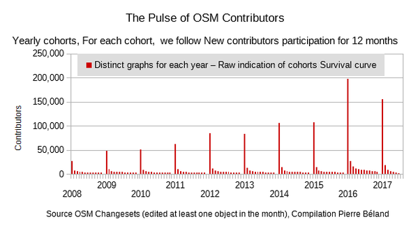
| Updated contributor stats - the end of maps.me |
In my Pulse of OSM Contributors diary, I did follow each year cohorts of new contributors. As we see on the graph below, year after year, the great majority dont come back a second month.
Statistics about proportion of contributors by days of contribution also show a large percentage with 2 days or less. It would be interesting to see if contributors starting with mobile tools or via remote mapping in mapathons have a different Survival curve. Looking at trends globally does not reflect the reality in various countries. I agree that POI contribution by phones or other mobile tools are valuable. This I suspect is the main contribution of local mappers in Africa. How can we help them to build a good map from there plus take account of massive remote contributions from remote mappers plus quality problems ? |
|||||||||||||||||||||||||||||
| OpenStreetMap Imagery sources by Continent / Sub-Continent, 2022 | I did attribute a Changeset to a Continent / Sub-Continent if at least 70% of the Bbox is inside a particular region, otherwise classified as Nd. |
|||||||||||||||||||||||||||||
| Maxar usage over the last year | @pnorman revision to find ‘%maxar%’ in either the source or imagery_used : ((tags->’source’ ILIKE ‘%maxar%’) OR (tags->’imagery_used’ ILIKE ‘%maxar%’)) |
|||||||||||||||||||||||||||||
| OpenStreetMap is in trouble | The Planet OSM Changeset metadata file let’s measure these contribution from the Map builder editor. Below Changeset statistics show a minor impact so far. In 2021, 3,768 objects were edited over 40 days with the unique account “Map builder user”. In 2022, there were 1,506 contributors with the random usernamesstrings, In total, they participated 1,700 days and edited less then 70,000 objects (ie. nodes, ways, relations).
|
|||||||||||||||||||||||||||||
| Mapping farmers markets in leaflet | Thanks Hans, Is this R language that is used to interpret this source ? |
|||||||||||||||||||||||||||||
| OpenStreetMap Carto release v5.7.0 | In this case, the ice_road=yes is tagged on the relation for this route https://www.openstreetmap.org/relation/9068170 |
|||||||||||||||||||||||||||||
| OpenStreetMap Carto release v5.7.0 | Thanks for paved / unpaved. Will there be rendering for Ice roads like https://www.openstreetmap.org/way/651548293#map=16/51.4979/-57.4899 ? |
|||||||||||||||||||||||||||||
| The 20% drop in new contributors (preliminary analysis) | Revisiting Heigit stats, I realise that MissingMaps do not include all tasking manager sessions. We have a different perspective selecting All projects with an increase in 2021-2022 over 2020. Analysis of CSV files should show profile by organisations using the tasking manager. |
|||||||||||||||||||||||||||||
| The 20% drop in new contributors (preliminary analysis) | thanks Simon and Norman for these insights. Heigit provides Tasking Manager Session statistics for missingmaps at https://humstats.heigit.org/statistics.html?org=missing_maps Statistic files can be downloaded and the graph titled Total Mapped Sessions by Usergroup presents a profile of Task manager sessions by user’s experience. Looking at this graph, we observe a drop of sessions from 2019. More contribution in 2021 is followed by a sharp drop in 2022. And this drop is not only from the less experienced. Session statistices is not the best indicator but confirms the drop of contribution in the last few years. It would be interesting to see such profile by No. of contributors and Objects edited. |
|||||||||||||||||||||||||||||
| Testing planet import | Hi mmd, for those that are not familiar with these programming tools, could you describe what type of import is done exactly with Planet-OSM - moving into Overpass db or anything else ? |
|||||||||||||||||||||||||||||
| Opening up HOT Governance (help wanted) | Hi Heather For people that are not familiar with the HOT organisation, could you clarify Who is the we that want to shift the governance model at HOT? - The membership - The Board - The Governance working group |
|||||||||||||||||||||||||||||
| Cleaning up large, untagged ways | @richlv to test if less careful changes to forests and other areas, a first step would be to search OSM history using overpass with the [date: YYYY-MM-DDT00:00:00Z’] parameter to assure the way was not previously a relation member. |
|||||||||||||||||||||||||||||
| Mapping leads to the end of winter | Upper north on the Richelieu river near Montréal, the canadian and white geese should halt in march-april coming from areas like Chesapeake Bay and similar areas south of USA. In october-november they halt again coming from up north. They also make these nice V-shaped formation! Bonne cartographie. |
|||||||||||||||||||||||||||||
| Lot of frustration due to bad H.O.T. tasks | Hi @pedrito1414, What we should try to do is find ways to better document the process and provide infos for better monitoring. The OSM Togo contributor changesets history around 4 years ago shows that he used the same changeset in various countries including South Africa https://www.openstreetmap.org/changeset/56700180 , USA https://www.openstreetmap.org/changeset/56701932 To better document, I think that it is better to add other tags to the changeset, letting the contributor describes is contribution in the changeset command. The call to osm editors from the Tasking manager and similar projects should simply add distinct tags to better reference the process. Adding host=url link Project + tags for task and action (mapping or validation) would facilitate monitoring projects from the Changesets metadata. |
|||||||||||||||||||||||||||||
| Lot of frustration due to bad H.O.T. tasks | @G1asshouse, these hashtags are inexact since they refer to a Togo project. A contributor might have move from one TM project to the other and forgot to change his Changeset comments. We also need to assure a better identification of Coordinated projects. It seems that iD now adds systematically in the changeset metadata the tag host with the url link to the project. This should be more systematic and also appear from edits in JOSM and other editors accessed from the Tasking manager. See https://www.openstreetmap.org/changeset/115157629 that contains
In case of TM projects, we can interrogate the API to validate if changesets metadata will refer to the exact TM project. This is not the case actually since the Project creator manually insert the TM project id in the Comments. I spotted mentions with no TM id or wrong id. See recent examples in the list below. TM projects with inexact Project reference
|
|||||||||||||||||||||||||||||
| Lot of frustration due to bad H.O.T. tasks | @pedrito1414 The changeset related to way 1013314708 mentionned at the beginning of this diary. refers to TM-11385 that completed in the last few days. Highway https://www.openstreetmap.org/way/124549760 deserves a mention since we see 10 highways reported as underground. This highway did already exist in the database before this project. A contributor traced buildings over it, then revised the highway tags, adding layer=-2. See this Overpass query that loads both the highway and the overlapped buildings. |
|||||||||||||||||||||||||||||
| Lot of frustration due to bad H.O.T. tasks | I should add about monitoring with Osmose, that there is delay reporting from Osmose. As we can see on the Age column of the summary report, items reported are from an observation 2 days ago. If a contributor corrected the problem since then and we try to edit, we will see that the problem is already fixed. |