Bin grad einen Teil des Weserradwegs langgefahren (geiles Wetter für so eine Tour!) und wunder mich jetzt. wo die Route eigentlich “offiziell” verläuft. Zwischen den Daten in OSM (für die Tour D-9), der Route beim ADFC und der tatsächlichen Ausschilderung gibt es etliche Unterschiede. Wonach sollten sich die OSM-Daten nun richten? Gibt es eine Karte mit der tatsächlichen Route?
OliverG's Diary
Recent diary entries
Near the airport of Bremen there is a historic memorial site for the italian olympic swimming team which died in an airplane crash in 1966.
Some time ago I photographed the text of that monument to enter it in OSM (as “inscription=” text). However half of the text is in italian, and I don’t understand it well enough to make a faithful transcription. Maybe somebody who reads this would like to post a transcription in the comments below?
Also, the inscription is in all upper-case letters, and uses line breaks for dividing the text. Should the inscription= value in OSM use the original upper-case letters, or correct upper/lower case text? And should the line breaks be replicated faithfully, or should this be one text without line breaks?
The text was photographed in six images; three for the german-language side and three for the italian-language side.
German inscription:
- http://wiki.openstreetmap.org/wiki/File:Monument_airplane_crash_bremen_1966_1.jpg
- http://wiki.openstreetmap.org/wiki/File:Monument_airplane_crash_bremen_1966_2.jpg
- http://wiki.openstreetmap.org/wiki/File:Monument_airplane_crash_bremen_1966_3.jpg
“Dieser Gedenkstein wurde vom italienischen olympischen Komitee und italienischen Schwimmverband zur Erinnerung an sieben italienische Schwimmer ihren Trainer und einen Reporter deren junges Leben am 28.1.1966 bei einem Flugzeugabsturz über Bremen zerbrach, errichtet”
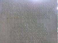
Italian inscription (as far as I understand it):
- http://wiki.openstreetmap.org/wiki/File:Monument_airplane_crash_bremen_1966_4.jpg
- http://wiki.openstreetmap.org/wiki/File:Monument_airplane_crash_bremen_1966_5.jpg
- http://wiki.openstreetmap.org/wiki/File:Monument_airplane_crash_bremen_1966_6.jpg
“Il 28. gennaio 1966 nel cielo di brema si infrangevano per crudele destino le vite dei giovani nuotatori italiani Bruno Bianchi Amedeo Chimisso Sergio De Gregorio Carmen Longo Luciana Massenzi Chiaffredo Rora Daniela Samuele Allenatore Paolo Costoli Telecronista Nico Sapio Mentre Erano Avviatiad una gioiosa competizione di sport il comitato olimpico nazionale italiano e la federazione italiana nuoto posero questa stele sul luogo del sacrificio per affidare il ricordo degli scomparsi alla fedele e fraterna amicizia degli sportivi di germania”
Bike tour from Bremen to Oldenburg, along the river Hunte
Posted by OliverG on 31 May 2008 in English.So after having done that bike trip twice before without any mapping gear, I took a GPS receiver and my eeePC with me this time! The data includes some bike ways that have not been mapped before (opposite from Bremen steel factory; and from Huntebrück to Oldenburg). It also contains the main street of Lemwerder - that small city seems to have absolutely no mapping data so far. Hope to turn the traces into maps tomorrow.
Btw. though the eeepc caused some hassle at first (I didn't dare to fully close the lid, as the heat from the CPU might damage the display; so there was some blocker needed to keep the lid open a bit), it went quite well in the end. Data logging was fine with gpxlogger, at least after I noticed that its default interval of five seconds might be too coarse, and set the interval to one second; and by turning off Wifi and screen the eee managed to stay alive for four hours on battery.