
Holborn pub meet-up. Spitalfields TONIGHT
Posted by Harry Wood on 7 November 2013 in English. Last updated on 20 December 2013.It’s winter time in London. Time for the OpenStreetMap winter pub meet-ups. Kicking off TONIGHT!
Our last “summer” meet-up was “just a pub” anyway, so this is a smooth transition. Last time we were in the Penderel’s Oak in Holborn on a Tuesday. I’ve been avoiding Tuesdays because I have Portuguese class, but thought I would try to cater to the important subset of our community… “those who like Tuesdays”… while cunningly picking a pub near my Portuguese language school.
Incidentally my language school is this “EC” building (though the school is called “citylit”). In the reception area there used to be a canvas wall-mounted arty picture, about 3 foot wide, and it was OpenStreetMap! Fairly standard rendering except the colours were changed around to be very dark purpley/blue, perhaps done with CloudMade style editor or something. Quite pretty. Sadly it’s been taken down now. I thought I had a photo of it… [UPDATE: I’ve found the photo of it!]
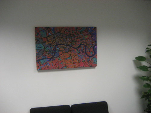
I’ve no idea how this came to be produced. It’s the kind of canvas picture you might buy in IKEA (the biggest retailer of art apparently). The other interesting thing about the EC building is that there’s a cheap cheerful spacious cafe hidden at the top of the stairs. I keep thinking it could be a good venue for a laptop oriented meet-up (armchair mapping, or hacking, or a something). I think technically the cafe is only for registered students, but there’s nothing to stop other people walking in. It’s just very well hidden. I’ll add it as a vague possibility for a London event venue.
Speaking of London events, before I go on, let me mention the London Hack Weekend. Matt has organised this to be hosted at the MapQuest London offices on 30th Nov/1st Dec. There will be some food… if you sign up! These are great fun events, no matter how techy you are, so quite sad to be missing it myself. But you should get yourself added to the list. Thanks to MapQuest again for their generous support.
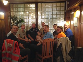
Anyway… so last time… after learning portuguese, I headed to the Penderel’s Oak a bit late, and sure enough a good OpenStreetMap gathering was in full swing.
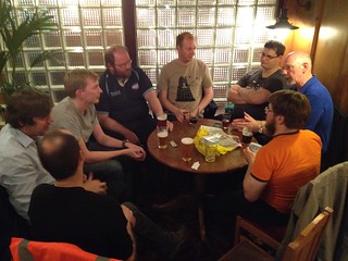
…and so I purchased a cheap weatherspoons ale, pulled up a seat, and joined them. …and this made me smile:
Andy brought a pile of new leaflets. They’re a similar design to the previous ones, but Andy’s reworked the map examples, and the explanations a bit. The previous leaflets had illustrations showing mapping a street network from a blank slate, by recording GPS tracks to get the positions of roads. This is not something most new mappers will experience these days (unless they’re in a lesser mapped part of the world). So if you look at the design of the new leaflets you’ll see a more general “how does OpenStreetMap work” overview, and there’s an appearance of the wonderful Mr Globe! Hurray!
On the topic of new user’s experience, and not getting to fill in blank spots, Dan Stowell had an interesting way of putting it: “You can help do the weeding but you can’t design the garden”.
We had quite an extensive discussion about engaging new mappers.
Perhaps we’re not doing so well these days at noticing and celebrating eachother’s mapping work. Again this is to do with the lack of blank slate mapping work remaining. We used to delight in seeing somebody new coming along a blatting in a whole town, nowadays there’s less of this kind of progress to celebrate, but even so, is there a way we can do better a noticing and bigging up the mapping progress that people are achieving.
Another thread of discussion was around selling people on the idea of OpenStreetMap. There’s quite a mental leap for people to understand geodata, versus just the visual map, both in terms of understanding the mapping process (raw data input results in the visual map), and in understanding that geodata can be so much more than just one visual map. In general having demonstrable applications of OpenStreetMap is interesting for new users, but particularly if you can start the conversation by listening to what interests them.
We talked about OpenStreetBugs, and are people seeing them and solving them enough to get the cycle working well? Are we tending towards the MapDust problem of too many low quality bug reports?
User:Tallguy was telling us he’s worked a lot on bus routes data, but found people have damaged or deleted his route relations over time. Reverting such damage is harder than just re-inputting. Change tracking and reversion tools for relations are a bit difficult. Derick’s looked at making bus route relations mapping video, but it involves a lot of processing. Also on the topic of buses, firefishy figured out how to receive live bus movements data for a region in South Africa, by tapping into a feed designed for an android app. He’s puzzling through the challenges of showing moving markers on a map, or figuring how to show time estimates for buses approaching a stop. Quite similar to some challenges I’ve tackled for transportapi.com, although TfL gives the data the other way round so this kind of display (buses going past that pub) is fairly easy.
On the topic of Android we discussed an interesting article which enumerates the various ways in which google exercises quite an evil level of lock-in over the android platform. A platform which people tend to think of as “open”. Sounds familiar? People tend to think of google maps as “open” too of course (Yes they really do. Talk to tech people outside of OpenStreetMap circles. Plenty of smart developers will say “but isn’t google maps open?”) But anyway looking at the different dimensions of google lock-in for the android platform, on page 4 there’s a mention of maps (specifically maps APIs for mobile apps). Obviously OpenStreetMap has a role to play offering app developers, and developers of alternate android platforms, with a choice. Also on that page it’s interesting to read about how “Android’s top-tier location services are now closed source”. Of course all of this evilness pales into insignificance compared to Apple’s iOS kingdom of evil, but it does make me think, maybe we should really be supporting a more pure form of openness. — Snap back to reality — “Ooh there’s my iPhone. Shiny.”
We also talked about some xkcd comics, and then observed a kind of “xkcd chinese whispers” effect, when someone tries to relay a half-remembered originally hilarious xkcd comic to the group by describing it verbally.
If you’d like to play this game …or even chat about OpenStreetMap …why not come along to the pub TONIGHT! We had a geomob last week, and someone was recommending The Gun pub in Spitalfields, so I decided we should give it a try. We need a bit of variety. It is rather easterly, but easy to get there on the central line. No excuses now. Sign up on lanyrd (It was looking a bit quiet on there this morning, but I’m pleased to see there’s more than two of us going!) More details on the new winter events wiki page. We should probably have gone to this pub as a mapping location. Maybe I’ll do a cheeky bit of mapping on the way there. Mapping is allowed.
Discussion