
UCL masters student mapping party
Posted by Harry Wood on 13 October 2010 in English. Last updated on 24 October 2010.The UCL masters student mapping party took place a couple of weeks ago (another thing from my blog backlog) We showed a class full of students how to do mapping. These were masters students just starting on a new geomatics course. The idea was put forward by Muki Hacklay and organised by Thomas Koukoletsos in consultation with a few OSMers: myself, Dan Karran, and Sam Larsen.
We started with a little "lecture" about OpenStreetMap. Reminiscent of my student days, I got there a bit late, and planned to go sit at the back, but as it turned out Thomas quickly handed over to me to explain OpenStreetMap. My unprepared explanation followed the lines of various talks I've been giving, at least at the start, but for the rest of the day I remembered other things I should've said.
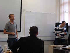
The plan was to go map some details in Camden, particularly missing shop POIs. Thomas handed out some walking papers printouts he'd prepared earlier, and also cake diagrams, but it was left as a class exercise to figure out how to sub-divide the cake slices into smaller areas so that everyone could work in pairs. A bit chaotic, but it forced everyone to get to know each-other. Ant and Deb from Mapquest were sneakily hiding in the audience pretending to be students.
Then we headed out mapping! For some students this was a first exploration of London, having arrived from foreign countries. We spent a while sorting out oyster cards for some of them (and then for me when I realised mine had run out too!) and then tubed it up to Camden. This is one of my favourite areas of London, but it's also a bit skanky and crime-ridden (does that say something about me?) Certainly Camden isn't at its best on a rainy Wednesday afternoon.
Since this was supposed to be a learning exercise there was a certain amount of letting them "make their own mistakes", but it is a problem with the OpenStreetMap mapping process, that a beginner doesn't really know what kind of data to gather until they have a feel for map editing, and they have no map editing to do, until they gather some data. So with the pair that I was with, I did tell them exactly what to note down as we started walking around. They seemed to get the hang of it, and started to get the idea too, that you have to develop ways of gathering data rapidly, shorthand note styles etc, to speed up the process and keep moving.
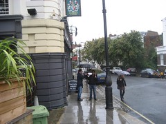
Rain was a bit of downer, so we headed to the pub a early. Most of the students made there way there, even though this wasn't a compulsory part of the exercise! and we were gradually joined by more and more of the normal OpenStreetMap crowd. We chatted with the mapquest folk, and then a bunch of cloudmade folk turned up too! Quite a gathering. Pleasantly surprised by the The Worlds End pub. It can be very noisy in there, but it worked OK.


The next day we showed the students how to input their data using Potlatch. Too often I've had chance to show new people how to gather data, but then had to leave them to figure out how input it. This of course is the technical part of the process, so it was really good to be able to guide them through the whole process. It will have left them with a fuller understanding of how to contribute. It was also surprisingly valuable for us in terms of understanding where newbies get stuck. I thought we had a good idea about some of these sticking points, but when you see a room full of 20-odd people grappling with the website from the initial sign-up stage. Well Andy started writing some notes, which turned into an awesome blog post, leading to an even more awesome bit of rapid issue fixing by Tom Hughes!
Once people got into their stride with Potlatch editing, it was all good fun. Later on we saw some of them editing their home towns. That's it! They've got the OpenStreetMap bug!


From an educational point of view, I believe the two days were a great success. In a short time (one afternoon, one morning) students learned a new skill. A simple way to create, or at least help to create, a digital map. This includes basic principles and practical experience of on-the-ground orientation for surveying. Surely an important foundation skill. One might well struggle to describe OpenStreetMap editors as "Professional GIS software", but learning to edit in Potlatch is also sensible as a foundation skill for the beginning of a GIS course. What other vector map editing environment will let you quickly learn how to see and manipulate map vectors one moment, and publish changes to a worldwide raster map the next (not to mention collaboratively sharing your changes within a open licensed geo database) ?
No doubt the students will be learning more complicated aspects of GIS and geoinformatics throughout the term. I hope they'll think back to OpenStreetMap when it comes to looking for interesting geodata sets to work with on their course.
I want to thank the Muki Hacklay and Thomas Koukoletsos, for having the idea and organising this event. I hope they also found it to be successful, and that we can look at repeating the experience. And I hope other universities might consider a similar OpenStreetMap exercise. I think we can use this as one of the case studies on our 'Education' page.
Discussion