
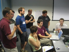
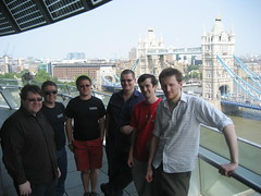
We've just had our OpenStreetMap Government Technical Workshop and hack weekend. We had Gareth Baker and Sandy Pacek from the Greater London Authority, Scott Day from London Borough of Southwark, and Alisdair Maclean from London Borough of Brent, all gathered in the spectacular London City Hall building along with a whole bunch of OpenStreetMap hackers.
This was a really interesting meeting of minds. The kind of rapid agile open source development carried out by OpenStreetMap hackers is worlds away from government-style heavyweight GIS. We know that OpenStreetMap has data and software which can solve their problems, and discussion on Saturday reinforced that for me. But I also have an impression that they are unlikely to attempt to solve the problems for themselves by delving into our our chaotic SVN repos, wikis and development community. There's a gulf there. If we can find ways of taking the solutions to them, we can start to bridge this gulf.
More on Tom Chance's blog post 'Map geeks in the bowels of City Hall'
A few specific discussion points and ideas which I'd noted down:
Internal users of GIS data within local councils would likely be able and willing to contribute to OpenStreetMap provided we can clearly show them how the data will help them and their work.
Alisdair Maclean was very positive about supplying data to OpenStreetMap from London Borough of Brent. He handed over a dataset for streets, which they had commissioned to be surveyed free of Ordnance Survey copyrights. Useful for comparison with our surveyed data. Alistair also mentioned a number of datasets such as Controlled Parking Zones which he would love to open up, but there are OS derived data issues.
We heard about some other councils, for example Redbridge council are super keen on opening up all their data. Hackney are going crazy for google maps.
The GLA IT people have done some large geo-data related projects last year, but at the moment the focus is on open data in general for the london datastore. We heard about the difficulty of bringing together datasets from many local councils. For example, they did a project which needed data on allotments. They had to request this data from every council separately, wait for a reponse from each of them, and then reconcile a variety of formats they got back. They received things like CSV files, in some cases just printouts. Mostly nothing as advanced as a GIS data file.
The GLA don't have "spare" servers as such, because it's all virtualised, but we could potentially host something up there anyway. The way to make that happen would be to supply a written proposal describing the services we would run.
WMS server & tiles servers providing OSM renderings in OSGB projection would be very useful to many desktop GIS software users. XAPI style POI exports in simple CSV formats might be useful.
Scott Day described some MapInfo features and file formats. He also mentioned that MapInfo have released a new version which includes a built-in tileserver.
Some practical work
Practical work a.k.a "hacking". We got a few things done in amongst discussions and balcony viewings on the Saturday, and the world cup match on the Sunday (less said about that the better)

I worked on a hack related to MapInfo. Something Scott Day will hopefully find useful. A little java program called TileTabber which creates MapInfo TAB files placed alongside downloaded tile images. These TAB files contain the coordinates of the corners of each image.
Tom Chance experimented with vectorisation of buildings from Ordnance Survey StreetView. See that link for a description of the long chain of conversion steps through various tools. The initial vectorisation (into SVG) was carried out using a tool called potrace.
Andy Allan (Mr OpenCycleMap) has been handed a dataset of ~2000 bike shops, which we can use in OpenStreetMap. Locations are only approximate (postcode centrepoints) so the data can't be imported directly. Instead he & Shaun hacked together a wee rails app to present the data and get people to manually check if it corresponds to data we already have, or a shop=bicycle node needs adding. This isn't available to play with just yet.
Robert Scott has been working on OSL Musical chairs a tool for finding discrepancies between OSM and the OS Locator data set (Ordnance Survey open data) Originally outputting CSV, he recently added a map display. ITO world did a similar OSL comparison as background tiles, but OSL Musical chairs has different text comparison logic. During the hack weekend Robert made some improvements and looked at bringing in alternative data sources e.g comparing the Brent data with OSM. Plus he worked with Tom on the vectorisation stuff.
Steve Chiltern came along on Sunday. I asked him to take a look at the Mapnik view of Girona and try to make some stylesheet tweaks to improve matters after the Girona Imports. Mostly not a good idea to fix renderings to cope with imports, but we looked for some reasonable improvements.
Gregory has been wokring on an app recording the usage levels of cycle racks at different times of day. This is to develop a linked dataset (Not the kind of data to go in OSM)
Grant and TomH did their sys admining thing. They needed to figure out some new hardware to place an order for, and a plan for deploying it. Grant also had a play with the data for London Borough of Brent, loading it into JOSM as a GPS layer to allow comparison.
A wide variety of hacking. Not all government related, but as described above, there's plenty of government ideas left to work on still.
We'll aim to hold another general hack weekend, perhaps in August. I certainly hope we'll be able to bring together government people again some time too. In the meantime we have a number of events coming up, the next one being TODAY! A summer evening mapping session in Belsize Park. Join us!
Discussion
Comment from mikelmaron on 30 June 2010 at 01:43
Good work, love the outreach
Comment from Tom Chance on 30 June 2010 at 06:50
I think you're spot on about the need for outreach, Harry. Let's see how things go with those pioneers we know about in UK local gov, and think about a larger weekday event later in the year / early next year to draw in potential early adopters with some nice Brent/Southwark/Surrey/GLA case studies.
p.s. my surname is Chance not Acrewoods ;-)
Comment from Harry Wood on 30 June 2010 at 08:57
Oopse. Fixed. That's funny because I kept reminding myself "his surname is Acrewoods not Chance", but no! also was forgetting to link to your blog post