OpenStreetMap

Guttorm Flatabø's Diary

Recent diary entries

First impressions of Holux M-1200E

Posted by Guttorm Flatabø on 27 December 2012 in English. Last updated on 28 February 2013.

I recently bought an Holux M-1200E GPS data logger from Dealextreme. It seems to be the most affordable decent quality data logger out there with a MTK MT3329 chipset. For 50.99 USD I was supposed to pay customs in Norway, but since Dealextreme sends it as regular mail it slipped through that, and ended up really affordable.

I was a little reluctant buying it since I’ve struggled with the Holux M-241 before, however, first impressions are good. Using the MTKBabel perl program it is easy to extract data and manipulate settings, including adding HDOP, and setting point frequency both per meter and seconds (and speed if you want). I recommend going straight for MTKBabel and not struggle with gpsbabel.

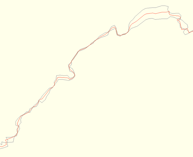
Accuracy is good (3-6 m in general), and fix really quite fast. I’ve had no problem connecting it over bluetooth to my Cyanogenmod 7.2 phone, but the two devices seem to have to be quite close to maintain a connection.

I’ve used it for 2-3 hours at a time, so I still don’t know how long it can last. Have a look at the wiki entry I made for how to extract data with MTKBabel.

Android phones with external GPS

Posted by Guttorm Flatabø on 13 August 2012 in English. Last updated on 24 August 2012.

There have been some discussions on the Humanitarian OpenStreetMap Team mailing list about using smaprtphones for tracing/tracking.

I have long been tracing with my phones, first with Symbian, tried iPhone and iPad, and now primarily with Android based phones. The best apps for tracing for OSM are available for Android solely (GPS Logger, Vespucci, OSMTracker for Android).

Unfortunately I have been unable to find a single details source which can say something about the quality of the GPS in smartphones, but have relied on experience, and from experience I can say:

  1. Smartphones are usually pretty accurate, but quality varies greatly and they will often get in trouble in steep and narrow valleys and the like.

  2. You should not trust the accuracy indicator. I have walked for up to two minutes with my phone claiming 4 meters accuracy, while the real accuracy was getting closer and closer to 500 meters. It looked like it used some predictive algorithm to fill in when it had signals but no fix with the satellites. Also, apps (such as GPS Status) will round down the accuracy and not up, so 3,99 m becomes 3.

  3. System bugs can give consistent skewing of position, so keep your system up to date.

  4. Don’t use any other source than GPS, they will not be reliable, nor helpful.

  5. Phones will claim to have higher accuracy than possible considering current tech. My Samsung Galaxy Tab would for example claim 1 meter, which is better than any of the chipsets listed on the OSM wiki.

  6. Using a high quality external bluetooth GPS with your phone will improve accuracy, reliability of accuracy and perhaps battery time.

Using external bluetooth GPS with Android smartphone

With standard Android you can use the Bluetooth GPS app to connect your external GPS to your phone. But if have the very excellent Cyanogenmod distribution 7 or newer on your phone you can simply pair the phone and the gps and select it as source in your GPS settings.

This has worked like a charm for me with a Holux M-241, though the reach wasn’t very long, and the battery time for the Holux sucks.

Please feel free to transfer some of this to the wiki.

GPS Logger for Android has recently been upgraded and now has three features very fitting for OSM trace logging:

  • Easy access annotation button (now working)
  • HDOP logging (accuracy)
  • Auto send to OpenStreetMap

It is also still free software, and uses OAuth to authenticate with OSM. I log 1 point per second and every 4 meters (which is usually the best accuracy I can get anyway) which makes for fine traces.

Waymarked Trails now in 7 more languages, and more to come

Posted by Guttorm Flatabø on 3 May 2012 in English. Last updated on 10 May 2012.

While hiking relations are being related (almost) all over the world, Waymarked Trails is adapting by partnering with Translatewiki to translate the user interface.

You can now translate Waymarked Trails like many others have, resulting in 7 new languages even before being officially added to Translatewiki.

Languages that have been started but have yet to complete include Russian, Portuguese, Hungarian and Japanese. Other interesting contenders include Zazaki, Interlingua, Luxembourgish and Telugu.

If you know of Waymarked Trails that are mapped, but have yet to be included in Waymarked Trails you can have them included by making relations according to the specifications in the wiki (see also the help pages).

Happy internationalized mapping!

Cite on the OpenstreetMap wiki

Posted by Guttorm Flatabø on 16 October 2011 in English. Last updated on 18 October 2011.

I wanted to cite a page on the Openstreetmap wiki, and looked for "Cite" in the toolbox, but it looks like the Cite plugin isn't installed.

Where can I ask for it to be installed?

As OSM data is being used more and more there will be a need for citing the features pages especially, and the Cite plugin hadles it very well, and integrates with the Zotero citation software.

Update: The Cite plugin is installed, but the "Cite this page" feature that is available from the Toolbox menu on Wikipedia articles is not available on the OpenStreetMap wiki.

After some research it looks like the SpecialCite.php extension is needed in addition.

Average tracks: drawing a "line of best fit" automatically

Posted by Guttorm Flatabø on 26 September 2011 in English. Last updated on 13 October 2011.

Do you have many not so accurate tracks from the same hike, drive or route lying around? Would you like to take advantage of all that data and merge them into a “line of best fit” / average track?

Try the average tracks script.

The accuracy of the points in a single GPS trace may be out by several meters. This depends on lots of factors such as the positions of the satellites when the trace was taken, tree cover, proximity to nearby buildings, position of the GPS unit relative to the center of the road etc. If many traces are taken for the same road, then the effect of errors in any one trace will have a much smaller impact on the average position of these traces. (from "Good practice" on the OpenStreetMap wiki).

Made by Michiel Faber, and given a home and documentation by Guttorm Flatabø, this is a first step, using R. With increased use and contributors we could soon have something more functional. The script comes with no warranty, use at your own risk, and please report bugs, improvements etc. on github, or directly to Michiel or Guttorm (using OSM messaging).

The work on this was done in connection with the Northern Periphery Program project Tourist Guide for the Northern Periphery.

Location: Hangsete, Sogndal, Vestland, Norway

MapSpot claims they wanted to make an open map for Georgia, and now they've gotten their database into Google Map Maker. Their map seems to be inferior to OSM, it also looks like they might have used OSM (at least they've used Wlaking papers), so what is it?

Why haven't they just contributed to OSM, or have they?

http://omc.ge/en/projects/mapspot
http://mapspot.ge/

After three years I finally start using my account!

Hopefully I'll be contributing roads and hiking trails in the Sognefjord area.

However my first attempt has been to upload a track of a kayaking expedition. It isn't really that usable for making maps, so more there for experimenting.

Is there some way for me to have my track as a layer on top of a more complete map?