Greeting awesome OSM,
Note #1558 mentioned that border of Egypt-Sudan was too winding/wobbly..I’ve checked it and he seems right refereeing to Official UN Africa map and Egypt govern provided map the border should be a straight line…here is the note: ((please pay attention that I’m not talking about Halaib/Shalatin problem here I’m talking about the line of the border itself should be straight not that wobbling)). http://www.openstreetmap.org/note/1558
and here is the UN Africa Cartographic Africa Map: https://www.un.org/Depts/Cartographic/map/profile/africa.pdf
Egyptian State Information service official Egypt map: http://www.sis.gov.eg/newVR/map.pdf ref. http://www.sis.gov.eg/En/Templates/Articles/tmpArticles.aspx?CatID=20
more on Egyptian Ministry of Communication and IT map http://www.mcit.gov.eg/images/maps/Intl_Boundaries_map1.jpg http://www.mcit.gov.eg/images/maps/Governorates_map3.jpg reference: http://www.mcit.gov.eg/Egypt_Maps
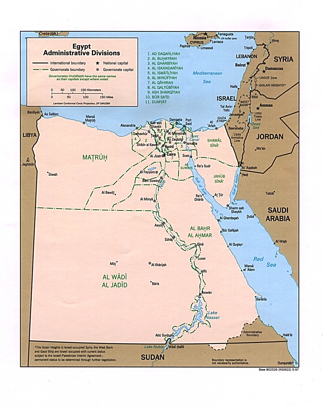
U.S. Central Intelligence Agency reference Map https://www.lib.utexas.edu/maps/africa/egypt_admn97.jpg university of Texas Library reference: https://www.lib.utexas.edu/maps/egypt.html
Finally to summarize…The border line should be just above 22°N latitude as shown here clearly: http://www.mapsofworld.com/egypt/
The idea is that I can’t edit the map as ID editor doesn’t help too much in very long lines,I’m asking help for JOSM experts to edit the border and match it with 22°N latitude and clear that border wobbling.
thanks in advance..
Discussion
Comment from dcp on 6 January 2014 at 06:57
This border was last edited by RedFox (Language French).
http://www.openstreetmap.org/user/RedFox on the 27.Dec.2013.
It was initially entered by Schäuble Michele
http://www.openstreetmap.org/user/Sch%C3%A4uble%20Michele on the 28.Jan.2008
It would be advisable to contact them first.
If you have no success I’ll do it.
Comment from RedFox on 6 January 2014 at 10:42
Hi.
I’m not the one who have edited this segment of boundary. I’ve just added and removed some keys.
I’ve found strange the delimitation, but I have not taken the time to find some documentation about it to correct the way.
Librement,
Comment from رامز on 6 January 2014 at 18:53
thanks @dcp I’ve contacted @Schäuble Michele and hope he will respond soon.. and it’s great to see @RedFox has joined our discussion, I hope I’ve provided enough documentation to you sir to fix the border line or at least learn me how :D
Comment from Ohr on 6 January 2014 at 19:56
I just compared the current data with an updated version from the US Department of State. There are also other differences. So I would even suggest to replace the existing data from the CIA World Database with the more accurate ones from LSIB.
Comment from Schäuble Michele on 6 January 2014 at 22:01
I did the original import nearly 6 years ago. The data is based on the CIA World Database and the import was documented on the following wiki pages:
Since the “wobbling” effect is also visible on other borders and is caused by the inaccuracy of the data, I don’t think it makes sense to manually fix the borders. There is much better data available now which should be considered to be imported instead.
Comment from رامز on 7 January 2014 at 00:48
thanks @Schäuble Michele for fast reply I’ve checked the WIKI page and surfed around with CIA WDB II, WIKIMEDIA geographical data sources and found that data is fairly old 1980! also the source doesn’t guarantee accuracy, So I’ve analyzed USA-Canada straight border line there was no wobbling at all also another African Mali-Algeria line and found the same issue so I guess it’s common in other countries “a lot in Afica I guess” so You’re right manual fixing of such great data would be a real pain but it’s good now that the key is importing data to OSM format, The idea is how? “sorry I’m a kind of newbie in that :)” Can you help me in importing such data or I’ve to contact OSM formally explaining the problem and asking for updating their country boundary database? as country boundaries is kind of critical data or what?
thanks in advance…
Comment from z-dude on 7 January 2014 at 03:48
The US Canada border loosely defined as ‘49th parallel’ is actually hundreds of segments defined by precisely measured monuments. See the http://internationalboundarycommission.org/
49th parallel segment http://internationalboundarycommission.org/coordinates/M49thp.txt
Comment from رامز on 7 January 2014 at 05:28
@alexz thanks for the info, but Egypt-Sudan line is exactly above the 22°N latitude so I think it’s a good reference mark while correcting the line!
Comment from dcp on 7 January 2014 at 06:42
@ رامز Can I assume that Schäuble Michele will take over this task. He seems to have more knowledge than I do.
Comment from Ohr on 7 January 2014 at 10:28
Some time ago I already updated some other borders with that from LSIB. From that I already have converted border data available for all of Africa. So I am happy to update the Egypt-Sudan segment based of the data. The worst part in this is fixing the administrative relations..
Comment from رامز on 7 January 2014 at 16:29
Great News (^_^) so whether @Ohr “thanks so much” or @Schäuble Michele will fix it (sorry if being leech) but kindly can you teach us “How To?” or the main steps for importing LSIB data to OSM to be kind of reference in the future as I can’t find it in Help or WIKI section (Only a small description by @ian29) https://lists.openstreetmap.org/pipermail/imports/2012-September/001504.html
Comment from Ohr on 8 January 2014 at 20:13
Ok, I’ve just updated the border and at least in higher zoom levels it is already rendered.
Regarding the process this is a bit tricky, involves a number of tools and for this reason not easily described. Here a short outline: The original LSIB data is a shapefile. I loaded this into QGIS and split it into different segments, still shapefiles. These shapefiles are converted into the osm format using ogr2osm.
After this comes the part of manually importing the data: I start by downloading the current borders in the area including the relations using Overpass Turbo. The result is loaded into JOSM as well as the result of the conversion above. Then I go through the existing border, remove the segments from the relations, split the new border at the internal borders e.g. governorates, and add the new segments to the relations. After that the old border can be deleted. Finally I re-check all the relations to make sure they are fine. Once all is OK I upload the data using a special import account.
Comment from رامز on 9 January 2014 at 11:36
@Ohr I do appreciate your help…thanks so much. Greetings from Egypt.. Ramez
Comment from rknbg on 14 January 2014 at 21:46
Thanks folks, that worked.
May I offer http://www.openstreetmap.org/note/1485 for desert? :-)
Border between Egypt and Libya should also be a straight line (not wobbling) along 25 East meridian.
Greetings from Germany, rknbg
Comment from rknbg on 14 January 2014 at 22:10
Same with http://www.openstreetmap.org/note/101833
Border should be at right angle, straight lines (not wobbling) from N20°, E24° east along N20° parallel and south along E24°meridian.
Sorry for serving piecemeal informations.
Comment from رامز on 15 January 2014 at 15:35
I think you should contact @Ohr directly.
thanks @rknbg..